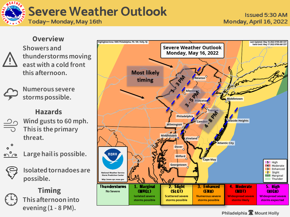
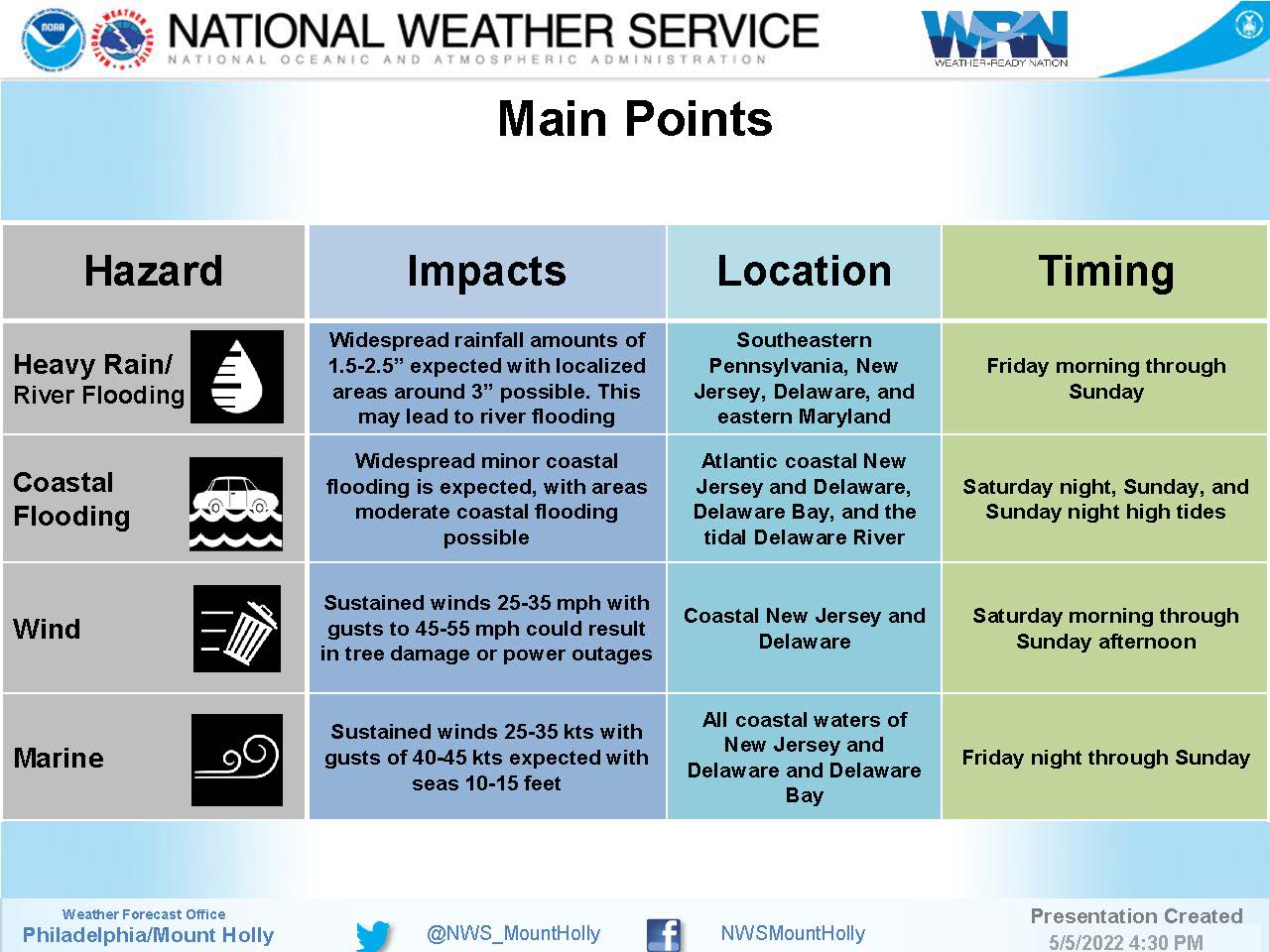
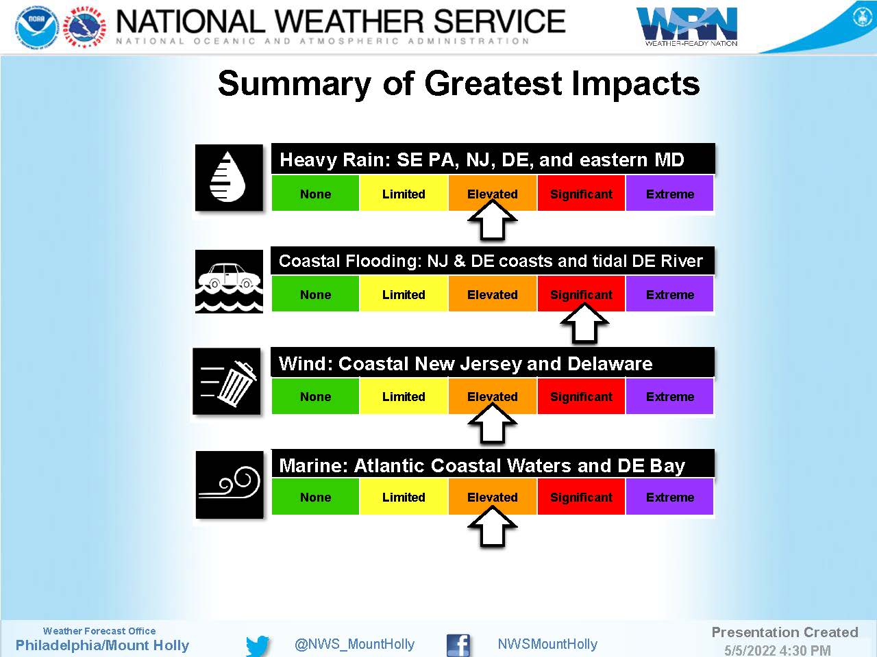
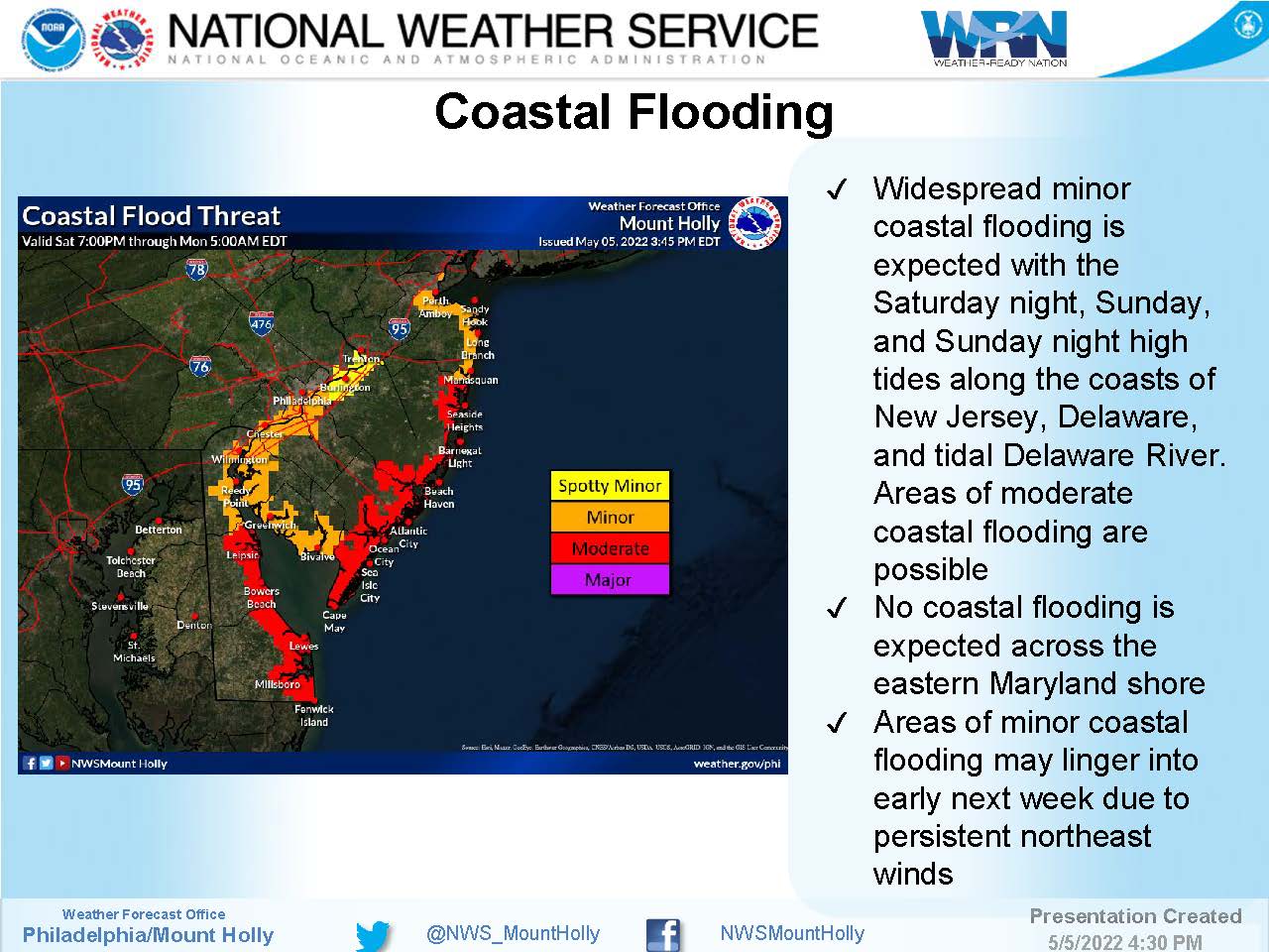
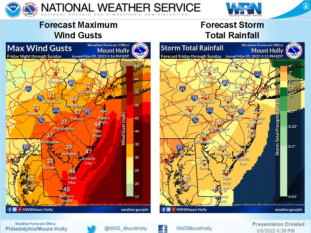
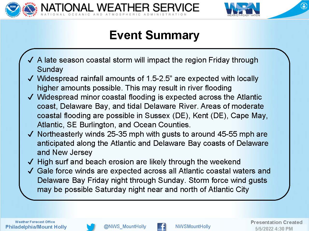
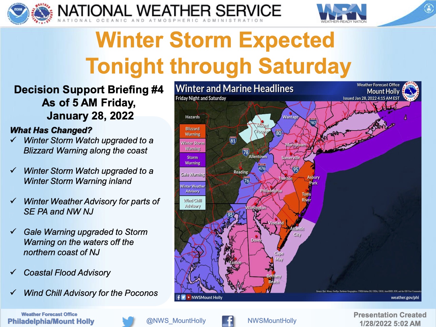
Wednesday, May 4th, 7:00am: Stone Harbor Boat Ramp Closure

The Stone Harbor boat ramp located on 81st Street will be closed today, May 4th, 2022 from 7:30am until 3:00pm for repairs. An alternate location to launch and retrieve your boats is located at 54th Street and Ocean Drive in Avalon.

Wednesday, May 4th, 7:00am: Stone Harbor Boat Ramp Closure2022-05-04T07:18:58-04:00

Monday, April 18th, 9:15am: Coastal Flood Warning for Stone Harbor; Strong Winds, Heavy Rain, Coastal Flooding

A COASTAL FLOOD WARNING WILL BE IN EFFECT FROM 7 PM THIS EVENING TO 3 AM EDT TUESDAY…

WHAT…One to two feet of inundation above ground level expected in low-lying areas near shorelines and tidal waterways.

WHERE…In New Jersey, Cape May and Atlantic Coastal Cape May. In Delaware, Kent, Inland Sussex and Delaware Beaches.

WHEN…From 7 PM this evening to 3 AM EDT Tuesday. High tide occurs at 10:41 PM

IMPACTS…At this level, widespread roadway flooding occurs in coastal and bayside communities and along inland tidal waterways. Many roads become impassable. Some damage to vulnerable structures may begin to occur.

PRECAUTIONARY/PREPAREDNESS ACTIONS… A Coastal Flood Warning means that moderate or major tidal flooding is occurring or imminent. Be prepared for rising water levels and take appropriate action to protect life and property. Follow the recommendations of local emergency management officials. Do not drive your vehicle through flood waters. The water may be deeper than you think it is. You will be putting yourself in danger and your vehicle may be damaged, leading to costly repairs. Visit the Advanced Hydrologic Prediction Service at water.weather.gov/ahps for additional water level and flood impact information for your local tide gauge.


Monday, April 18th, 9:15am: Coastal Flood Warning for Stone Harbor; Strong Winds, Heavy Rain, Coastal Flooding2022-04-18T09:16:40-04:00

Monday, April 4th, 9:19am: Stone Harbor Boat Ramp Closure

The Stone Harbor boat ramp located at the 80th Street Marina will be closed for repairs from Wednesday, April 3rd until Friday, April 15th. An alternate location to launch and retrieve your boats is located at 54th Street and Ocean Drive in Avalon.

Monday, April 4th, 9:19am: Stone Harbor Boat Ramp Closure2022-04-04T18:56:38-04:00

Friday, January 28th, 7:10am: Blizzard Warning for Stone Harbor; Strong Winds, Heavy Snow Expected

The National Weather Service has issued a Blizzard Warning for the southern New Jersey coastline.  The Warning is in effect from Friday, January 28th at 7pm until Saturday, January 29th, at 7pm.  Blizzard conditions are expected with wind gusts approaching 50mph and the potential for 8-15” of snowfall.  A Coastal Flood Advisory is in effect on Saturday from 3am until 9am; minor tidal flooding is expected.

Travel conditions will be difficult to impossible during this storm event.  Driving late Friday night through Saturday is not recommended.  Snow is expected to end at some point Saturday afternoon.

Contractors are required to secure their job sites before they stop work for the day on Friday.  Consider securing objects on your property that are prone to strong winds.  Beach erosion is likely during this storm event.  If you have any emergency, dial 911.  If you experience a power outage, please call Atlantic City Electric directly at 1-800-833-7476.

Friday, January 28th, 7:10am: Blizzard Warning for Stone Harbor; Strong Winds, Heavy Snow Expected2022-01-28T07:11:18-05:00

Thursday, January 27th, 5:16pm: Winter Storm Warning Issued, Heavy Snowfall Expected

The National Weather Service has issued a Winter Storm Warning for our region.  The Warning is in effect for Friday, January 28th, at 7pm until Saturday, January 29th, at 7pm.  The current forecast calls for total snow accumulation of nine to 15 inches, and wind gusts of up to 50mph.

Hazardous travel conditions are anticipated late Friday night through Saturday.

There is no significant tidal flooding associated with this storm event.  Exercise caution while driving and be aware that snow plows will likely be on our streets to clear snow as quickly and safely as possible.  If you have any emergency, dial 911.  Friday is the day to secure outdoor objects like trash cans and patio furniture that are subject to strong winds.

Here is the Winter Storm Warning issued by the National Weather Service:

Winter Storm Warning

URGENT – WINTER WEATHER MESSAGE

National Weather Service Mount Holly NJ

337 PM EST Thu Jan 27 2022

…WINTER STORM WARNING IN EFFECT FROM 7 PM FRIDAY TO 7 PM EST

SATURDAY…

* WHAT…Heavy snow expected. Total snow accumulations of 9 to 15

inches. Winds gusting as high as 50 mph.

* WHERE…Portions of central and southern New Jersey and

southern Delaware.

* WHEN…From 7 PM Friday to 7 PM EST Saturday.

* IMPACTS…Travel could be very difficult to impossible. Gusty

winds could bring down tree branches.


* ADDITIONAL DETAILS…Snow is expected to begin Friday evening in

Delmarva and southern New Jersey, spreading northward overnight

into Saturday morning. Snow may be heavy at times through mid

afternoon Saturday before diminishing Saturday evening. Strong

winds may generate blowing snow and very low visibilities at

times.

Thursday, January 27th, 5:16pm: Winter Storm Warning Issued, Heavy Snowfall Expected2022-01-27T17:17:30-05:00

Thursday, January 27, 7:07am: Winter Storm Watch Issued by National Weather Service

The National Weather Service has issued a Winter Storm Watch for Stone Harbor.  The Watch is in effect from Friday evening, January 28th through Saturday evening, January 29th.  The current forecast calls for between six to 12 inches of snow during this storm with strong gusty winds and minor tidal flooding.  There is an expectation this watch will be a warning.

The confidence in this forecast is very low, according to the National Weather Service, as the path of this winter storm will dictate the conditions that we experience locally.  There could be changes to the forecast; continue to follow this website and traditional media outlets for updates.

Be aware that travel conditions late Friday night into Saturday will be hazardous.  Please secure objects on your property that may be subject to high winds including trash cans and patio furniture.  Contractors are required to secure their job sites in advance of this storm event.

We continue to be in contact with our partners at the Cape May County Department of Emergency Management and the New Jersey Office of Emergency Management for updates and alerts.  Here is the text of the Winter Storm Watch issued by the National Weather Service:

Winter Storm Watch

URGENT – WINTER WEATHER MESSAGE

National Weather Service Mount Holly NJ

313 AM EST Thu Jan 27 2022

…WINTER STORM WATCH IN EFFECT FROM FRIDAY EVENING THROUGH

SATURDAY EVENING…


* WHAT…Heavy snow possible. Total snow accumulations of 6 to 12

inches possible. Winds could gust as high as 45 mph.


* WHERE…The coastal counties of New Jersey and Sussex County in

Delaware.


* WHEN…From Friday evening through Saturday evening.


* IMPACTS…Travel could be very difficult to impossible.


* ADDITIONAL DETAILS…Snow is expected to begin Friday evening in

Delmarva and southern New Jersey, spreading northward overnight

into Saturday morning. Snow may be heavy at times through mid

afternoon before diminishing Saturday evening. Strong winds may

generate blowing snow and very low visibilities at times. The

storm total snow forecast remains very uncertain, so stay tuned

to the latest forecasts.


Thursday, January 27, 7:07am: Winter Storm Watch Issued by National Weather Service2022-01-27T07:06:44-05:00

Monday, January 3rd: Winter Storm Warning, Coastal Flood Warning Continue for Stone Harbor

The National Weather Service has issued a Winter Storm Warning for Stone Harbor through Monday afternoon at 4:00pm.  There is the potential for 6 to 12 inches of snowfall, with wind gusts approaching 40mph.  Additionally, a Coastal Flood Warning has been issued until 1:00pm Monday afternoon with widespread minor tidal flooding expected with the potential for moderate tidal flooding.  Flooding is also possible Tuesday morning.

Snow has developed over our region Monday around day break and continue until the mid afternoon hours.  Snowfall may obscure tidal flooding in the roadway.  Be mindful of areas of our community that receive water in the streets during tidal flooding events and avoid driving on them during this storm event.  Please consider moving your vehicle off the street in the event snow plowing operations are required.

High tide will occur at the Townsend’s Inlet Bridge Monday at 8:05am, and again at 8:34pm.  The current forecast has an increased chance of tidal flooding during the morning high tide when snow is expected in our area.

Governor Phil Murphy has declared a State of Emergency for Cape May County, and four other counties.

Continue to follow updates on this media channel for the impact to our community, and continue to follow traditional media outlets for updates to the forecast.

Here is the text of the Winter Storm Warning and the Coastal Flood Warning issued Sunday morning by the National Weather Service:

Winter Storm Warning

URGENT – WINTER WEATHER MESSAGENational Weather Service Mount Holly NJ

...WINTER STORM WARNING REMAINS IN EFFECT UNTIL 4 PM EST THIS  AFTERNOON...    * WHAT...Heavy snow expected. Total snow accumulations of 6 to 12    inches. Winds gusting as high as 40 mph.    * WHERE...Portions of southern New Jersey, northeast Maryland    and central and southern Delaware.    * WHEN...Until 4 PM EST this afternoon.    * IMPACTS...Travel could be very difficult. The hazardous    conditions will impact travel through much of the day today.    * ADDITIONAL DETAILS...Some locally higher totals over 12 inches    are possible. Also, a period of near blizzard conditions is    possible from mid-morning through mid-afternoon.

Coastal Flood Warning

…COASTAL FLOOD WARNING REMAINS IN EFFECT UNTIL 1 PM EST THISAFTERNOON… * WHAT…One to two feet of inundation above ground level  expected in low-lying areas near shorelines and tidal  waterways. * WHERE…Tidal areas in the New Jersey counties of Atlantic and  Cape May. Tidal areas in the Delaware counties of Sussex and  Kent. * WHEN…Until 1 PM EST this afternoon. * IMPACTS…At this level, widespread roadway flooding occurs in  coastal and bayside communities and along inland tidal  waterways. Many roads become impassable. Some damage to  vulnerable structures may begin to occur. * ADDITIONAL DETAILS…Additional tidal flooding is expected on  Monday evening and again on Tuesday morning. …WINTER STORM WARNING REMAINS IN EFFECT UNTIL 4 PM EST THISAFTERNOON… * WHAT…Heavy snow expected. Total snow accumulations of 6 to 12  inches. Winds gusting as high as 40 mph. * WHERE…Portions of southern New Jersey, northeast Maryland  and central and southern Delaware. * WHEN…Until 4 PM EST this afternoon. * IMPACTS…Travel could be very difficult. The hazardous  conditions will impact travel through much of the day today. * ADDITIONAL DETAILS…Some locally higher totals over 12 inches  are possible. Also, a period of near blizzard conditions is  possible from mid-morning through mid-afternoon.

Monday, January 3rd: Winter Storm Warning, Coastal Flood Warning Continue for Stone Harbor2022-01-03T07:00:22-05:00

Sunday, January 2nd, 6:27pm: Winter Storm Warning, Coastal Flood Warning Issued by National Weather Service

The National Weather Service has issued a Winter Storm Warning for Stone Harbor from early Monday morning, January 3rd, through Monday afternoon.  There is the potential for four to six inches of snowfall.  Additionally, a Coastal Flood Warning has been issued through Monday afternoon with widespread minor tidal flooding expected with the potential for moderate tidal flooding.  Flooding is also possible Tuesday morning.

Snow is likely to develop over our region Monday around day break and continue until the mid afternoon hours.  Snowfall may obscure tidal flooding in the roadway.  Be mindful of areas of our community that receive water in the streets during tidal flooding events and avoid driving on them during this storm event.  Please consider moving your vehicle off the street in the event snow plowing operations are required.

High tide will occur at the Townsend’s Inlet Bridge Monday at 8:05am, and again at 8:34pm.  The current forecast has an increased chance of tidal flooding during the morning high tide when snow is expected in our area.

Continue to follow updates on this media channel for the impact to our community, and continue to follow traditional media outlets for updates to the forecast.

Here is the text of the Winter Storm Warning and the Coastal Flood Warning issued Sunday morning by the National Weather Service:

Winter Storm Warning

URGENT – WINTER WEATHER MESSAGENational Weather Service Mount Holly NJ249 PM EST Sun Jan 2 2022  …WINTER STORM WARNING IN EFFECT FROM 4 AM TO 4 PM EST MONDAY… * WHAT…Heavy snow expected. Total snow accumulations of 4 to 6  inches. Winds gusting as high as 35 mph. * WHERE…Portions of southern New Jersey, northeast Maryland  and central and southern Delaware. * WHEN…From 4 AM to 4 PM EST Monday. * IMPACTS…Travel could be very difficult. The hazardous  conditions could impact the morning or evening commute.

Coastal Flood Warning

Coastal Hazard MessageNational Weather Service Mount Holly NJ335 PM EST Sun Jan 2 2022  …COASTAL FLOOD WARNING IN EFFECT FROM 5 AM TO 1 PM ESTMONDAY… * WHAT…One to two feet of inundation above ground level is  expected in low-lying areas near shorelines and tidal waterways. * WHERE…Tidal areas in the New Jersey counties of Atlantic and  Cape May. Tidal areas in Sussex County, Delaware. * WHEN…From 5:00 AM until 1:00 PM Monday. * IMPACTS…At this level, widespread roadway flooding occurs in  coastal and bayside communities and along inland tidal  waterways. Many roads become impassable. Some damage to  vulnerable structures may begin to occur. * ADDITIONAL DETAILS…Additional minor tidal flooding is  expected on Monday evening and again on Tuesday morning.

Sunday, January 2nd, 6:27pm: Winter Storm Warning, Coastal Flood Warning Issued by National Weather Service2022-01-02T18:27:49-05:00

Sunday, January 2nd, 9:04am: Winter Storm Watch, Coastal Flood Watch Issued for Stone Harbor

The National Weather Service has issued a Winter Storm Watch for Stone Harbor from late Sunday night, January 2nd through Monday afternoon, January 3rd.  There is the potential for four to six inches of snowfall.  Additionally, a Coastal Flood Watch has been issued from late Sunday night through Monday afternoon with widespread minor tidal flooding expected with the potential for moderate tidal flooding.  Flooding is also possible Tuesday morning.

There was a significant change to the forecast during the overnight hours into Sunday morning by the National Weather Service.  Snow is likely to develop over our region Monday starting around 1:00am and continue until the mid afternoon hours on Monday.  Snowfall may obscure tidal flooding in the roadway.  Be mindful of areas of our community that receive water in the streets during tidal flooding events and avoid driving on them during this storm event.

High tide will occur at the Townsend’s Inlet Bridge Monday at 8:05am, and again at 8:34pm.  The current forecast has an increased chance of tidal flooding during the morning high tide when snow is expected in our area.

Continue to follow updates on this media channel for the impact to our community, and continue to follow traditional media outlets for updates to the forecast.

Here is the text of the Winter Storm Watch and the Coastal Flood Watch issued Sunday morning by the National Weather Service:

Winter Storm Watch

URGENT – WINTER WEATHER MESSAGE

National Weather Service Mount Holly NJ

357 AM EST Sun Jan 2 2022

…WINTER STORM WATCH IN EFFECT FROM LATE TONIGHT THROUGH MONDAY

AFTERNOON…

* WHAT…Heavy snow possible. Total snow accumulations of at least

4 to 6 inches possible. Winds could gust as high as 35 mph.

* WHERE…Portions of southern New Jersey, northeast Maryland

and central and southern Delaware.

* WHEN…From late tonight through Monday afternoon.

* IMPACTS…Travel could be very difficult. Hazardous conditions

including snow-covered roads will likely impact the Monday

morning commute, potentially lingering into the evening commute.

* ADDITIONAL DETAILS…Snowfall rates could exceed one inch per

hour at times Monday morning. Users should closely monitor the

forecast today, as additional changes, potentially significant,

are possible.


Coastal Flood Watch

Coastal Hazard MessageNational Weather Service Mount Holly NJ517 AM EST Sun Jan 2 2022 …COASTAL FLOOD ADVISORY REMAINS IN EFFECT UNTIL NOON ESTTODAY……COASTAL FLOOD WATCH IN EFFECT FROM LATE TONIGHT THROUGH MONDAYAFTERNOON…

* WHAT…For the Coastal Flood Advisory, up to one foot of  inundation above ground level in low-lying areas near  shorelines and tidal waterways. For the Coastal Flood Watch,  one to two feet of inundation above ground level possible in  low-lying areas near shorelines and tidal waterways.

* WHERE…Tidal areas of Atlantic and Cape May Counties in New  Jersey.

* WHEN…For the Coastal Flood Advisory, until noon EST today.  For the Coastal Flood Watch, from late tonight through Monday  afternoon.

* IMPACTS…At this level, widespread roadway flooding occurs in  coastal and bayside communities and along inland tidal  waterways. Many roads become impassable. Some damage to  vulnerable structures may begin to occur.

* ADDITIONAL DETAILS…Widespread minor flooding is expected with  this morning`s high tide. Minor to moderate flooding is expected  with Monday morning`s high tide. Additional coastal flooding is  possible Tuesday morning.

Sunday, January 2nd, 9:04am: Winter Storm Watch, Coastal Flood Watch Issued for Stone Harbor2022-01-02T09:05:36-05:00
Go to Top