
The National Weather Service has issued a Tropical Storm Watch for Stone Harbor and the southern New Jersey Shore region. The Watch means that tropical storm force winds are possible in our area over the next 48 hours. The Watch was issued late Wednesday morning, July 7th.
Tropical Storm Elsa is expected to be downgraded to a tropical depression when it moves over land. The current forecast path has the storm moving past our region late Thursday night into Friday morning. As of the current forecast, Elsa is expected to regain strength to a tropical storm late this week.
The latest advisory is calling for 20-30mph winds with gusts to 40mph. Rain is possible Thursday night into Friday. Further impacts from this storm event will be forthcoming. Please continue to follow all instructions provided by the Stone Harbor Beach Patrol as rough surf and rip currents are possible, and if necessary, from the Stone Harbor Office of Emergency Management.
The National Weather Service will have further advisories later today. Continue to monitor this site and traditional media outlets for updated information.
Tropical Storm Elsa Local Statement Advisory Number 30
National Weather Service Mount Holly NJ AL052021
1200 PM EDT Wed Jul 7 2021
This product covers New Jersey, Delaware, southeastern Pennsylvania
and the Eastern Shore of Maryland
**Elsa is Expected to Impact Portions of southern Delaware and eastern
New Jersey late Thursday into Friday morning**
NEW INFORMATION
—————
* CHANGES TO WATCHES AND WARNINGS:
– A Tropical Storm Watch has been issued for Atlantic, Atlantic
Coastal Cape May, Cape May, Caroline, Coastal Atlantic, Coastal
Ocean, Delaware Beaches, Eastern Monmouth, Inland Sussex,
Ocean, Queen Annes, Southeastern Burlington, Talbot, and
Western Monmouth
* CURRENT WATCHES AND WARNINGS:
– A Tropical Storm Watch is in effect for Atlantic, Atlantic
Coastal Cape May, Cape May, Caroline, Coastal Atlantic, Coastal
Ocean, Delaware Beaches, Eastern Monmouth, Inland Sussex,
Ocean, Queen Annes, Southeastern Burlington, Talbot, and
Western Monmouth
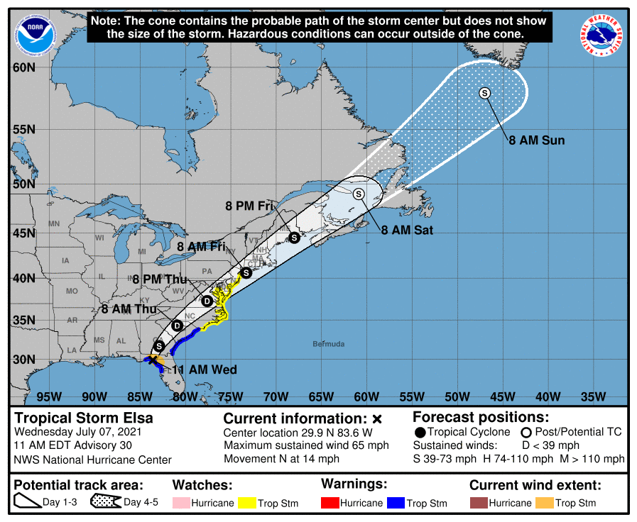
* STORM INFORMATION:
– About 830 miles southwest of Atlantic City NJ or about 780
miles southwest of Dover DE
– 29.9N 83.6W
– Storm Intensity 65 mph
– Movement North or 360 degrees at 14 mph
SITUATION OVERVIEW
—————–
Tropical Storm Elsa will make landfall along the west coast of Florida
later this morning and then track northeast through Georgia into the
Carolinas later tonight into Thursday morning. Elsa is then forecast to
move across southern Delaware and eastern New Jersey late Thursday
night into Friday morning. Elsa is then forecast to continue to
accelerate and move northeast, away from New Jersey, late Friday
morning.
The main threats with this system are heavy rainfall resulting in
flash flooding as well as some river flooding, as well as tropical
storm force winds, especially near the coast. In addition, dangerous
marine conditions will occur, along with the potential for dangerous
rip currents.
One to three inches of rainfall are forecast Thursday afternoon into
Friday morning. Heavy rainfall will result in a threat of localized
flash flooding. Dangerous marine conditions are also expected to
develop along the Delaware Bay waters south of Slaughter Beach and
along the Atlantic Coastal Waters for all of Delaware and up towards
Sandy Hook, NJ. Tropical Storm force winds will be most likely across
the waters with seas building to 6 to 9 feet. Dangerous rip currents
will likely occur along the ocean beaches of Delaware and New Jersey.
