About Scott Wahl

This author has not yet filled in any details.
So far Scott Wahl has created 253 blog entries.

Friday, July 10th, 8:28am: Flash Flood Warning Issued for Stone Harbor

Flash Flood Warning

Flash Flood Warning  NJC009-101815-  /O.NEW.KPHI.FF.W.0017.200710T1220Z-200710T1815Z/  /00000.0.ER.000000T0000Z.000000T0000Z.000000T0000Z.OO/    BULLETIN - EAS ACTIVATION REQUESTED  Flash Flood Warning  National Weather Service Mount Holly NJ  820 AM EDT Fri Jul 10 2020    The National Weather Service in Mount Holly NJ has issued a    * Flash Flood Warning for...    Southwestern Cape May County in southern New Jersey...    * Until 215 PM EDT.    * At 820 AM EDT, Doppler radar indicated heavy rain falling across    the warned area. Up to two inches of rain have already fallen.    Flash flooding is already occurring.      HAZARD...Life threatening flash flooding. Heavy rain producing             flash flooding.      SOURCE...Radar indicated.      IMPACT...Life threatening flash flooding of creeks and streams,             urban areas, highways, streets and underpasses.    * Some locations that could experience flooding include...    Cape May, North Wildwood, Wildwood Crest, Sea Isle City, Avalon,    West Cape May, Stone Harbor, Cape May Court House, Scotch Bonnet,    Diamond Beach, Green Creek, Goshen, Strathmere, Rio Grande, North    Cape May, Villas, West Wildwood, Erma and Whitesboro-Burleigh.    PRECAUTIONARY/PREPAREDNESS ACTIONS...    Protecting yourself from immediate threats to life and safety shall  take priority.  Whenever possible, as long as it does not cause  greater harm, all COVID-19 protective action guidance should be  followed.    Turn around...don`t drown when encountering flooded roads. Most flood  deaths occur in vehicles.    A Flash Flood Warning means that flooding is imminent or occurring.  If you are in the warned area move to higher ground immediately.  Residents living along streams and creeks should take immediate  precautions to protect life and property.

Friday, July 10th, 8:28am: Flash Flood Warning Issued for Stone Harbor2020-07-10T08:29:38-04:00

Friday, July 10th, 7:14am: Tropical Storm Warning Continues for Stone Harbor

Friday, July 10th, 7:14am: Tropical Storm Warning Continues for Stone Harbor2020-07-10T07:14:36-04:00

Thursday, July 9th, 5:31pm: Tropical Storm Warning Issued for Stone Harbor, Southern NJ Coastline

The National Weather Service has issued a Tropical Storm Warning for Stone Harbor and southern coastal New Jersey.  This is an elevation of the Flash Flood Watch that was issued earlier today by the Service.  Tropical Storm Fay has developed in the Atlantic Ocean and will have a direct impact on our community.

The Tropical Storm Warning remains in effect until further notice.  The warning means tropical storm conditions are expected locally over the next 36 hours.  This may include heavy rain, tropical storm force winds, rough surf, rip currents, and the potential for street flooding from heavy rainfall.

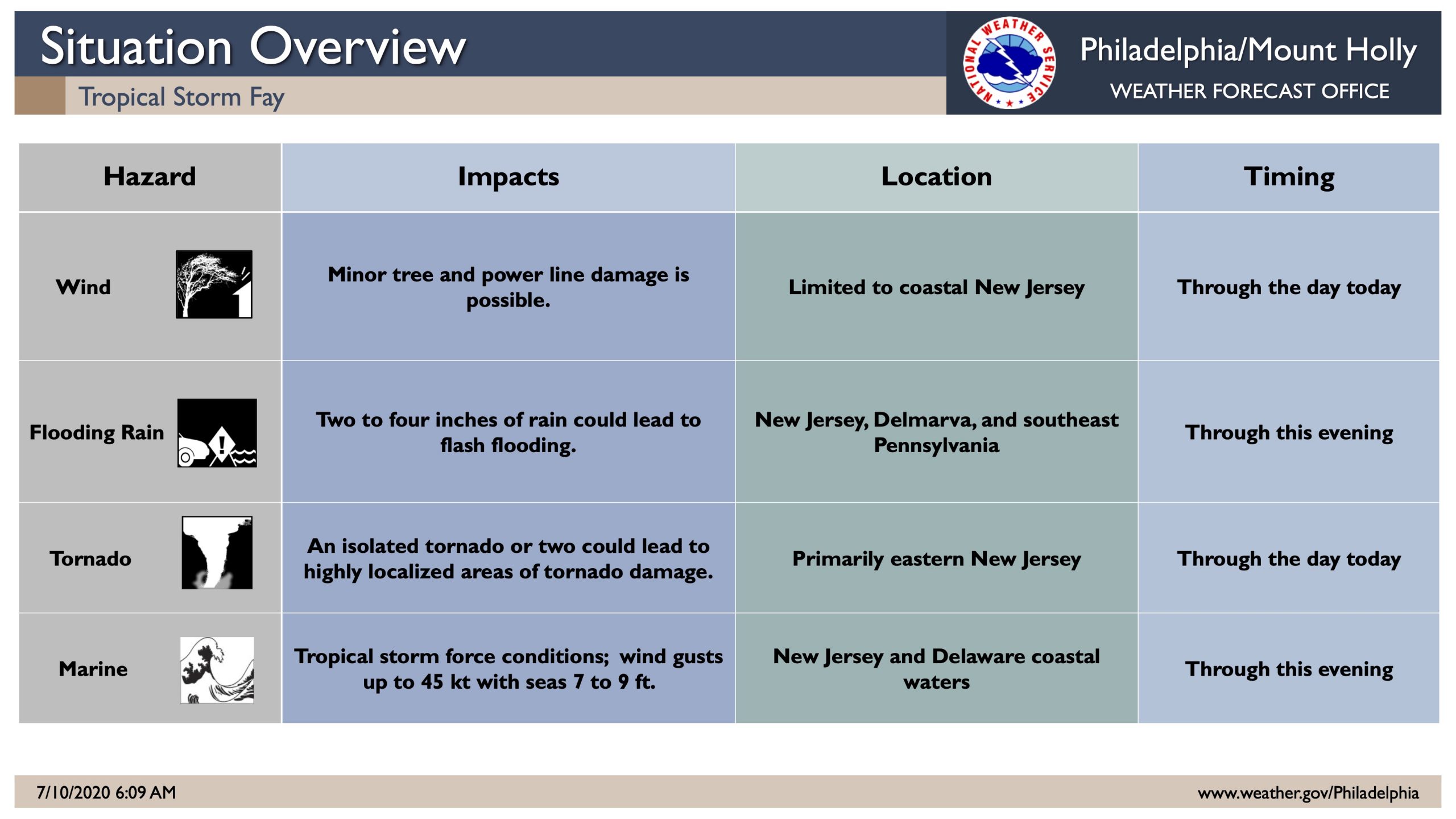
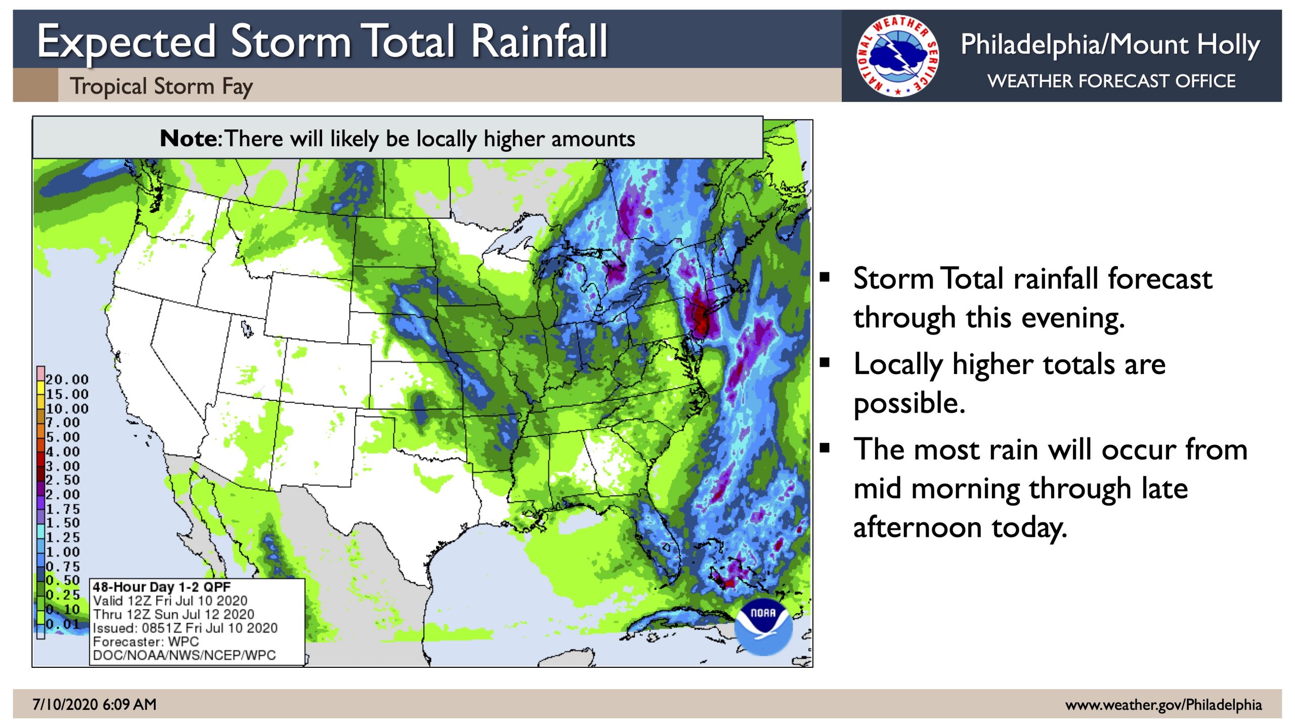
The potential exists for winds of 35-45mph with gusts approaching 50mph at times.  Tropical storm force winds are possible through Friday afternoon.  Peak rainfall amounts are expected between two to four inches, with locally higher amounts in some locations.  Rip currents along the beaches are also expected.

Please be prepared to move your vehicle to higher ground if you live in an area of our community that often floods during heavy rainfall events.  Never drive on any flooded street or intersection as this puts you and your vehicle at risk, and causes a wake that can damage private or public property.

If you have any outside objects that are prone to strong winds, bring them inside.  These may include trash cans, umbrellas, and light patio furniture.  Contractors are asked to secure their job sites immediately and secure any loose objects.

Please continue to monitor this storm event on our various media channels, and continue to follow updates on traditional media outlets.

Here is the latest advisory from the National Weather Service:

Tropical Storm Warning

Fay Local Watch/Warning Statement/Advisory Number 1

National Weather Service Mount Holly NJ  AL062020

506 PM EDT Thu Jul 9 2020


NJZ024-100515-

/O.NEW.KPHI.TR.W.1006.200709T2106Z-000000T0000Z/

Atlantic Coastal Cape May-

506 PM EDT Thu Jul 9 2020


…TROPICAL STORM WARNING IN EFFECT…


A Tropical Storm Warning means tropical storm-force winds are

expected somewhere within this area within the next 36 hours


* LOCATIONS AFFECTED

– Cape May

– Wildwood


* WIND

– LATEST LOCAL FORECAST: Equivalent Tropical Storm force wind

– Peak Wind Forecast: 35-45 mph with gusts to 50 mph

– Window for Tropical Storm force winds: until Friday

afternoon


– THREAT TO LIFE AND PROPERTY THAT INCLUDES TYPICAL FORECAST

UNCERTAINTY IN TRACK, SIZE AND INTENSITY: Potential for wind 39

to 57 mph

– PLAN: Plan for hazardous wind of equivalent tropical storm

force.

– PREPARE: Last minute efforts to protect property should now

be complete. The area remains subject to limited wind

damage.

– ACT: Now is the time to shelter from hazardous wind.


– POTENTIAL IMPACTS: Unfolding

– Potential impacts from the main wind event are unfolding.


* STORM SURGE

– LATEST LOCAL FORECAST: Not available at this time. To be

updated shortly.


– THREAT TO LIFE AND PROPERTY THAT INCLUDES TYPICAL FORECAST

UNCERTAINTY IN TRACK, SIZE AND INTENSITY: Not available at this

time. To be updated shortly.


– POTENTIAL IMPACTS: Not available at this time. To be updated

shortly.


* FLOODING RAIN

– LATEST LOCAL FORECAST: Flash Flood Watch is in effect

– Peak Rainfall Amounts: 2-4 inches, with locally higher

amounts


– THREAT TO LIFE AND PROPERTY THAT INCLUDES TYPICAL FORECAST

UNCERTAINTY IN TRACK, SIZE AND INTENSITY: Potential for

localized flooding rain

– PLAN: Emergency plans should include the potential for

localized flooding from heavy rain.

– PREPARE: Consider protective actions if you are in an area

vulnerable to flooding.

– ACT: Heed any flood watches and warnings.


– POTENTIAL IMPACTS: Limited

– Localized rainfall flooding may prompt a few evacuations.

– Rivers and tributaries may quickly rise with swifter

currents. Small streams, creeks, canals, arroyos, and

ditches may become swollen and overflow in spots.

– Flood waters can enter a few structures, especially in

usually vulnerable spots. A few places where rapid ponding

of water occurs at underpasses, low-lying spots, and poor

drainage areas. Several storm drains and retention ponds

become near-full and begin to overflow. Some brief road and

bridge closures.


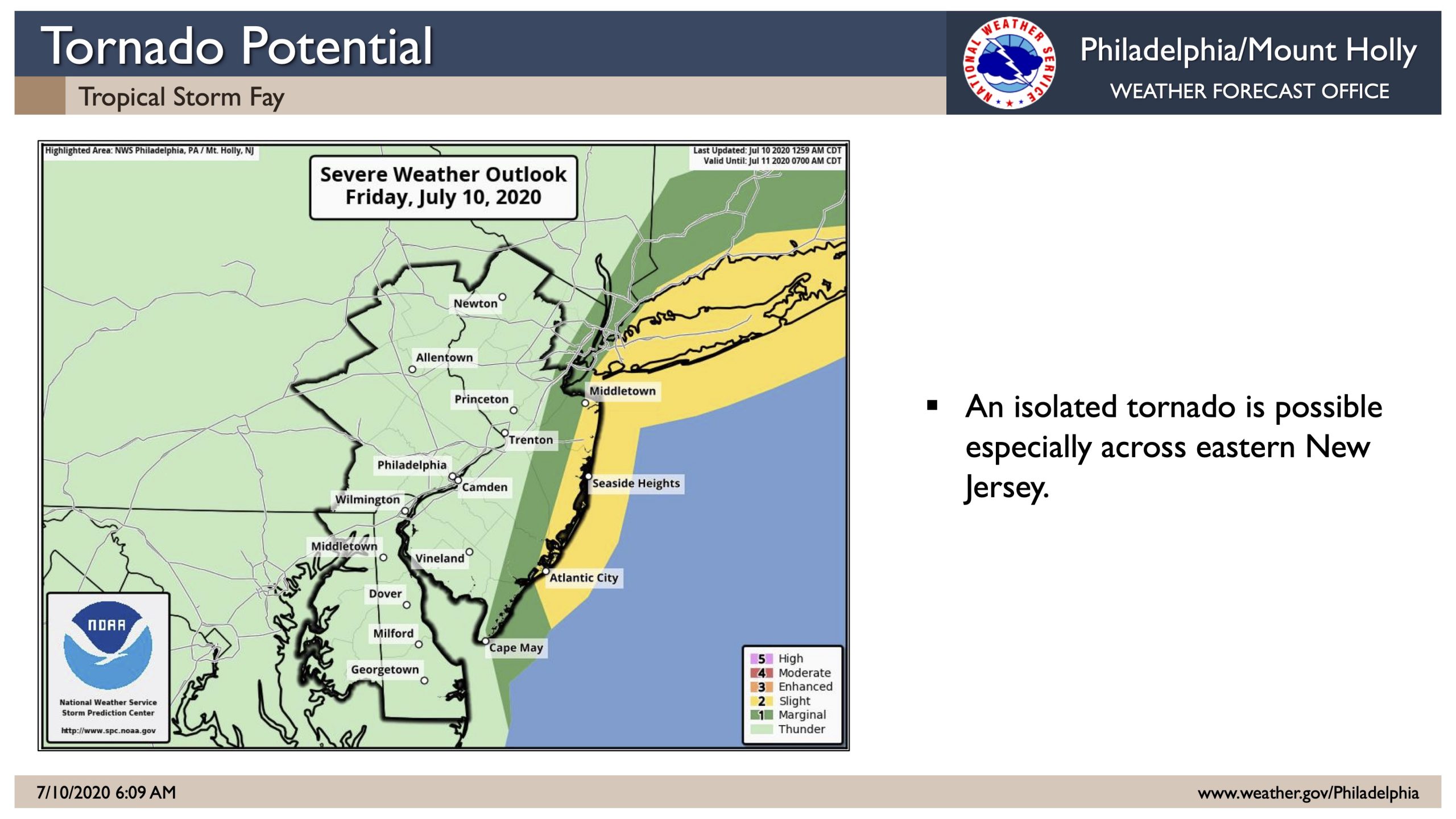
* TORNADO

– LATEST LOCAL FORECAST:

– Situation is somewhat favorable for tornadoes


– THREAT TO LIFE AND PROPERTY THAT INCLUDES TYPICAL FORECAST

UNCERTAINTY IN TRACK, SIZE AND INTENSITY: Potential for a few

tornadoes

– PLAN: Emergency plans should continue to include possible

tornadoes.

– PREPARE: Stay within your shelter keeping informed of the

latest tornado situation.

– ACT: Move quickly to the safest place within your shelter

if a tornado warning is issued.


– POTENTIAL IMPACTS: Limited

– The occurrence of isolated tornadoes can hinder the

execution of emergency plans during tropical events.

– A few places may experience tornado damage, along with

power and communications disruptions.

– Locations could realize roofs peeled off buildings,

chimneys toppled, mobile homes pushed off foundations or

overturned, large tree tops and branches snapped off,

shallow-rooted trees knocked over, moving vehicles blown

off roads, and small boats pulled from moorings.


* FOR MORE INFORMATION:

– http://www.capemaycountyemergency.net


$$


Hurricane Local Statement

Tropical Storm Fay Local Statement Advisory Number 1

DEZ001>004-MDZ008-012-015-019-020-NJZ010-012>027-PAZ070-071-102-104-106-100530-


Tropical Storm Fay Local Statement Advisory Number 1

National Weather Service Mount Holly NJ  AL062020

517 PM EDT Thu Jul 9 2020


This product covers NEW JERSEY…DELAWARE…SOUTHEASTERN PENNSYLVANIA AND NORTHEAST MARYLAND


**Tropical Storm Fay to Approach the New Jersey Coast**


NEW INFORMATION

—————


* CHANGES TO WATCHES AND WARNINGS:

– A Tropical Storm Warning has been issued for Atlantic, Atlantic

Coastal Cape May, Cape May, Coastal Atlantic, Coastal Ocean,

Eastern Monmouth, Middlesex, Ocean, Southeastern Burlington,

and Western Monmouth


* CURRENT WATCHES AND WARNINGS:

– A Tropical Storm Warning is in effect for Atlantic, Atlantic

Coastal Cape May, Cape May, Coastal Atlantic, Coastal Ocean,

Eastern Monmouth, Middlesex, Ocean, Southeastern Burlington,

and Western Monmouth


* STORM INFORMATION:

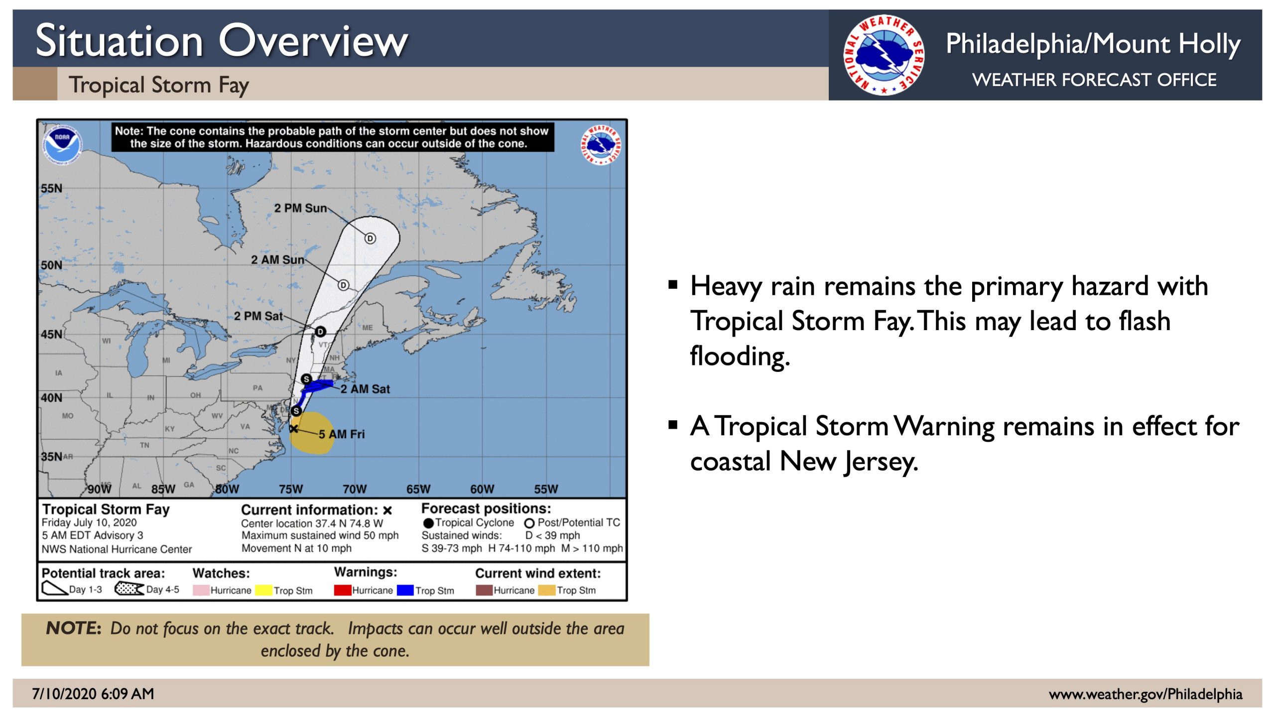
– About 270 miles south of Atlantic City NJ or about 240 miles

south of Cape May NJ

– 35.5N 74.9W

– Storm Intensity 45 mph

– Movement North or 360 degrees at 7 mph


SITUATION OVERVIEW

——————


Heavy rain leading to flooding will be possible, especially

along and southeast of the Interstate 95 corridor due to Tropical

Storm Fay. Tropical Storm Fay is currently off the Outer Banks. It

is expected to progress north over our region through Friday. Heavy

rain is possible beginning very late tonight and continuing through

Friday evening. The threat for tropical storm winds over land is

very low except right along the New Jersey coast.


POTENTIAL IMPACTS

—————–


* FLOODING RAIN:

Protect against locally hazardous rainfall flooding having possible

limited impacts along and southeast Interstate 95 corridor. Potential

impacts include:

– Localized rainfall flooding may prompt a few evacuations.

– Rivers and tributaries may quickly rise with swifter currents.

Small streams, creeks, canals, arroyos, and ditches may become

swollen and overflow in spots.

– Flood waters can enter a few structures, especially in usually

vulnerable spots. A few places where rapid ponding of water

occurs at underpasses, low-lying spots, and poor drainage

areas. Several storm drains and retention ponds become

near-full and begin to overflow. Some brief road and bridge

closures.


* TORNADOES:

Protect against a tornado event having possible limited impacts across

New Jersey… and southeastern Pennsylvania. Potential impacts

include:

– The occurrence of isolated tornadoes can hinder the execution

of emergency plans during tropical events.

– A few places may experience tornado damage, along with power

and communications disruptions.

– Locations could realize roofs peeled off buildings, chimneys

toppled, mobile homes pushed off foundations or overturned,

large tree tops and branches snapped off, shallow-rooted trees

knocked over, moving vehicles blown off roads, and small boats

pulled from moorings.


* WIND:

Protect against hazardous wind having possible limited impacts across

coastal New Jersey. Potential impacts in this area include:

– Damage to porches, awnings, carports, sheds, and unanchored

mobile homes. Unsecured lightweight objects blown about.

– Many large tree limbs broken off. A few trees snapped or

uprooted, but with greater numbers in places where trees are

shallow rooted. Some fences and roadway signs blown over.

– A few roads impassable from debris, particularly within urban

or heavily wooded places. Hazardous driving conditions on

bridges and other elevated roadways.

– Scattered power and communications outages.


Elsewhere across the region, little to no impact is anticipated.


PRECAUTIONARY/PREPAREDNESS ACTIONS

———————————-


* OTHER PREPAREDNESS INFORMATION:

Rapidly rising flood waters are deadly. If you are in a flood-prone

area, consider moving to higher ground. Never drive through a flooded

roadway. Remember, turn around don`t drown!


Closely monitor weather.gov, NOAA Weather radio or local news outlets

for official storm information. Be ready to adapt to possible changes

to the forecast. Ensure you have multiple ways to receive weather

warnings.


* ADDITIONAL SOURCES OF INFORMATION:

– For information on appropriate preparations see ready.gov

– For information on creating an emergency plan see getagameplan.org

– For additional disaster preparedness information see redcross.org


NEXT UPDATE

———–


The next local statement will be issued by the National Weather

Service in Mount Holly NJ around 11 PM, or sooner if conditions

warrant.


$$


Hazardous Weather Outlook

Hazardous Weather Outlook

National Weather Service Mount Holly NJ

312 PM EDT Thu Jul 9 2020


DEZ004-NJZ024-025-101915-

Delaware Beaches-Atlantic Coastal Cape May-Coastal Atlantic-

312 PM EDT Thu Jul 9 2020


…FLASH FLOOD WATCH IN EFFECT FROM MIDNIGHT EDT TONIGHT THROUGH

FRIDAY AFTERNOON…

…HIGH RIP CURRENT RISK IN EFFECT FROM FRIDAY MORNING THROUGH

FRIDAY EVENING…


This Hazardous Weather Outlook is for southern Delaware and

southern New Jersey.


.DAY ONE…This afternoon and tonight.


Please listen to NOAA Weather Radio or go to weather.gov on the

Internet for more information about the following hazards.


Flash Flood Watch.


.DAYS TWO THROUGH SEVEN…Friday through Wednesday.


Please listen to NOAA Weather Radio or go to weather.gov on the

Internet for more information about the following hazards.


Flash Flood Watch.

High Rip Current Risk.


The National Hurricane Center is currently monitoring Invest 98L as

a potential tropical cyclone. This low pressure system is currently

forecast to track close to the region and could bring heavy rain.

Localized minor tidal flooding is possible.


We are currently forecasting a high risk of dangerous rip currents

on Friday, and this may extend into the weekend.


.SPOTTER INFORMATION STATEMENT…


Weather spotters are encouraged to report significant weather

conditions according to standard operating procedures.


Thursday, July 9th, 5:31pm: Tropical Storm Warning Issued for Stone Harbor, Southern NJ Coastline2020-07-09T17:32:35-04:00

Thursday, July 9th, 3:28pm: Flash Flood Watch Issued for Stone Harbor

The National Weather Service has issued a Flash Flood Watch for Stone Harbor and the rest of southern New Jersey due to a developing low pressure system that is expected to move up the eastern seaboard over the next 48 hours.  This system may become a tropical system and could bring heavy rain, wind, rip currents, and some coastal flooding to our community.

The Flash Flood Watch is in effect at midnight on Friday, July 10th through 4:00pm, on July 10th.  There is the potential for one to three inches of rain, with higher amounts possible, during this storm.  Heavy rain may occur in a brief period of time which can cause street flooding until the rain water drains from the streets.  Never drive on a flooded street or through a flooded intersection as this puts you and your vehicle at risk, and causes an unnecessary wake that can damage property.

If you live in a section of Stone Harbor where street flooding is common during heavy rainfall events, you are advised to consider moving your vehicle to a different part of the community.

The Stone Harbor Office of Emergency Management is in continual contact with the Cape May County Office of Emergency Management and New Jersey State Police regarding this weather event.  Continue to monitor our media channels and traditional media outlets for updates when necessary

Flash Flood Watch

Flood Watch  National Weather Service Mount Holly NJ  300 PM EDT Thu Jul 9 2020      DEZ002>004-MDZ012-015-019-020-NJZ021>025-100700-  /O.NEW.KPHI.FF.A.0004.200710T0400Z-200710T2000Z/  /00000.0.ER.000000T0000Z.000000T0000Z.000000T0000Z.OO/  Kent-Inland Sussex-Delaware Beaches-Kent MD-Queen Annes-Talbot-  Caroline-Cumberland-Atlantic-Cape May-Atlantic Coastal Cape May-  Coastal Atlantic-  Including the cities of Dover, Georgetown, Rehoboth Beach,  Chestertown, Centreville, Easton, Denton, Millville, Hammonton,  Cape May Court House, Ocean City, and Atlantic City  300 PM EDT Thu Jul 9 2020    ...FLASH FLOOD WATCH IN EFFECT FROM MIDNIGHT EDT TONIGHT THROUGH  FRIDAY AFTERNOON...    The National Weather Service in Mount Holly has issued a    * Flash Flood Watch for portions of Delaware, northeast    Maryland, and southern New Jersey, including the following    areas, in Delaware, Delaware Beaches, Inland Sussex, and Kent.    In northeast Maryland, Caroline, Kent MD, Queen Annes, and    Talbot. In southern New Jersey, Atlantic, Atlantic Coastal    Cape May, Cape May, Coastal Atlantic, and Cumberland.    * From midnight EDT tonight through Friday afternoon    * Heavy rain associated with a coastal low is expected to start    late tonight and continue through Friday morning. Widespread    amounts of 1 to 3 inches are likely with locally higher amounts    possible.      PRECAUTIONARY/PREPAREDNESS ACTIONS...    A Flash Flood Watch means that there is the potential for flash  flooding which can be life-threatening. Heavy rain is expected to  occur over a short period of time. Rapidly rising flood waters  may quickly inundate roadways and areas of poor drainage. Streams  and creeks could leave their banks, flooding nearby properties.    Please monitor the forecast, especially if you live in a location  that is prone to flooding. Be prepared to take action if a flash  flood warning is issued for your area.  
Thursday, July 9th, 3:28pm: Flash Flood Watch Issued for Stone Harbor2020-07-09T15:31:16-04:00

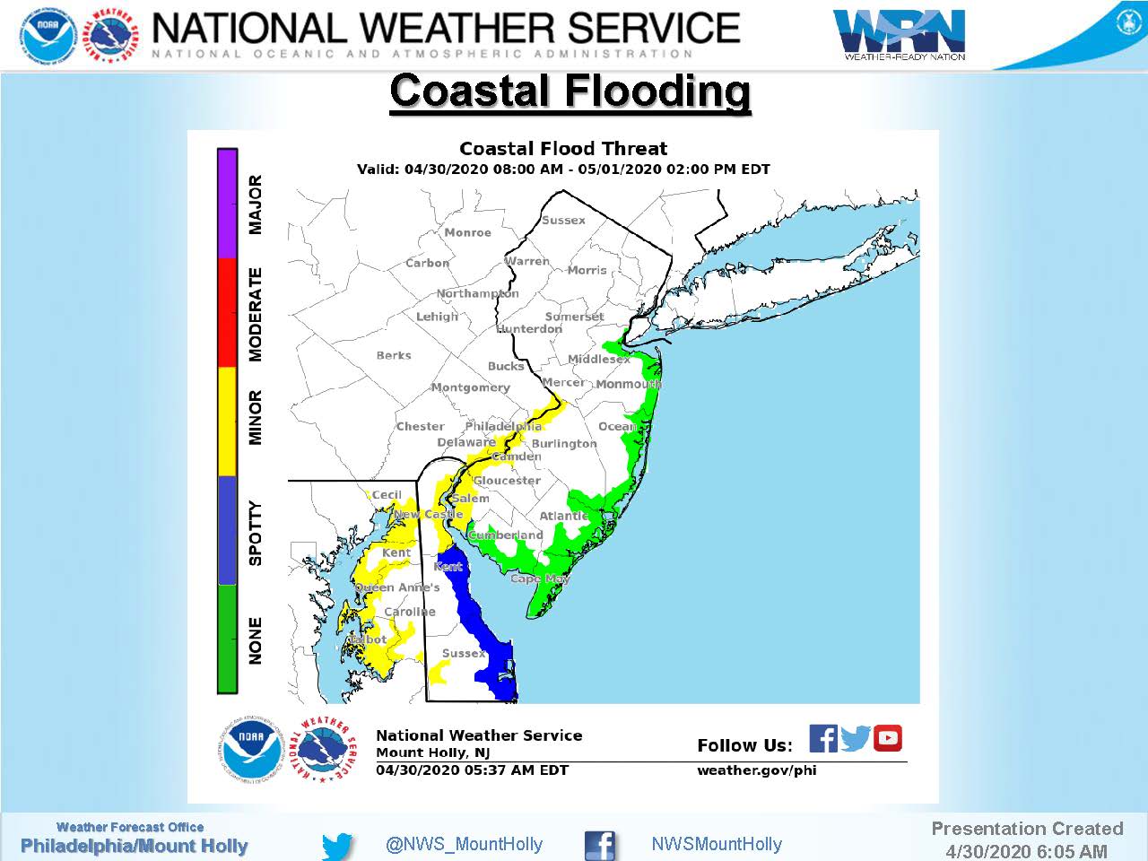
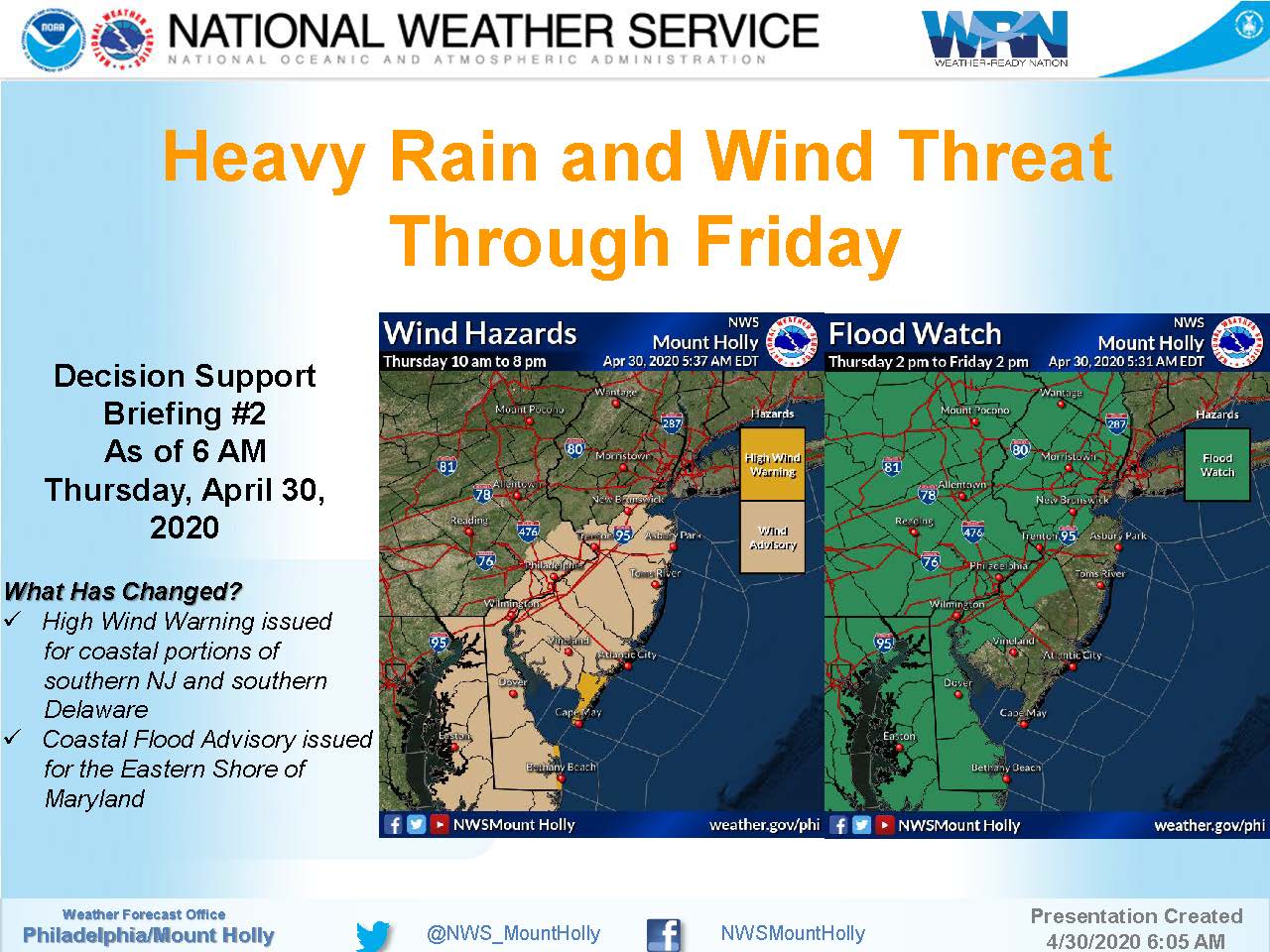
Thursday, April 30th: High Wind Warning in Effect for Storm Event

Thursday, April 30th: High Wind Warning in Effect for Storm Event2020-04-30T08:11:46-04:00

Monday, April 13th, 11:52am: Tornado Watch Issued, High Wind Warning Continues

The National Weather Service has issued a Tornado Watch for Stone Harbor and surrounding areas.  The Watch is in effect on Monday, April 13th, until 6:00pm.  A High Wind Warning continues for the community.

Strong winds continue to impact our region due to a storm system, and a cold front moving through our region later today.  The front may spark some heavy thunderstorms, strong gusty winds, and heavy rainfall.  If you see lightning or hear thunder, seek shelter immediately.  Never drive on a street that is flooded.

Remember, the Watch means that conditions are favorable for the development of a tornado.  A Warning means a tornado is imminent.  Continue to monitor traditional media outlets for updated information.  If you experience a power outage, contact Atlantic City Electric’s outage line at 1-800-833-7476.

Here is the text of the High Wind Warning updated late Monday morning by the National Weather Service:

High Wind Warning

URGENT - WEATHER MESSAGE  National Weather Service Mount Holly NJ      ...HIGH WIND WARNING REMAINS IN EFFECT UNTIL 7 PM EDT THIS  EVENING...    * WHAT...South winds 25 to 40 mph with 60 to 70 mph gusts    expected.    * WHERE...In New Jersey, Coastal Ocean, Atlantic Coastal Cape    May, Coastal Atlantic, Cape May, Eastern Monmouth, Western    Monmouth, Atlantic, Southeastern Burlington and Ocean. In    Delaware, Delaware Beaches.    * WHEN...Through 7 PM EDT this evening.    * IMPACTS...Damaging winds will blow down trees and power lines.    Widespread power outages are expected. Travel will be    difficult, especially for high profile vehicles.    * ADDITIONAL DETAILS...The strongest winds are forecast to occur    from late morning into the afternoon. Thunderstorms are    possible on Monday that could result in even stronger wind    gusts.    PRECAUTIONARY/PREPAREDNESS ACTIONS...    People should avoid being outside in forested areas and around  trees and branches. If possible, remain in the lower levels of  your home during the windstorm, and avoid windows. Use caution if  you must drive.
Monday, April 13th, 11:52am: Tornado Watch Issued, High Wind Warning Continues2020-04-13T11:53:04-04:00

Monday, April 13th, 10:45am: High Wind Warning Issued by National Weather Service

The National Weather Service has issued a High Wind Warning for the Borough of Stone Harbor.  The Warning remains in effect on Monday, April 13th, 2020 until 7:00pm.

Bands of heavy rain moved through our region during the overnight and morning hours.  Wind gusts may approach 65mph this afternoon as a squall line may develop and bring us stronger winds and the potential for downed trees and power outages.  If you have a power outage, please contact Atlantic City Electric at 1-800-833-7476.  Any remaining thunderstorms may cause heavy rainfall, do not drive on a flooded street for your safety.

Here is the text of the High Wind Warning from the National Weather Service:

High Wind Warning

URGENT - WEATHER MESSAGE  National Weather Service Mount Holly NJ  709 AM EDT Mon Apr 13 2020    DEZ004-NJZ013-014-020-022>027-132300-  /O.CON.KPHI.HW.W.0002.000000T0000Z-200413T2300Z/  Delaware Beaches-Western Monmouth-Eastern Monmouth-Ocean-Atlantic-  Cape May-Atlantic Coastal Cape May-Coastal Atlantic-Coastal Ocean-  Southeastern Burlington-  Including the cities of Rehoboth Beach, Freehold, Sandy Hook,  Jackson, Hammonton, Cape May Court House, Ocean City,  Atlantic City, Long Beach Island, and Wharton State Forest  709 AM EDT Mon Apr 13 2020    ...HIGH WIND WARNING REMAINS IN EFFECT UNTIL 7 PM EDT THIS  EVENING...    * WHAT...South winds 25 to 40 mph with 60 to 70 mph gusts    expected.    * WHERE...In New Jersey, Coastal Ocean, Atlantic Coastal Cape    May, Coastal Atlantic, Cape May, Eastern Monmouth, Western    Monmouth, Atlantic, Southeastern Burlington and Ocean. In    Delaware, Delaware Beaches.    * WHEN...Through 7 PM EDT this evening.    * IMPACTS...Damaging winds will blow down trees and power lines.    Widespread power outages are expected. Travel will be    difficult, especially for high profile vehicles.    * ADDITIONAL DETAILS...The strongest winds are forecast to occur    from late morning into the afternoon. Thunderstorms are    possible on Monday that could result in even stronger wind    gusts.    PRECAUTIONARY/PREPAREDNESS ACTIONS...    People should avoid being outside in forested areas and around  trees and branches. If possible, remain in the lower levels of  your home during the windstorm, and avoid windows. Use caution if  you must drive.
Monday, April 13th, 10:45am: High Wind Warning Issued by National Weather Service2020-04-13T10:48:40-04:00

Friday, Feb. 7th, 10:33am: Severe Thunderstorm Warning Issued for Stone Harbor

BULLETIN – IMMEDIATE BROADCAST REQUESTED
Severe Thunderstorm Warning
National Weather Service Mount Holly NJ
1010 AM EST Fri Feb 7 2020

The National Weather Service in Mount Holly NJ has issued a

* Severe Thunderstorm Warning for…
Atlantic County in southern New Jersey…
Cumberland County in southern New Jersey…
East central Salem County in southern New Jersey…
Ocean County in southern New Jersey…
Southeastern Camden County in southern New Jersey…
Southeastern Gloucester County in southern New Jersey…
Cape May County in southern New Jersey…
Burlington County in southern New Jersey…

* Until 1115 AM EST.

* At 1010 AM EST, severe thunderstorms were located along a line
extending from Olivet to near Fortesque to 7 miles northwest of
Lewes, moving northeast at 65 mph.

HAZARD…70 mph wind gusts and penny size hail.

SOURCE…Radar indicated.

IMPACT…Expect considerable tree damage. Damage is likely to
mobile homes, roofs, and outbuildings.

* Locations impacted include…
Toms River, Vineland, Atlantic City, Millville, Bridgeton, Ocean
City, Cape May, Cumberland, Lakewood, Jackson, Barnegat,
Pleasantville, Glassboro, Hammonton, Beachwood, Somers Point,
Ventnor City, Brigantine, Northfield and Absecon.

This includes the following highways…
Atlantic City Expressway between mile markers 0 and 40.
Garden State Parkway between mile markers 0 and 94.
Interstate 195 in New Jersey between mile markers 17 and 26.

PRECAUTIONARY/PREPAREDNESS ACTIONS…

For your protection move to an interior room on the lowest floor of a
building.

Intense thunderstorm lines can produce brief tornadoes and widespread
significant wind damage. Although a tornado is not immediately
likely, it is best to move to an interior room on the lowest floor of
a building. These storms may cause serious injury and significant
property damage.

Friday, Feb. 7th, 10:33am: Severe Thunderstorm Warning Issued for Stone Harbor2020-02-07T10:36:17-05:00

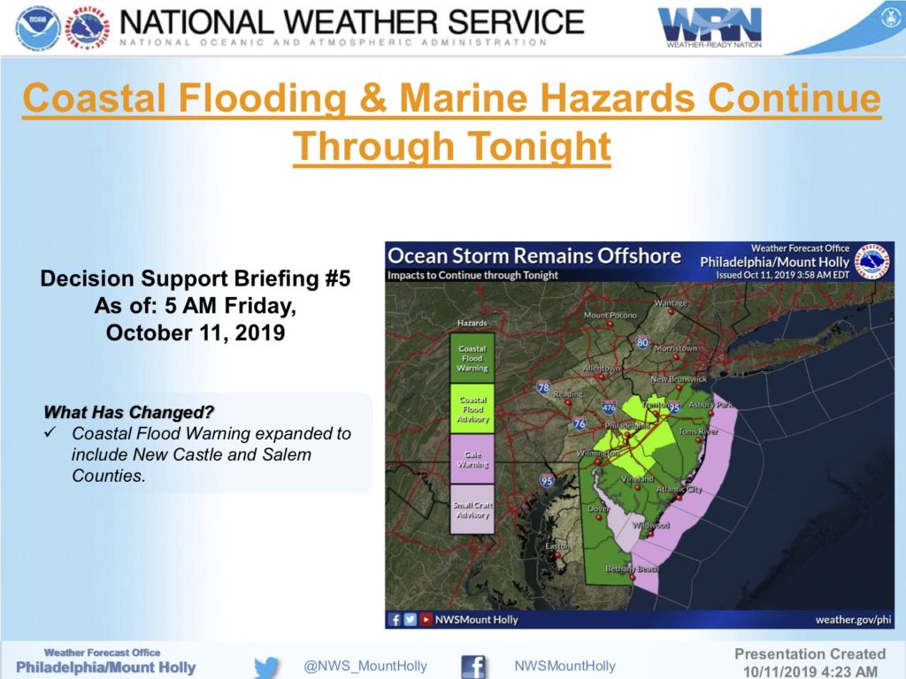
Friday, October 11th: Coastal Flood Warning, Moderate Coastal Flooding Expected

Flood warning graphic

The National Weather Service has continued the Coastal Flood Warning for our area through early Saturday morning, December 12th.  Moderate coastal flooding is anticipated at time of both high tides on Friday, and minor coastal flooding is anticipated for the high tide event on Saturday morning.

Our community received street flooding during Thursday evening’s high tide event. Never drive on any flooded street or through any flooded intersection as this puts you and your vehicle at risk, and creates an unnecessary wake that can damage private and public property.

High tide at the Townsend’s Inlet Bridge on Friday occurs at 7:15am, and again at 7:27pm. High tides on Saturday occur at 7:50am, and again at 8:04pm.  If you live in a flood prone section of our community, consider moving your vehicle to higher ground, especially during high tide events.

The Cape May County Office of Emergency Management continues to provide updates throughout the prolonged flooding event.

Here is the text of the Coastal Flood Warning issued Friday morning by the National Weather Service:

 Coastal Flood Warning

Coastal Hazard Message National Weather Service Mount Holly NJ 311 AM EDT Fri Oct 11 2019

…LONG DURATION COASTAL FLOOD EVENT TO CONTINUE INTO EARLY SATURDAY…COASTAL FLOOD WARNING REMAINS IN EFFECT UNTIL 1 AM EDT SATURDAY…

* LOCATIONS…In New Jersey, Atlantic Coastal Cape May, Coastal   Atlantic, Cape May and Atlantic. In Delaware, Delaware Beaches  and Inland Sussex.

* TIMING…Until 1 AM EDT Saturday.

COASTAL FLOOD IMPACTS…One to two feet of inundation above   ground level is possible in low-lying areas near shorelines and   tidal waterways. Back bays will have added water with previous  tide cycles not having drained completely.

PRECAUTIONARY/PREPAREDNESS ACTIONS…  A Coastal Flood Warning means that moderate or major tidal flooding is occurring or imminent. Be prepared for rising water levels and take appropriate action to protect life and property. Follow the recommendations of local emergency management officials.  Do not drive your vehicle through flood waters. The water may be deeper than you think it is. You will be putting yourself in danger and your vehicle may be damaged, leading to costly repairs.  Visit the Advanced Hydrologic Prediction Service at water.weather.gov/ahps for additional water level and flood impact information for your local tide gauge.
Friday, October 11th: Coastal Flood Warning, Moderate Coastal Flooding Expected2019-10-11T07:03:41-04:00

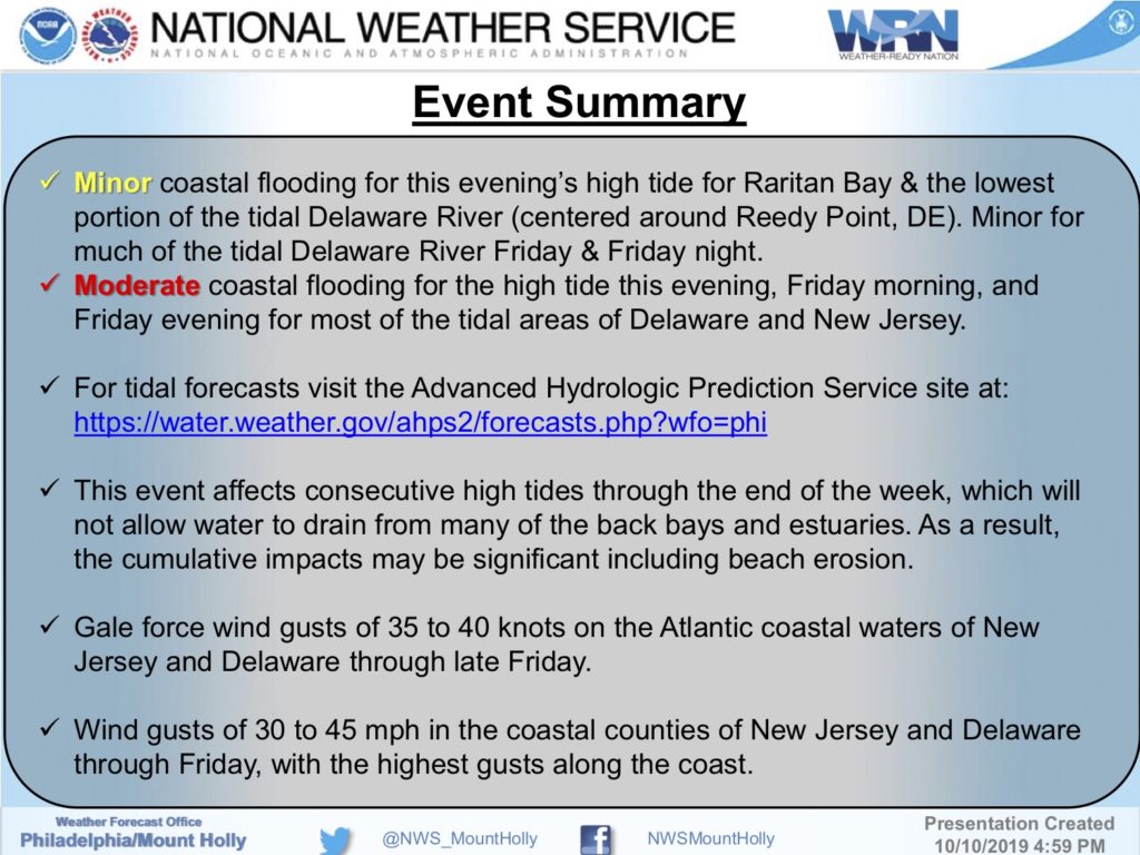
Thursday, October 10th: Coastal Flood Warning Continues Through Friday Evening

The National Weather Service has continued the Coastal Flood Warning for Stone Harbor and other coastal communities through the Friday evening high tide.  There is the expectation of moderate coastal flooding during high tide Thursday evening, Friday morning, and Friday evening, October 10-11.

A low pressure system has stacked water in the back bays with a strong wind that has not allowed the bays to drain during recent days.  The continued wind is expected to cause moderate tidal flooding, windy conditions, and possibly additional beach erosion through Friday evening.

High tide at the Townsend’s Inlet Bridge Thursday will occur at 6:48pm, and on Friday at 7:15am and again at 7:27pm.  Street flooding is expected in flood prone areas.  Do not attempt to drive on any flooded street.  Turn around, don’t drown.  If you live on a street that often experiences tidal flooding, you are advised to move your car to higher ground especially during high tide events.

Here is the text of the Coastal Flood Warning from the National Weather Service:

Coastal Flood Warning

Coastal Hazard Message National Weather Service Mount Holly NJ 432 PM EDT Thu Oct 10 2019  …LONG DURATION COASTAL FLOOD EVENT EXPECTED THROUGH FRIDAY… …COASTAL FLOOD WARNINGS HAVE BEEN ISSUED FOR SOME AREAS  …COASTAL FLOOD WARNING REMAINS IN EFFECT UNTIL 1 AM EDT SATURDAY…

* LOCATIONS…In New Jersey, Atlantic Coastal Cape May, Coastal   Atlantic, Cape May and Atlantic. In Delaware, Delaware Beaches  and Inland Sussex.  * TIMING…Until 1 AM EDT Saturday.

* COASTAL FLOOD IMPACTS…One to two feet of inundation above   ground level is possible in low-lying areas near shorelines   and tidal waterways.

PRECAUTIONARY/PREPAREDNESS ACTIONS…  A Coastal Flood Warning means that moderate or major tidal flooding is occurring or imminent. Be prepared for rising water levels and take appropriate action to protect life and property. Follow the recommendations of local emergency management officials.  Do not drive your vehicle through flood waters. The water may be deeper than you think it is. You will be putting yourself in danger and your vehicle may be damaged, leading to costly repairs.  Visit the Advanced Hydrologic Prediction Service at water.weather.gov/ahps for additional water level and flood impact information for your local tide gauge.  A Coastal Flood Advisory means that minor tidal flooding is expected. Minor tidal flooding often results in some road closures. Usually, the most vulnerable roadways will flood.  Do not leave your vehicle at a location that is prone to tidal flooding. Do not drive your vehicle through flood waters. The water may be deeper than you think it is. You will be putting yourself in danger and your vehicle may be damaged, leading to costly repairs.  Visit the Advanced Hydrologic Prediction Service at water.weather.gov/ahps for additional water level and flood impact information for your local tide gauge.

Thursday, October 10th: Coastal Flood Warning Continues Through Friday Evening2019-10-10T17:45:23-04:00
Go to Top