
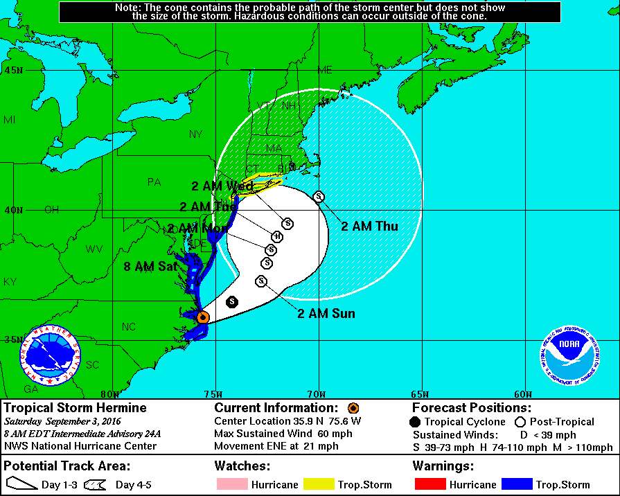
The National Weather Service has posted a Tropical Storm Warning for the Borough of Stone Harbor through Labor Day weekend. The Service provided its latest advisory to emergency management partners on Saturday, September 3rd, at 5:00am. As of 7:00am, rain was as close as Lewes, Delaware and winds are picking up on the 7 Mile Beach. The effects of Tropical Storm Hermine will be felt in our region starting on Saturday and lasting through Monday. The effects may include strong wind, rain, moderate coastal flooding, rough surf, beach erosion, and strong rip currents along the New Jersey coastline. Rain is expected to develop Saturday morning, and increase in intensity Saturday afternoon through Sunday. Stronger winds are possible Sunday into Sunday evening.
Computer models agree that the storm will move along the southeast coast and likely venture towards the east near the coastline of New Jersey. There is a potential for the storm to stall in the Atlantic Ocean and strengthen to a Category One hurricane which could prolong effects along our beaches, especially regarding rough surf and dangerous rip currents.
The Borough may experience minor to moderate coastal flooding at time of high tide especially Saturday evening and during the two high tide events on Sunday. High tide at the Townsend’s Inlet Bridge on Saturday, September 3rd will occur at 10:36am and again at 10:48pm; high tide will occur on Sunday, September 4th at 11:14am and again at 11:25pm. High tide will occur on Monday at 11:53am, and again Tuesday at 12:03am.
In advance of any flood advisory, watch, or warning, consider moving your vehicle to higher ground. Never park your vehicle on a bridge or traffic island. Street flooding may also occur during periods of heavy rainfall. Never attempt to drive your vehicle on any flooded street or through a flooded intersection as this puts you in danger and also creates an unnecessary wake that can damage private property and other vehicles. It is best that you shelter at your property during times of high tide; rising tidal flooding typically subsides within a couple of hours of a high tide along the back bay. If you have an emergency during the storm, please dial 911.
Please obey all instructions provided by the Stone Harbor Beach Patrol. Do not enter the ocean unless you are in the presence of an on-duty lifeguard. Do not enter the ocean before or after guards are on duty. Be aware that rip currents may take swimmers away from the water’s edge very quickly.
Never attempt to move any downed utility wire. If you have a power outage, please report the outage to Atlantic City Electric at 1-800-833-7476. Be sure to have your street address available to report the outage.
Secure any loose outdoor objects including trash cans/lids, umbrellas, patio furniture, and flags. Contractors have been told to secure their active job sites in advance of strong winds.
Stone Harbor will continue to provide alerts on our weather conditions at www.stoneharboremergency.com, Channel 97 for Comcast cable customers and when necessary, our Code Red emergency telephone call system. The Stone Harbor Farmers Market for Sunday has been cancelled.
Here is the latest advisory from the National Weather Service regarding Tropical Storm Hermine:
… Tropical Storm Warning remains in effect…
* locations affected
– Cape May
– Wildwood
* wind
– latest local forecast: equivalent tropical storm force wind
– peak wind forecast: 35-45 mph with gusts to 60 mph
– window for tropical storm force winds: Sunday morning until
Tuesday afternoon
– current threat to life and property: moderate
– the wind threat has remained nearly steady from the
previous assessment.
– Emergency plans should include a reasonable threat for
strong tropical storm force wind of 58 to 73 mph.
– To be safe, earnestly prepare for the potential of
significant wind impacts. Remaining efforts to secure
properties should now be brought to completion.
– Dangerous wind is possible. Failure to adequately shelter
may result in serious injury, or in some cases loss of
life. Move to safe shelter before the wind becomes
hazardous.
– Potential impacts: significant
– some damage to roofing and siding is likely, along with
damage to porches, awnings, carports, and sheds. A few
buildings will experience window, door, and garage door
failures. Mobile homes may be damaged, especially if
unanchored. Unsecured lightweight objects could become
airborne.
– Several large trees may be snapped or uprooted. Several
fences and roadway signs could be blown over.
– Some roads may be impassable from large debris. A few
bridges, causeways, and access routes may be impassable.
– There could be scattered power and communications outages,
but more prevalent in areas with above ground lines.
* Storm surge
– latest local forecast: life-threatening storm surge possible
– peak storm surge inundation: the potential for 2-4 feet
above ground somewhere within surge prone areas
– window of concern: begins this evening
– current threat to life and property: moderate
– the storm surge threat has remained nearly steady from the
previous assessment.
– Emergency considerations should posture for a reasonable
threat for dangerous storm surge flooding of greater than 3
feet above ground.
– To be safe, evacuees should be located within prescribed
shelters and well away from storm surge flooding capable of
significant impacts.
– Life threatening inundation is possible. Those who failed
to heed evacuation orders risk serious injury or loss of
life.
– Potential impacts: significant
– areas of inundation are possible with storm surge flooding
enhanced by waves. Damage is likely to several buildings,
mainly near the coast.
– Sections of near-shore escape routes and secondary roads could
become weakened or washed out, especially in usually vulnerable
low spots.
– Major beach erosion is expected with heavy surf breaching
dunes. Strong and numerous rip currents are expected.
– Moderate damage to marinas, docks, boardwalks, and piers is
anticipated. Several small craft may be broken away from
moorings, especially in unprotected areas.
* Flooding rain
– latest local forecast:
– peak rainfall amounts: 2-4 inches, with locally
higher amounts
– current threat to life and property: elevated
– the flooding rain threat has remained nearly steady from
the previous assessment.
– Emergency plans should include a reasonable threat for
minor flooding where peak rainfall totals are near amounts
conducive for localized flash flooding and rapid inundation.
– To be safe, prepare for the potential of limited flooding
rain impacts.
– Localized flooding is possible. If flood related watches
and warnings are issued, heed recommended actions.
– Potential impacts: limited
– localized rainfall flooding may prompt a few evacuations.
– Rivers and tributaries may quickly rise with swifter
currents. Small streams, creeks, canals, and ditches may
become swollen and overflow in spots.
– Flood waters can enter a few structures, especially in
vulnerable spots. Rapid ponding of water may occur at
underpasses, low-lying spots, and poor drainage areas.
Several storm drains and retention ponds become near-full
and begin to overflow. Some brief Road and bridge closures
are possible.
