Tues, March 20th, 5:15pm: Winter Storm Warning, Coastal Flood Warning Continue; Snow Expected Wednesday
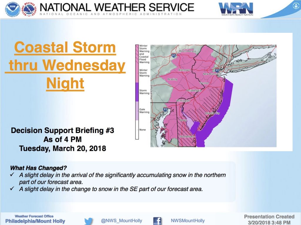
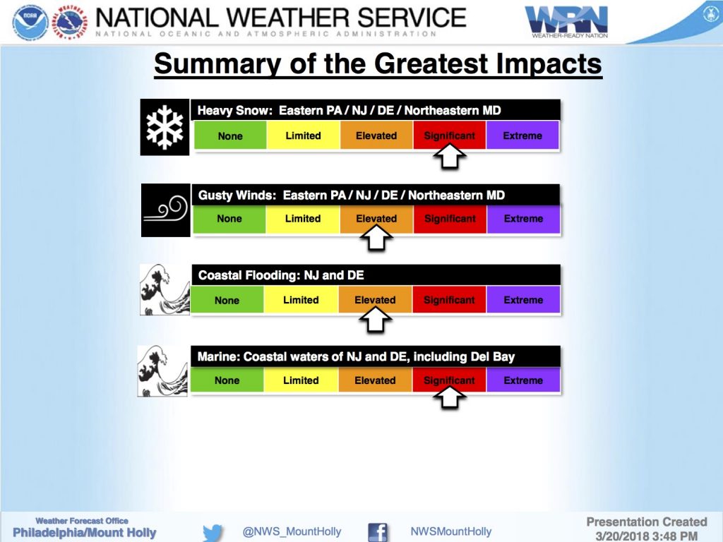
The National Weather Service has continued the Winter Storm Warning and the Coastal Flood Warning for the Borough through Wednesday evening, March 21st. The storm is expected to drop a few to several inches of snow on our region on Wednesday, and is anticipated to cause minor to moderate coastal flooding at time of high tide, especially during the two high tide cycles on Wednesday.
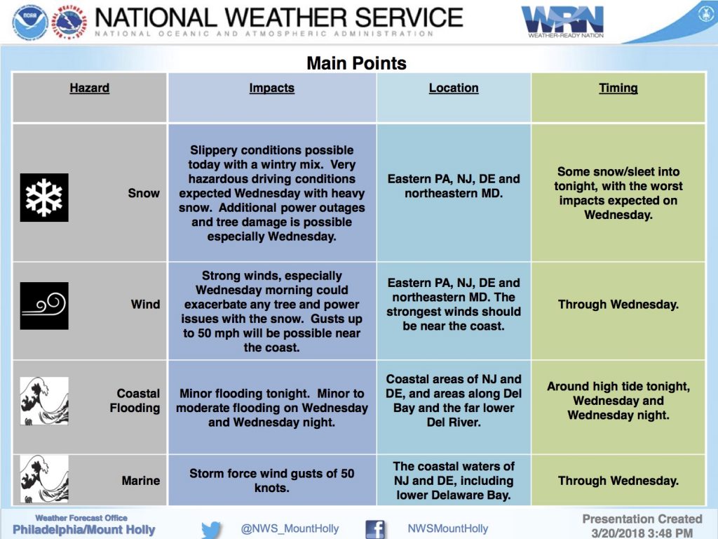
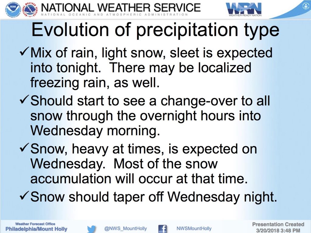
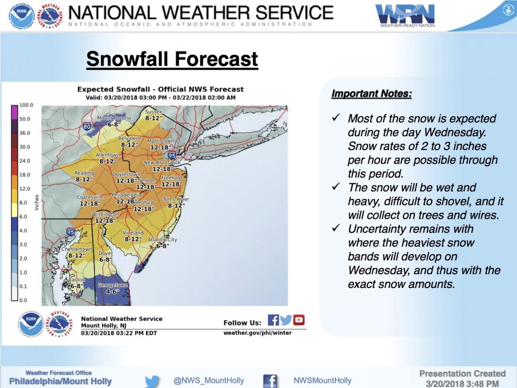
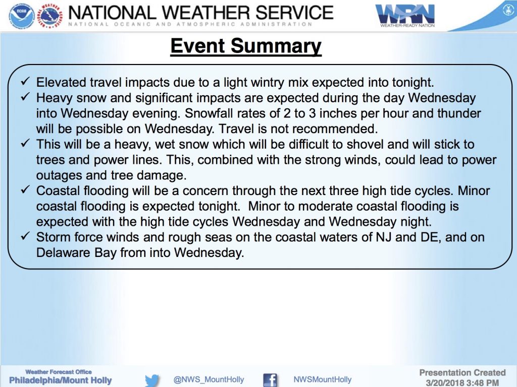
The winter storm has moved into our region with largely rain and wind along our coastline on Tuesday evening. There is expected to be a gradual transition to sleet and snow during the overnight and morning hours on Wednesday with a largely all-snow event Wednesday afternoon, into the evening hours. This snowfall is expected to make driving difficult Wednesday and Wednesday evening.
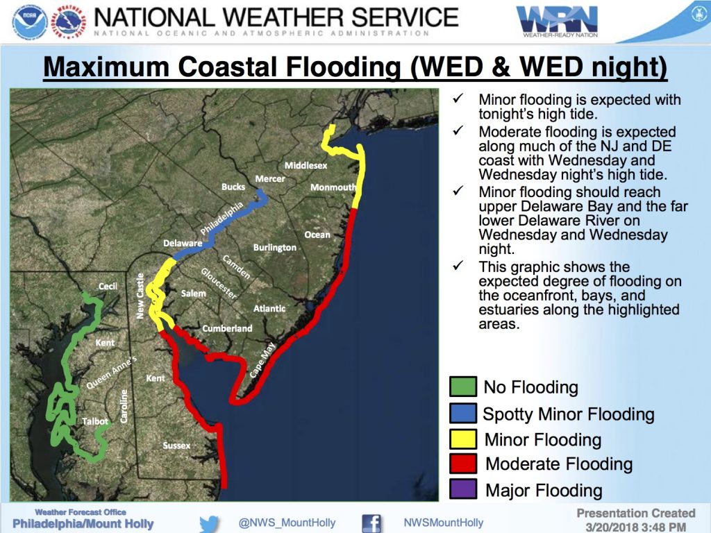
Minor coastal flooding is anticipated at time of high tide Tuesday evening, at 11:01pm. Moderate coastal flooding is anticipated at time of high tide on Wednesday at 11:25am and again at 11:47pm. The Wednesday morning high tide may produce the most severe coastal flooding during this storm event. Never attempt to drive on any street that is flooded; flooding on streets may be obstructed due to snow. If you live on a street that typically experiences flooding during coastal storms, consider moving your vehicle into your driveway or to another part of our community that typically does not flood.
Never attempt to move or drive over any utility wire. If you have a power outage, contact Atlantic City Electric directly at 1-800-833-7476. If you have any emergency, dial 911.
The Borough continues to remain in communication with the Cape May County Department of Emergency Management, and the New Jersey State Police. Continue to monitor updates in our community on this website, and continue to monitor updated weather forecasts from the National Weather Service on traditional media outlets.
Here is the text of the various warnings issued by the National Weather Service:
Winter Storm Warning
URGENT – WINTER WEATHER MESSAGE National Weather Service Mount Holly NJ 356 PM EDT Tue Mar 20 2018 …Major Coastal Storm to Affect the Region Through Wednesday Night… .A pair of low pressure systems to our south today will consolidate into an intense nor`easter just east of the mid-Atlantic coast on Wednesday, then pass southeast of Nantucket Island late Wednesday night. Unnecessary travel in most of New Jersey and eastern Pennsylvania Wednesday afternoon and evening is strongly discouraged!
…WINTER STORM WARNING NOW IN EFFECT FROM 6 AM WEDNESDAY TO 2 AM EDT THURSDAY…
* WHAT…Heavy mixed precipitation expected. Total snow accumulations of 5 to 8 inches, with localized amounts up to 12 inches, and ice accumulations of a light glaze are expected.
* WHERE…Portions of southeastern New Jersey, Maryland`s lower eastern shore, central and southern Delaware.
* WHEN…From 6 AM Wednesday to 2 AM EDT Thursday.
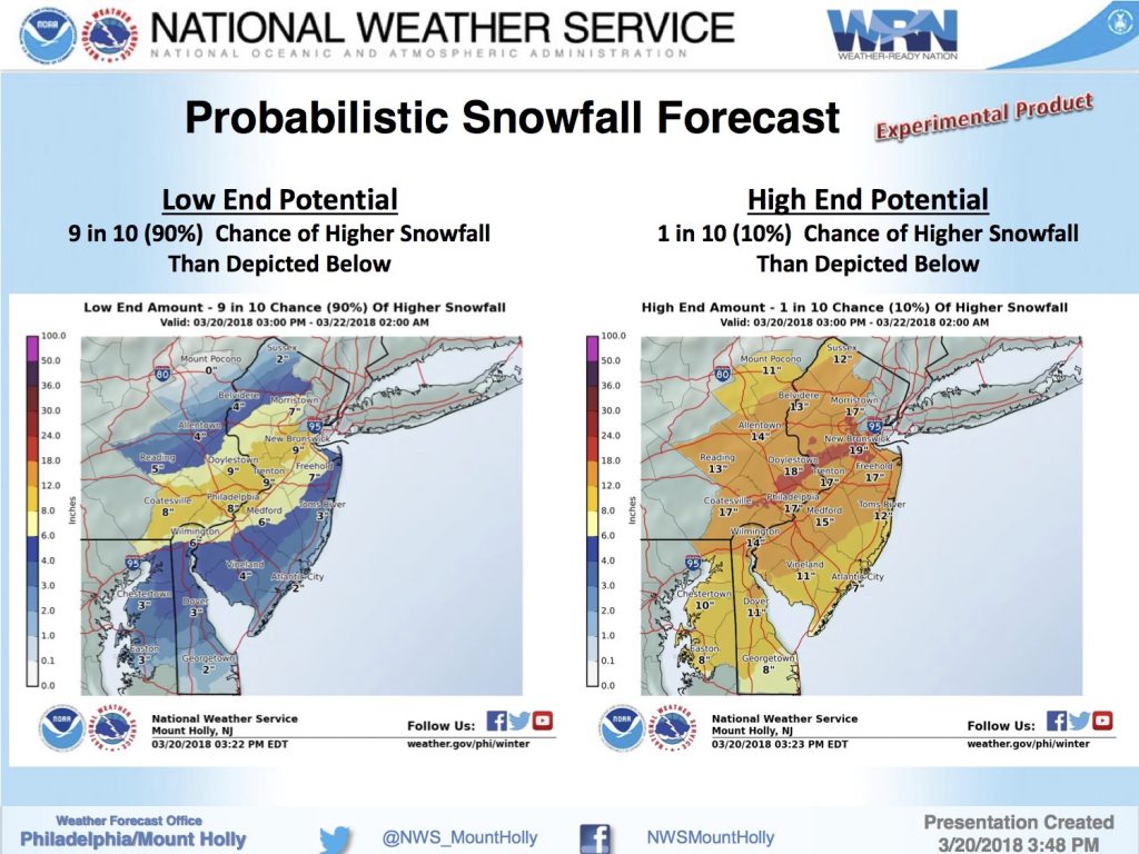
* ADDITIONAL DETAILS…Plan on difficult travel conditions, including during the evening commute on Wednesday. Tree branches could fall with widespread power outages possible Wednesday afternoon. Be prepared for significant reductions in visibility at times with snowfall rates approaching an inch an hour for a time. Glazing may begin toward dawn Wednesday away from the coast. Uncertainty exists regarding maximum storm total snow over 6 inches. Thundersnow is possible late morning and afternoon.
Coastal Flood Warning
COASTAL FLOOD WARNING REMAINS IN EFFECT FROM 8 PM THIS EVENING TO 5 AM EDT THURSDAY…
* LOCATIONS…Coastal areas of Cape May County and Cumberland County in New Jersey, and Sussex County and Kent County in Delaware.
* COASTAL FLOODING…Minor flooding is forecast with tonight`s high tide. Moderate flooding is expected with the high tides on Wednesday and Wednesday night.
* TIMING…Flooding may occur for a few hours around the time of high tide. High tide on the New Jersey and Delaware oceanfront occurs between 10:15 PM and 11:15 PM tonight, between 10:30 AM and 11:30 AM on Wednesday, and between 11:00 PM and midnight on Wednesday night. High tide on the back bays and on Delaware Bay occurs later than the high tide on the oceanfront.
* SURGE…Around 1.5 to 2.0 feet tonight, and around 2.5 to 3.0 feet on Wednesday and Wednesday night.
* WAVES…Around 12 to 18 feet off the coast tonight, around 10 to 15 feet on Wednesday, and around 6 to 10 feet on Wednesday night. * IMPACTS…Numerous roadways will flood and minor to moderate property damage is possible. The tide and wave action is expected to result in moderate beach erosion.
PRECAUTIONARY/PREPAREDNESS ACTIONS… This Coastal Flood Warning means that moderate tidal flooding is imminent. Be prepared for rising water levels and take appropriate action to protect life and property. Follow the recommendations of local emergency management officials. Do not drive your vehicle through flood waters. The water may be deeper than you think it is. You will be putting yourself in danger and your vehicle may be damaged, leading to costly repairs. Visit the Advanced Hydrologic Prediction Service at water.weather.gov/ahps for additional water level and flood impact information for your local tide gauge.