Thursday, February 13th Storm Alert for Stone Harbor

The National Weather Service issued a Coastal Flood Advisory in addition to a Winter Weather Advisory that is currently in effect for the Borough. The Coastal Flood Advisory is now in effect from Thursday, February 13th at 5:00am until Midnight Thursday. The potential exists for some minor coastal flooding at time of high tide on Thursday.
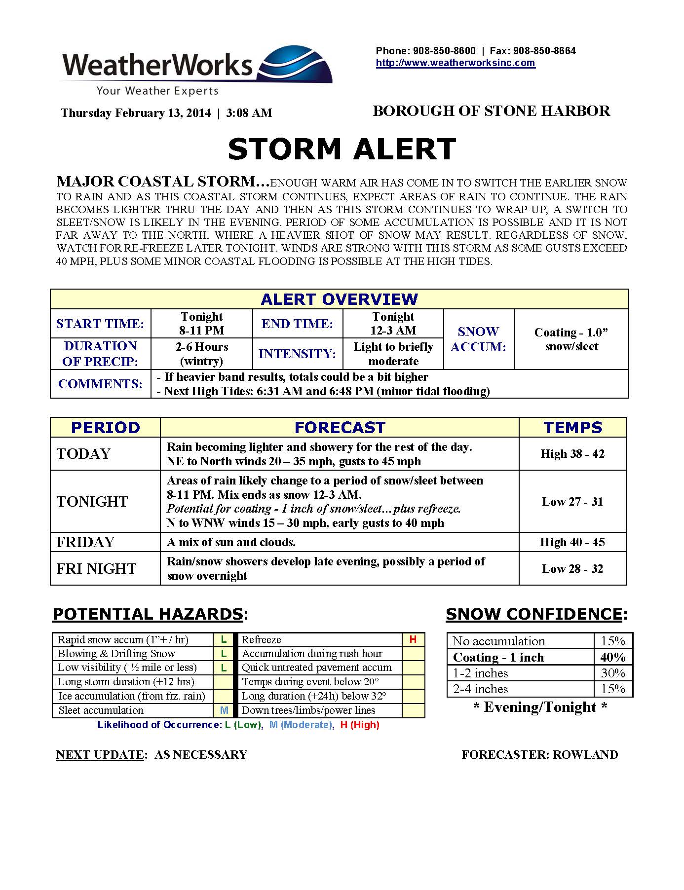
A major coastal storm continues to move up the eastern seaboard and will bring some snow, sleet, and rain to our region on Wednesday evening. The storm will continue into Thursday with rain likely, heavy at times, and very windy conditions. The storm could end with a short period of snow at the end. No major snow accumulations are expected during this storm with an inch to a few inches in the forecast. However, areas just north of Philadelphia could be getting a foot or more of heavy snow during this coastal winter storm event. The forecast has been a tricky one for forecasters, so please check the forecast on a regular basis until this storm is over. Please watch your driving and plan for a longer commute if you leave Cape May County on Thursday.
High tide at Stone Harbor, Great Channel on Thursday will be at 7:22am and again at 7:45pm. This is when areas that typically get flooding during minor coastal flooding events could see high water. Never attempt to drive through any standing water on the roadway as it puts yourself and your vehicle in danger. If you have an emergency, please dial 911. There is a potential for power outages throughout South Jersey during this storm event due to strong winds. Wind gusts during this storm could reach 45mph at any time on Thursday.
Please continue to monitor traditional local media outlets for additional information. Please remember that the forecast for our community is much different than the forecast for Philadelphia and northern New Jersey.
Here are the two advisories posted by the National Weather Serivce:
Winter Weather Advisory remains in effect from 7 PM this evening to 7 am EST Thursday…
* locations… the advisory includes Cape May County as well as the coastal portions of ocean and Atlantic counties in New Jersey and coastal Sussex County in Delaware.
* Hazard types… primarily snow and sleet.
* Accumulations… snow accumulation of up to 1 inch… along with around a trace of ice.
* Timing… the precipitation should begin as all snow tonight before changing over to a snow and sleet mix early Thursday morning. Thursday morning… precipitation is expected to be primarily rain.
* Impacts… travel could be significantly impacted across the region especially early Thursday morning. In addition to travel impacts… winds of 20 to 30 mph with gusts up to 40 mph will be possible on Thursday which could lead to power outages if there has been significant heavy snow accumulations on power lines by the time the winds increase.
Precautionary/preparedness actions…
A Winter Weather Advisory means that periods of snow… sleet… or freezing rain will cause travel difficulties. Be prepared for slippery roads and limited visibilities… and use caution while driving.
Statement as of 2:00 PM EST on February 12, 2014
… Coastal Flood Advisory in effect from 5 am Thursday to midnight EST Thursday night…
The National Weather Service in Mount Holly has issued a coastal Flood Advisory… which is in effect from 5 am Thursday to midnight EST Thursday night.
* Coastal flooding… areas of minor coastal flooding is expected with the Thursday morning and Thursday evening high tides.
* Timing… high tide along the New Jersey and Delaware ocean fronts occurs between 600 am and 800 am Thursday for the morning high tide, and 600 PM and 800 PM for the evening high tide. High tide on the back bays and Delaware Bay occur later than the high tide along the ocean front.
* Impacts… areas of poor drainage and roadway flooding is expected.
Precautionary/preparedness actions…
A coastal Flood Advisory indicates that minor tidal flooding is anticipated. Minor tidal flooding often results in some Road closures. Usually… the most vulnerable roadways will flood.
Do not leave your vehicle at a location that is prone to tidal flooding. Do not drive your vehicle through flood waters. The water may be deeper than you think it is. You will be putting yourself in danger and your vehicle may be damaged… leading to costly repairs.
The National Weather Service has issued a Winter Weather Advisory for the Borough for Wednesday, February 12th at 7pm through Thursday, February 13th, at 7:00am. This new advisory replaces a Winter Storm Watch that had been posted for our region.
A major coastal storm will move out of the south and up the eastern seaboard on Wednesday. The storm is expected to arrive Wednesday evening bringing a period of snow to our region before a changeover to a cold rainstorm. Strong winds will accompany the arrival of the storm. Winds overnight into Thursday morning are expected to be out of the northeast with gusts of 40mph. Rain will continue on Thursday morning through parts of Thursday afternoon with windy conditions. The storm could finish with a period of light snow on Thursday evening. No significant snow accumulations are expected from this storm in our community.
If you have to drive on Wednesday or Thursday, please be advised that areas just to our north and northwest are under Winter Storm Warnings with heavy wet accumulating snow likely from this storm. The Philadelphia region and parts north could be getting 6–12 inches of snow out of this system which will make traveling very difficult.
Now is a good time to bring in outdoor objects that could be subject to strong winds. There are currently no flood advisories, watches, or warnings issued by the National Weather Service but the forecast has been difficult for meteorologists and could change again overnight or Wednesday morning. Please continue to monitor local media outlets for the most up to date information regarding this nor’easter-type winter storm. If you have any emergency, please dial 9–1-1.
Here is the text of the Winter Weather Advisory issued by the National Weather Service:
Winter Weather Advisory in effect from 7 PM Wednesday to 7 am EST Thursday…
The National Weather Service in Mount Holly has issued a Winter Weather Advisory for snow and sleet… which is in effect from 7 PM Wednesday to 7 am EST Thursday. The Winter Storm Watch is no longer in effect.
* Locations… the advisory includes Cape May County as well as the coastal portions of ocean and Atlantic counties.
* Hazard types… primarily snow and sleet.
* Accumulations… snow accumulation of 1 to 2 inches.
* Timing… the precipitation should begin as all snow Wednesday night before changing over to a snow and sleet mix early Thursday morning. Thursday morning… precipitation is expected to be primarily rain.
* Impacts… travel could be significantly impacted across the region especially early Thursday morning. In addition to travel impacts… winds of 20 to 30 mph with gusts up to 40 mph will be possible on Thursday which could lead to power outages if there has been significant heavy snow accumulations on power lines by the time the winds increase.
Precautionary/preparedness actions…
A Winter Weather Advisory means that periods of snow… sleet… or freezing rain will cause travel difficulties. Be prepared for slippery roads and limited visibilities… and use caution while driving.
The National Weather Service has issued a Winter Storm Watch for the Borough and the rest of Cape May County for Wednesday evening through Thursday morning. A storm system is expected to bring some snow and rain and nor’easter-type conditions to our region Wednesday evening through Thursday morning. Travel could be difficult. Please continue to monitor traditional media outlets for updates in advance of this next winter storm.
Winter Storm Watch in effect from Wednesday evening through Thursday afternoon…
The National Weather Service in Mount Holly has issued a Winter Storm Watch… which is in effect from Wednesday evening through Thursday afternoon.
* Locations… the watch includes southeastern New Jersey… southern and central Delaware and much of the northern Maryland Eastern Shore.
* Hazard types… primarily snow and sleet.
* Accumulations… snow accumulation of 4 to 8 inches… the highest amounts are forecast to be inland.
* Timing… the precipitation should begin as all snow Wednesday night before changing over to a snow and sleet mix early Thursday morning. By mid day Thursday… precipitation is expected to be primarily rain
* impacts… travel could be significantly impacted across the region especially Thursday morning. In addition to travel impacts… winds of 15 to 25 mph with gusts up to 35 mph will be possible on Thursday which could lead to power outages if there has been significant heavy snow accumulations on power lines by the time the winds increase.
Precautionary/preparedness actions…
A Winter Storm Watch means there is a potential for significant snow… sleet… or ice accumulations that may impact travel. Continue to monitor the latest forecasts.