
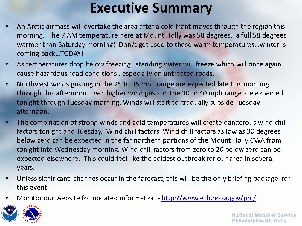
 The National Weather Service has posted a Wind Chill Advisory for our region for Tuesday, January 7th from 1:00am until 12 Noon. A front is pushing through our region on Monday that will bring cold, dry arctic air to our region. Temperatures will fall throughout the day on Monday into Monday night with very cold wind chill values for the morning commute on Tuesday. An executive summary of the weather conditions for South Jersey over the next 36 hours are included in the photo to the right; click on the photo for a larger version.
Please exercise extra caution while driving this evening through Tuesday. Much of the snowfall from the weekend has melted and roads and sidewalks could become very slippery with ice. Please bring your pets indoors to provide warmth and comfort. Check on elderly neighbors and relatives to make sure they have heat and are properly protected from the elements. Strong winds will accompany this front; bring in any loose objects that may become subject to strong winds.
Sunshine but with the possibility of freezing spray is in the forecast for Tuesday. Wind chill values locally could exceed -11 degrees, with wind gusts at times during Tuesday morning approaching 45mph. If you have an emergency, please dial 9-1-1.
Here is the complete report on weather conditions for South Jersey from the National Weather Service: National Weather Service Cold Weather Briefing Monday January 6 2014
Here is the text of the Wind Chill Advisory issued by the National Weather Service:
The National Weather Service has posted a Wind Chill Advisory for the Borough for the early parts of this week. Heavy rain was pushing through our community during mid morning hours on Monday. Behind the rain, colder air from the arctic that will result in very low wind chill values along the Jersey Shore. Here is the text of the Wind Chill Advisory posted by the National Weather Service:
Wind Chill Advisory in effect from 1 am to noon EST Tuesday…
The National Weather Service in Mount Holly has issued a Wind Chill Advisory. It is in effect from 100 am Tuesday until noon on Tuesday.
* Locations..extreme southeastern Pennsylvania, southern New Jersey, Delaware and northeastern Maryland.
* Hazard types… dangerous cold and wind.
* Wind chill values… .as low as minus 10 to minus 15.
* Timing… late tonight through midday Tuesday.
* Impacts… prolonged exposure to the dangerous cold and wind may lead to hypothermia and frostbite.
Precautionary/preparedness actions…
This Wind Chill Advisory means that the combination of very cold air and strong winds will create dangerously low wind chill values. Limit your time out of doors if possible.
