
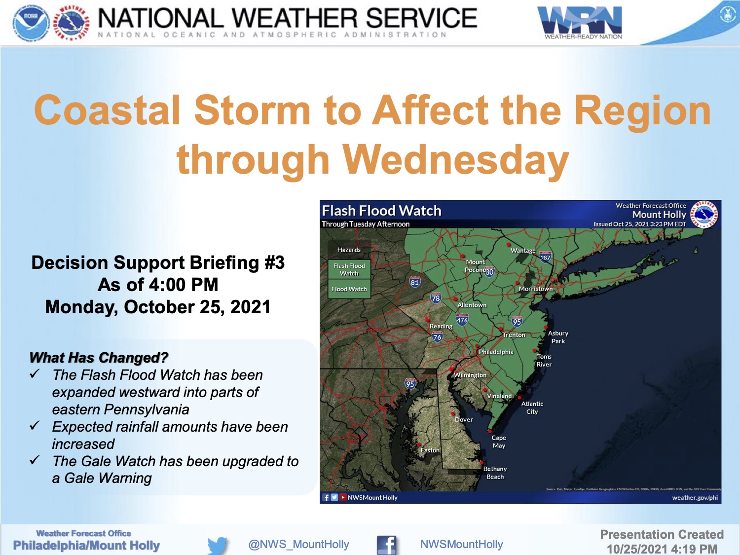
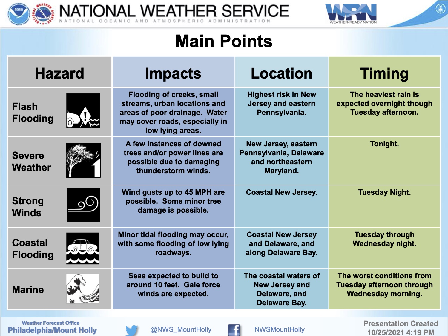
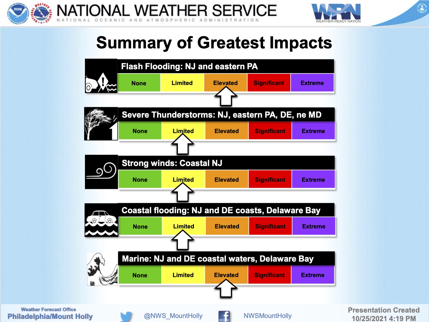
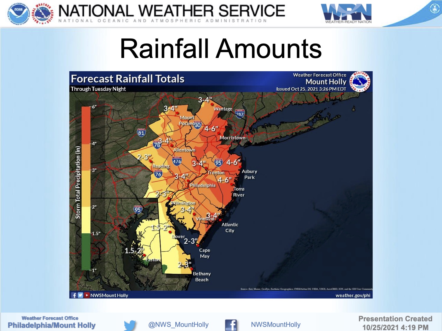
Sunday, October 10th, 8:13am: Coastal Flood Warning Issued for Stone Harbor
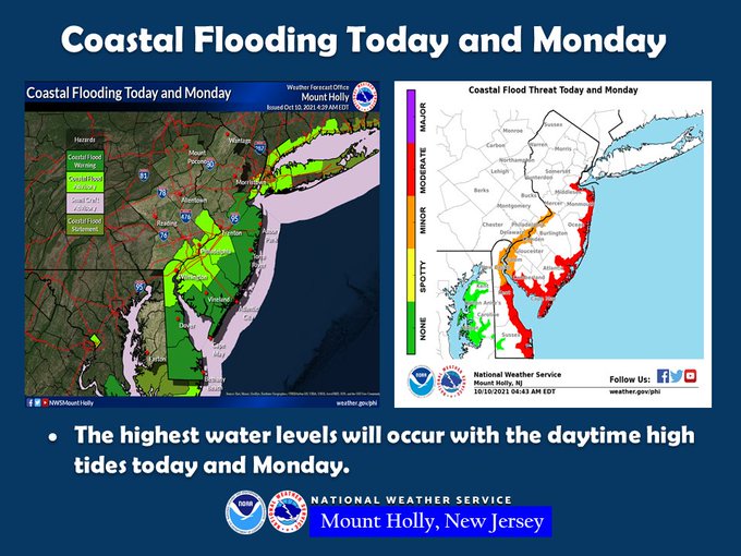
The National Weather Service has issued a Coastal Flood Warning for Stone Harbor and other barrier island communities. The warning is in effect until Monday, October 11th at 5:00pm. Moderate tidal flooding is expected at time of high tide Sunday and Monday, and minor tidal flooding is expected at time of high tide Sunday night. An onshore flow combined with a new moon may create one to two feet of flood inundation in flood prone areas.
High tide occurs at the Townsend’s Inlet Bridge Sunday at 11:33am and again at 11:59pm. High tide occurs Monday at 12:32pm.
Never attempt to drive your vehicle on any flooded street. Turn around, don’t drown. Driving your vehicle on a flooded street creates a wake that can damage your car along with private and public property.
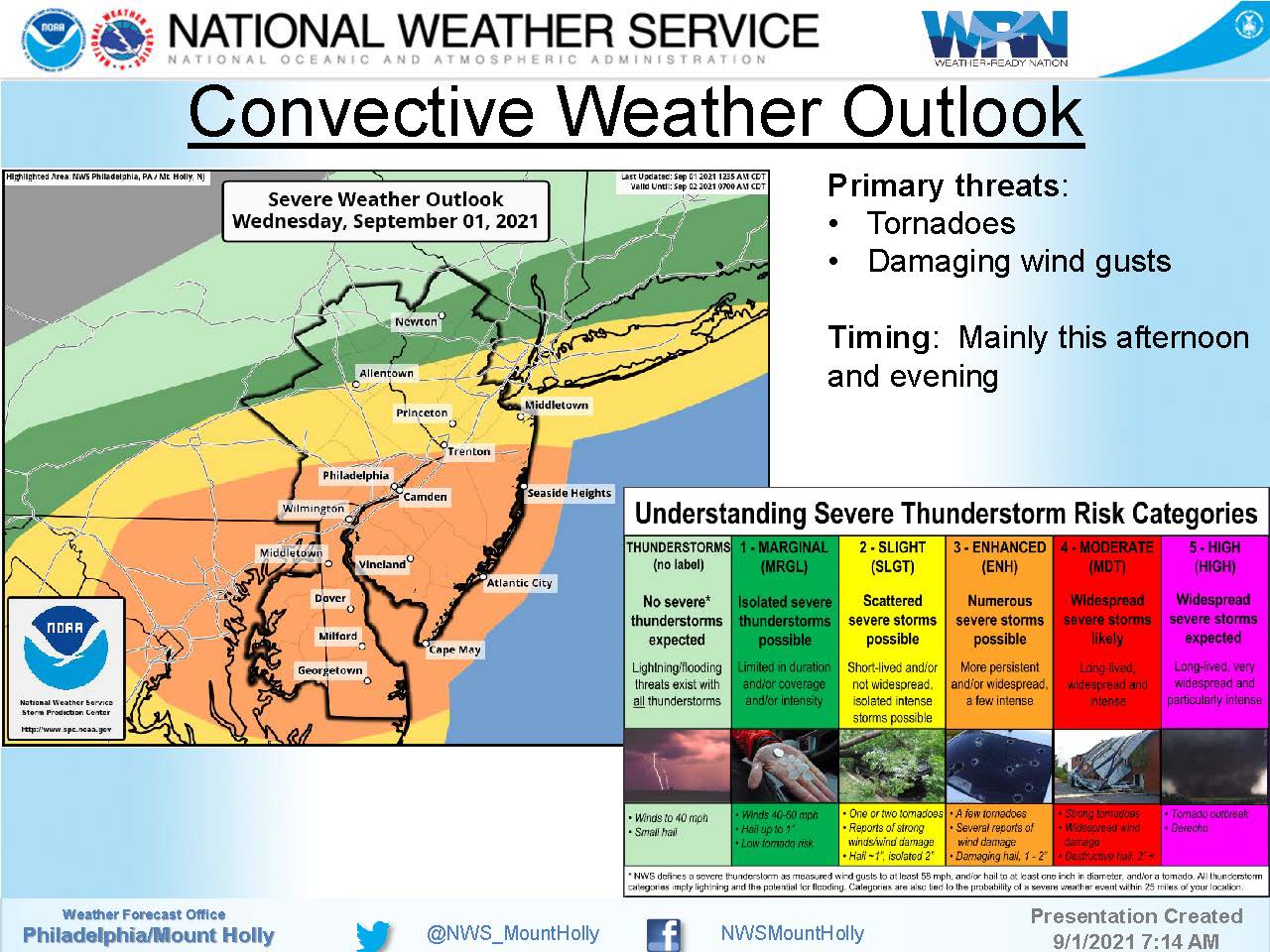
Wednesday, September 1st, 12:48pm: Tornado Watch Issued By National Weather Service
Tornado Watch
TORNADO WATCH OUTLINE UPDATE FOR WT 483 NWS STORM PREDICTION CENTER NORMAN OK 1240 PM EDT WED SEP 1 2021 TORNADO WATCH 483 IS IN EFFECT UNTIL 1000 PM EDT FOR THE FOLLOWING LOCATIONS NJC001-005-007-009-011-015-019-021-023-025-027-029-033-035-041- 020200- /O.NEW.KWNS.TO.A.0483.210901T1640Z-210902T0200Z/ NJ . NEW JERSEY COUNTIES INCLUDED ARE ATLANTIC BURLINGTON CAMDEN CAPE MAY CUMBERLAND GLOUCESTER HUNTERDON MERCER MIDDLESEX MONMOUTH MORRIS OCEAN SALEM SOMERSET WARREN
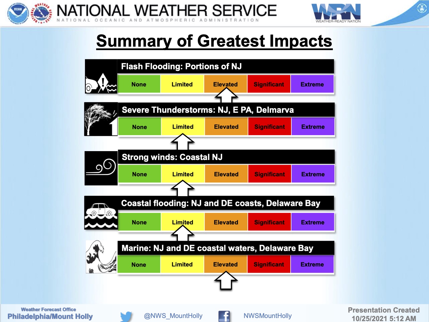
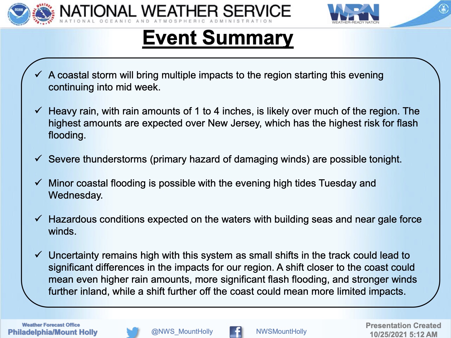
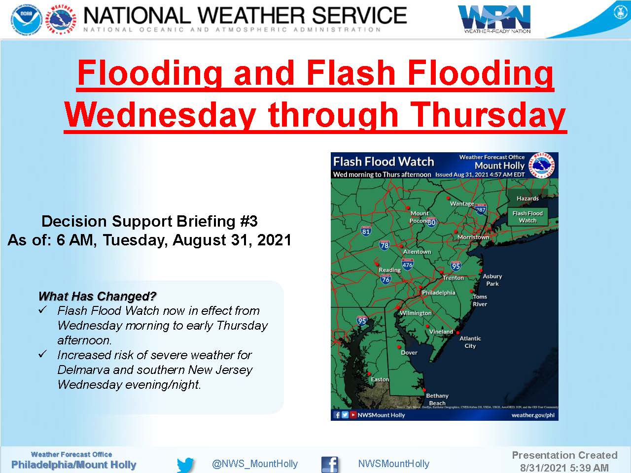
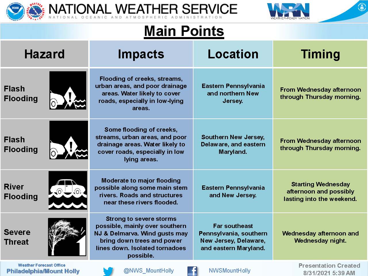
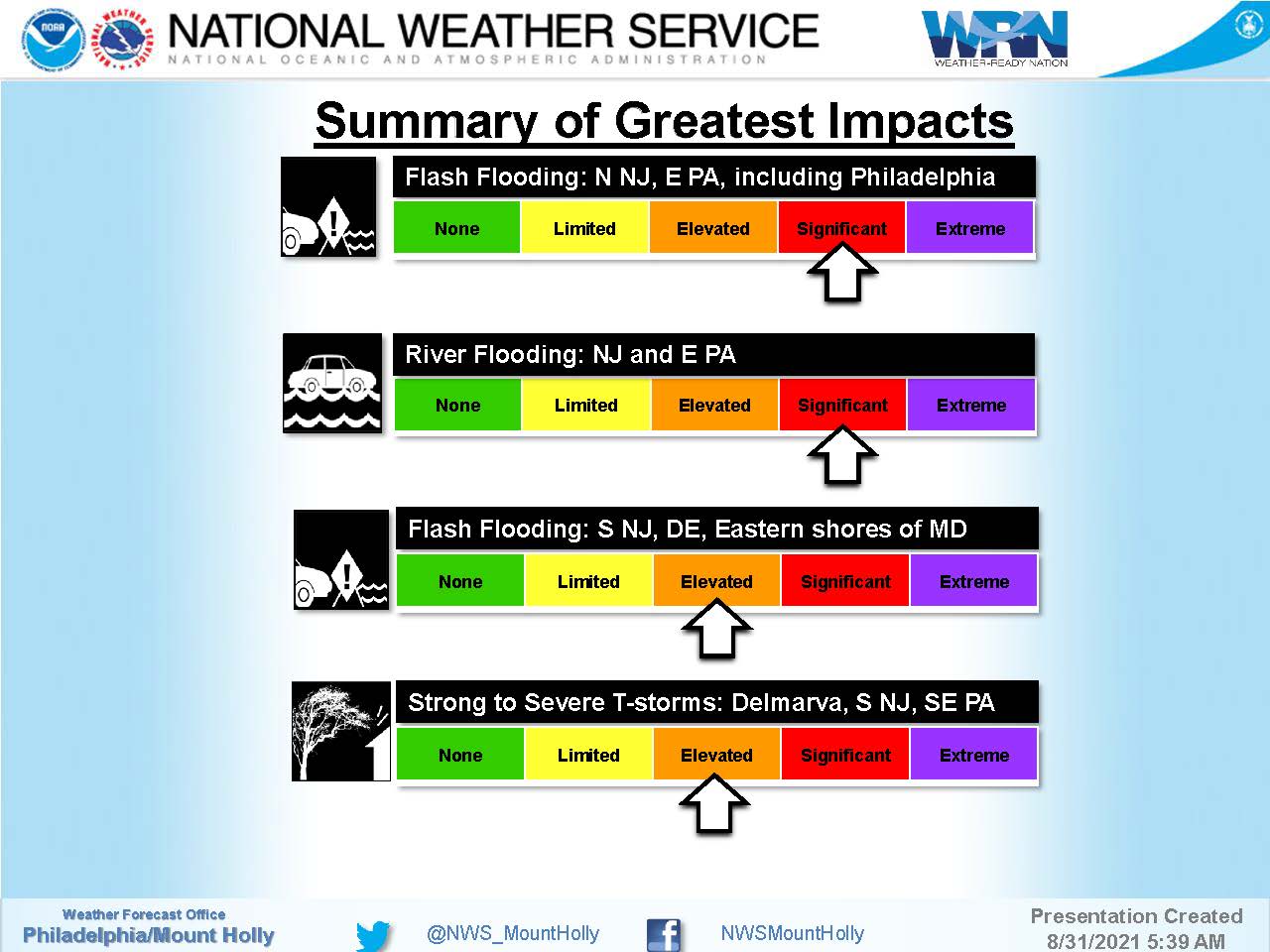
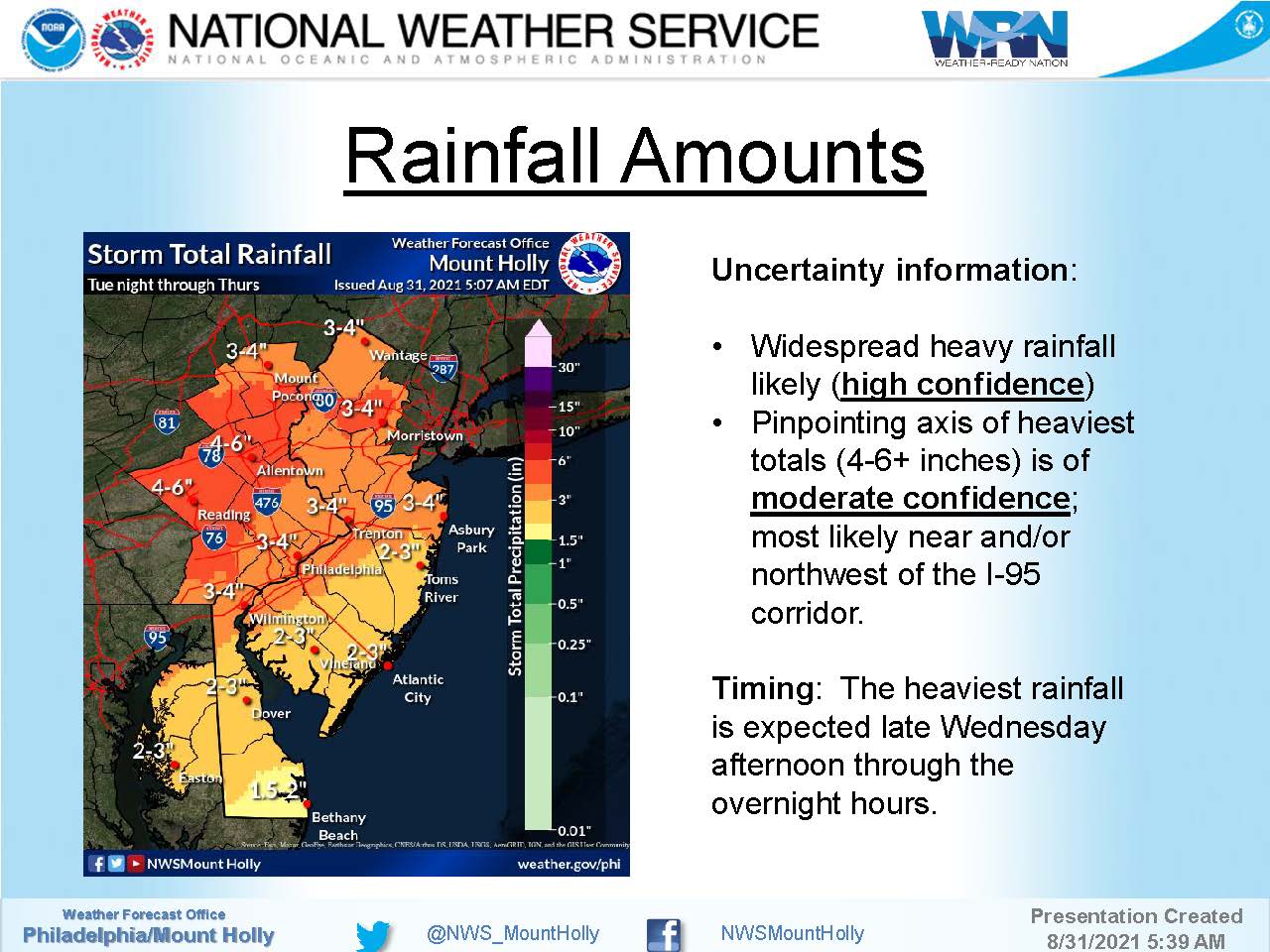
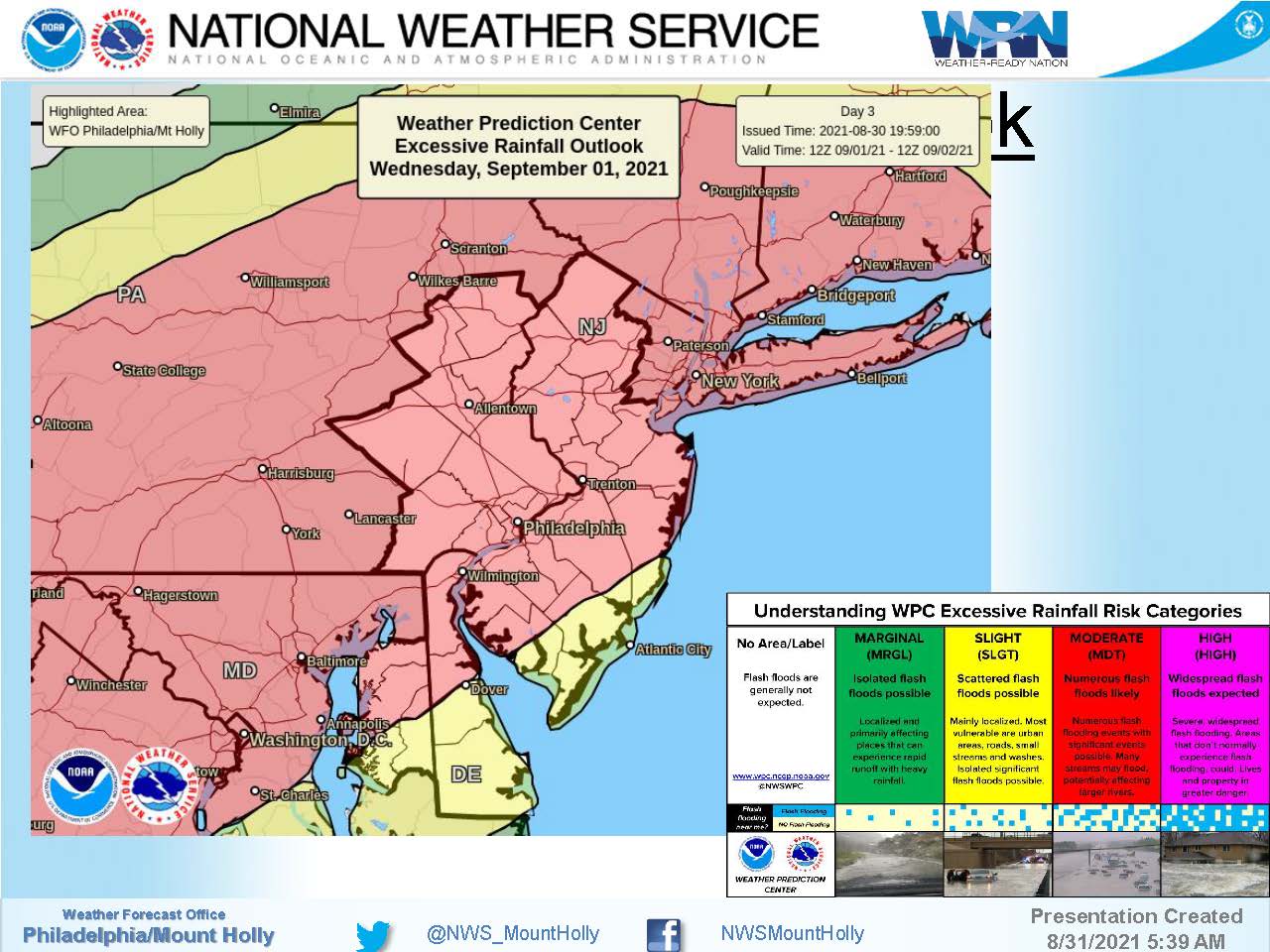
Wednesday, September 1st: Flash Flood Watch Until Thursday Morning
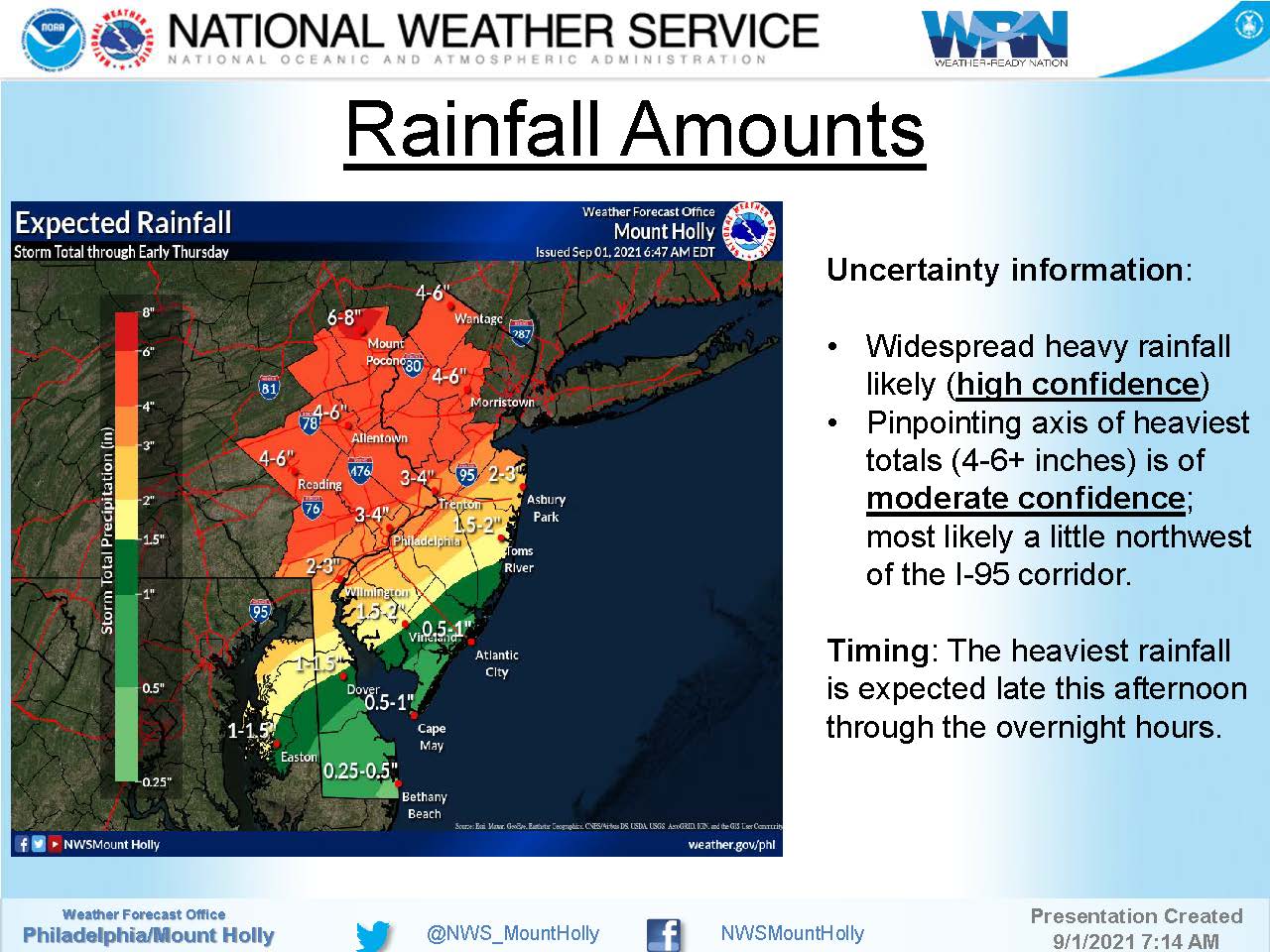
The remnants of former Hurricane Ida will spread over our region Wednesday afternoon into Thursday morning. The National Weather Service has reduced the amount of potential rainfall for Stone Harbor. However, drenching thunderstorms are still possible that may cause temporary street flooding. Never drive on a flooded street as this puts you and your vehicle in danger. The Flash Flood Watch remains in effect until Thursday morning.
Continue to monitor the forecast on traditional media outlets for updates to the forecast.
There is a risk for rip currents today along New Jersey beaches. Follow all instructions provided by the Stone Harbor Beach Patrol.
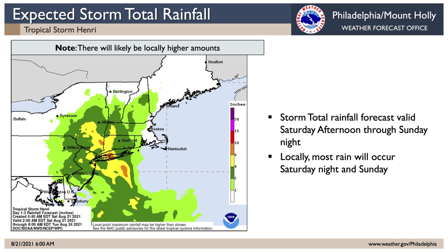
Saturday, August 21st: Henri to Become Hurricane; Rain, Minor Tidal Flooding Expected
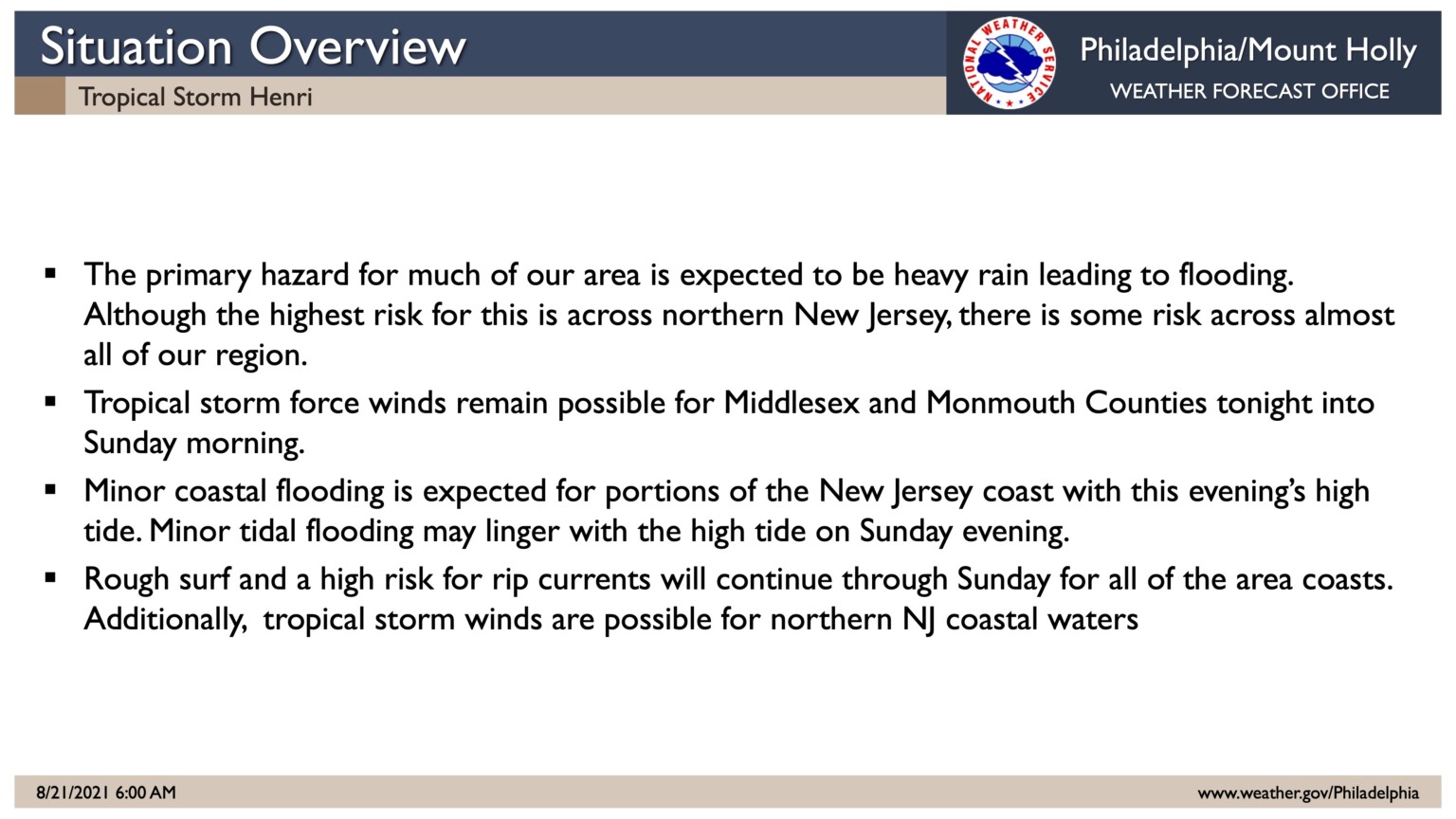
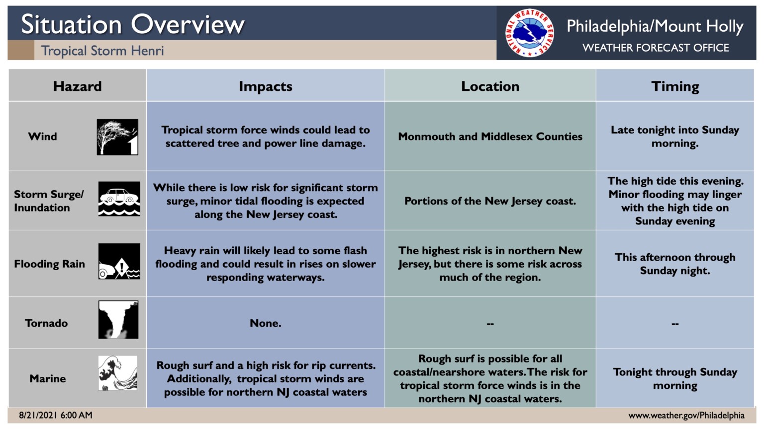
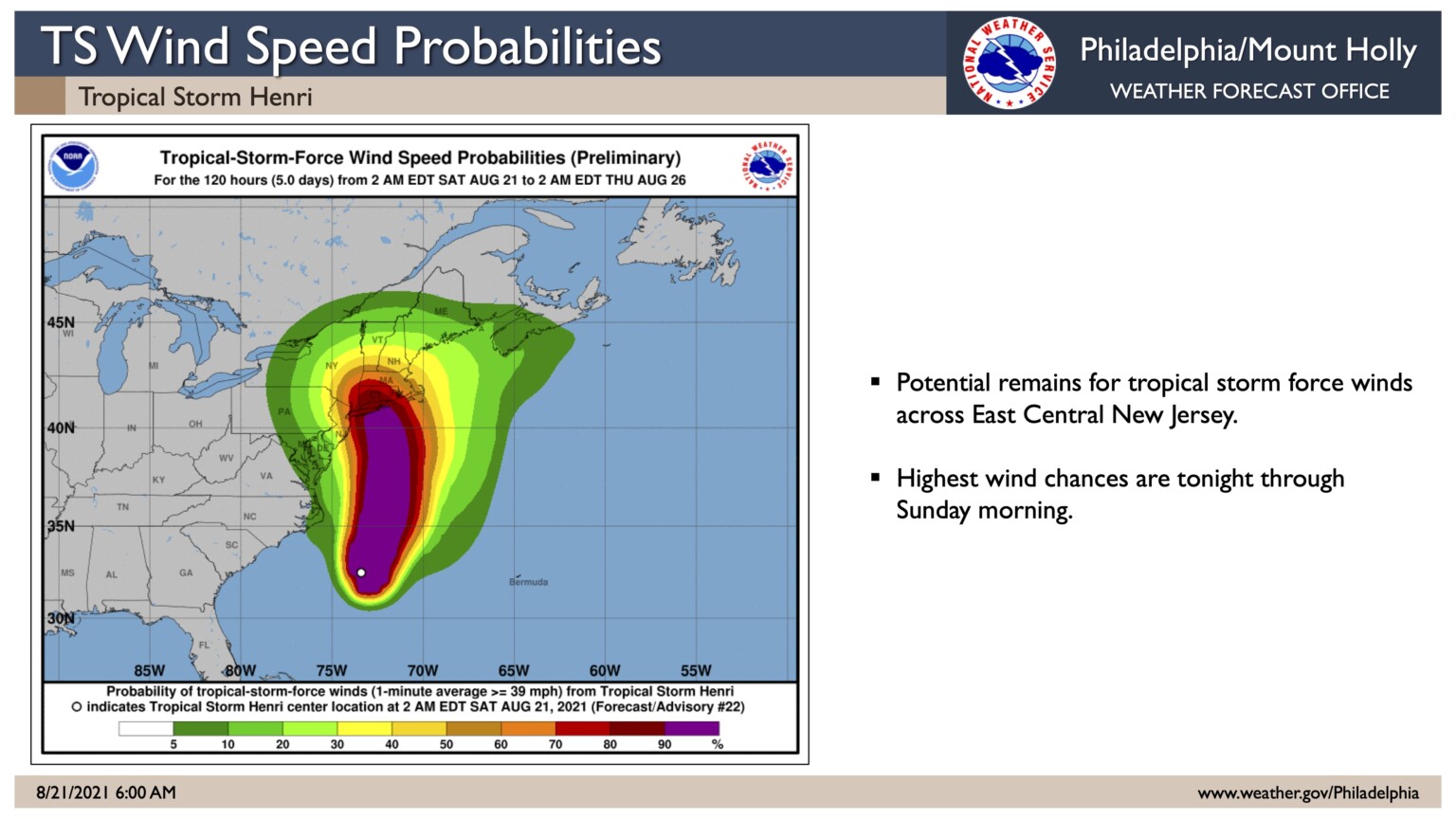
The National Weather Service has issued several alerts for our region courtesy of Tropical Storm Henri, which is expected to become an Atlantic hurricane and move offshore along the coastline of New Jersey before directly impacting the New England area.
A Flood Watch has been issued from Saturday at 2pm until Monday morning. Periods of heavy rain are possible during this storm event, especially late Saturday afternoon and into the evening which may cause temporary street flooding. Rainfall amounts of at least two inches are possible. Thunderstorms with heavy rain are possible late Saturday evening
A Coastal Flood Advisory is in effect for our area from Saturday at 7pm until early Sunday morning. Minor tidal flooding is possible at time of high tide. High tide occurs at the Townsend’s Inlet Bridge at 8:12pm on Saturday.
Please continue to monitor various advisories and alerts regarding this storm. Never drive on a flooded street as this puts you and your vehicle at risk, and can cause a wake that damages public and public property. Beach blocks in Avalon’s north end are prone to temporary flooding during heavy rainfall events. Other portions of Avalon are impacted by tidal flooding including but not limited to portions of Ocean Drive, west of the 21st and 25th street bridges, and portions of the downtown business district.
Rough surf and rip tides are expected. Follow all instructions provided by the Beach Patrol. Never enter the ocean unless you are in the presence of a lifeguard. Windy conditions are possible Saturday night. Secure any objects on your property that could be prone to gusty winds.
Thursday, July 29th, 2:38pm: Tornado Watch Issued for Cape May County Until 9pm

THE NATIONAL WEATHER SERVICE HAS ISSUED TORNADO WATCH 401 IN
EFFECT UNTIL 9 PM EDT THIS EVENING FOR THE FOLLOWING AREAS
IN DELAWARE THIS WATCH INCLUDES 3 COUNTIES
IN CENTRAL DELAWARE
KENT
IN NORTHERN DELAWARE
NEW CASTLE
IN SOUTHERN DELAWARE
SUSSEX
IN MARYLAND THIS WATCH INCLUDES 4 COUNTIES
IN NORTHEAST MARYLAND
CAROLINE KENT QUEEN ANNE’S
TALBOT
IN NEW JERSEY THIS WATCH INCLUDES 16 COUNTIES
IN CENTRAL NEW JERSEY
MERCER MONMOUTH
IN NORTHERN NEW JERSEY
HUNTERDON MIDDLESEX MORRIS
SOMERSET SUSSEX WARREN
IN SOUTHERN NEW JERSEY
ATLANTIC BURLINGTON CAMDEN
CAPE MAY CUMBERLAND GLOUCESTER
OCEAN SALEM
IN PENNSYLVANIA THIS WATCH INCLUDES 10 COUNTIES
IN EAST CENTRAL PENNSYLVANIA
BERKS LEHIGH NORTHAMPTON
IN NORTHEAST PENNSYLVANIA
CARBON MONROE
IN SOUTHEAST PENNSYLVANIA
BUCKS CHESTER DELAWARE
MONTGOMERY PHILADELPHIA
THIS INCLUDES THE CITIES OF ALLENTOWN, ATLANTIC CITY, BETHLEHEM,
BLAIRSTOWN, CAMDEN, CENTREVILLE, CHERRY HILL, CHESTERTOWN,
DENTON, DEPTFORD, DOVER, DOYLESTOWN, EAST BRUNSWICK, EASTON,
EASTON, EDISON, FLEMINGTON, FREEHOLD, GEORGETOWN, GLASSBORO,
HAMMONTON, JIM THORPE, MEDIA, MILLVILLE, MOORESTOWN, MORRISTOWN,
MOUNT HOLLY, NEW BRUNSWICK, NEWTON, NORRISTOWN,
NORTH BRUNSWICK TOWNSHIP, OCEAN CITY, PENNSVILLE, PERTH AMBOY,
PHILADELPHIA, READING, SAYREVILLE, SOMERSET, STROUDSBURG,
TOMS RIVER, TRENTON, WEST CHESTER, AND WILMINGTON.
Thursday, July 8th, 7:51am: Tropical Storm Warning Issued for Stone Harbor
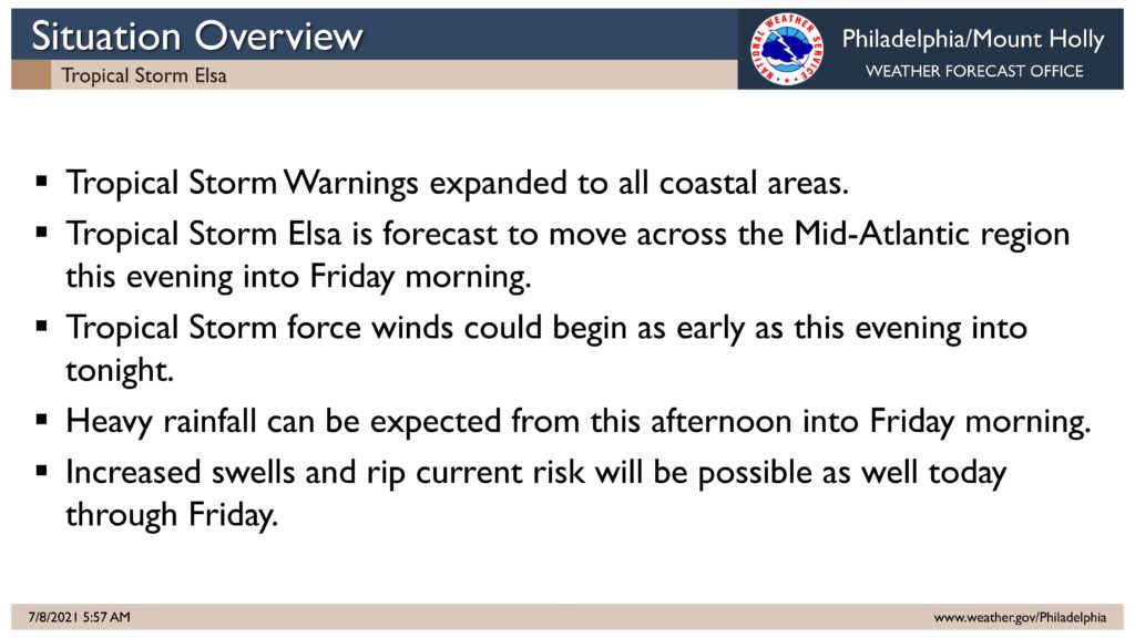
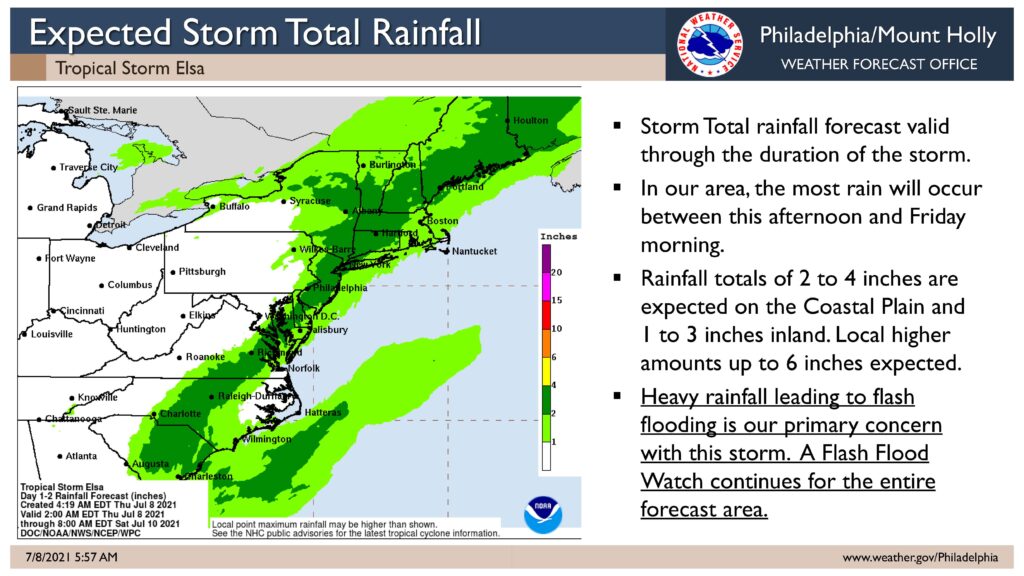
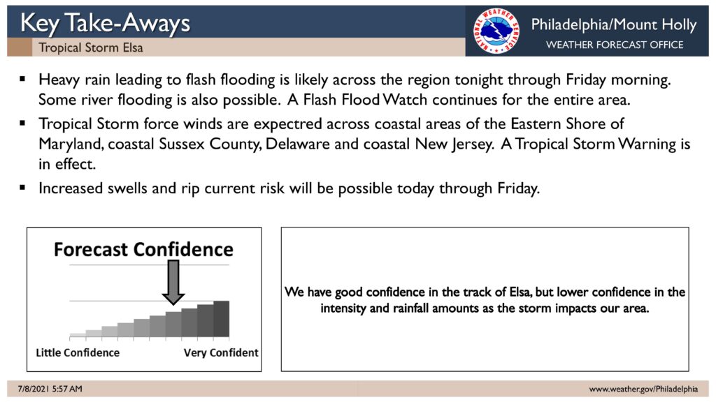
The National Weather Service has issued a Tropical Storm Warning for our region. A Flash Flood Watch remains in effect for our region from Thursday, July 8th at 5:00pm until Friday, July 9th at Noon.
Tropical Storm Elsa is expected to move up the coastline today and will likely impact our region this evening into the overnight hours. The storm may bring gusty winds and brief periods of heavy rainfall. One to two inches of rain are expected along the coast, with higher amounts possible in localized areas. The storm is expected to be out of our area by Friday at Noon.
Now is the time to secure loose objects in your yard and decks. Consider moving objects inside including patio furniture, umbrellas, lawn chairs, and trash cans. If you experience rainfall flooding on a street, do not drive through it. Rainfall flooding is a temporary condition that will drain away. Rough surf and the potential for rip currents are expected. Obey all instructions provided by the beach patrol.
We continue to remain in contact with State and County offices of emergency management during this event. Continue to monitor updates provided on traditional media outlets.
Here is the complete text of the Warning provided on Thursday, July 8th, by the National Weather Service:
Tropical Storm Warning
Elsa Local Watch/Warning Statement/Advisory Number 33
National Weather Service Mount Holly NJ AL052021
507 AM EDT Thu Jul 8 2021
NJZ024-082115-
/O.CON.KPHI.TR.W.1005.000000T0000Z-000000T0000Z/
Atlantic Coastal Cape May-
507 AM EDT Thu Jul 8 2021
…TROPICAL STORM WARNING REMAINS IN EFFECT…
* LOCATIONS AFFECTED
– Cape May
– Wildwood
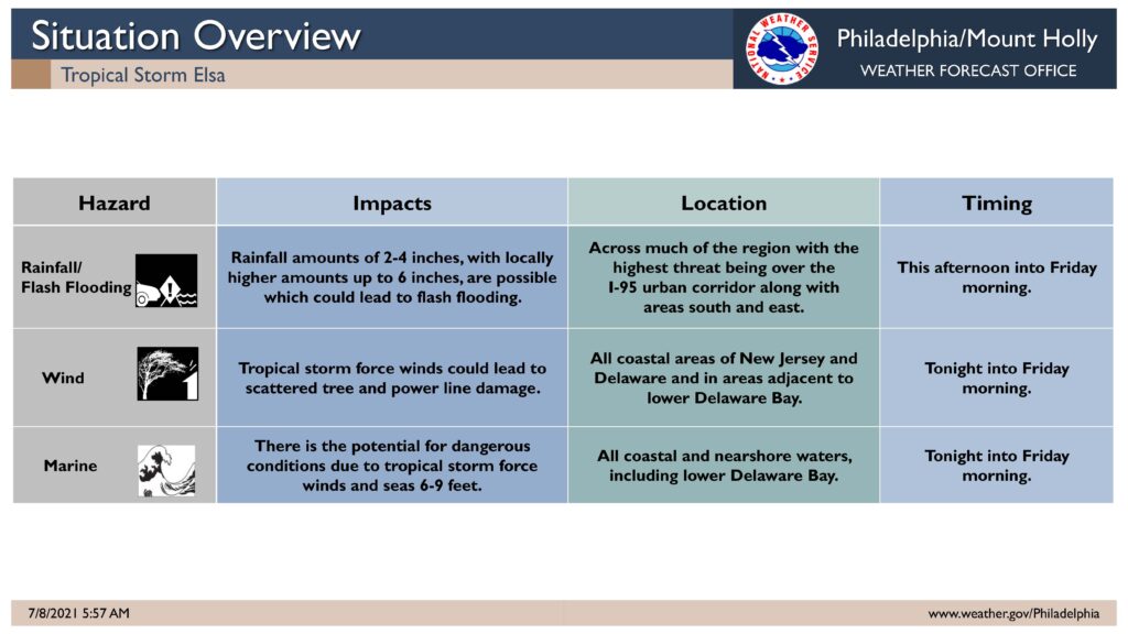
* WIND
– LATEST LOCAL FORECAST: Below tropical storm force wind
– Peak Wind Forecast: 15-25 mph with gusts to 45 mph
– THREAT TO LIFE AND PROPERTY THAT INCLUDES TYPICAL FORECAST
UNCERTAINTY IN TRACK, SIZE AND INTENSITY: Potential for wind 39
to 57 mph
– The wind threat has remained nearly steady from the
previous assessment.
– PLAN: Plan for hazardous wind of equivalent tropical storm
force.
– PREPARE: Efforts to protect property should now be
underway. Prepare for limited wind damage.
– ACT: Act now to complete preparations before the wind
becomes hazardous.
– POTENTIAL IMPACTS: Limited
– Damage to porches, awnings, carports, sheds, and unanchored
mobile homes. Unsecured lightweight objects blown about.
– Many large tree limbs broken off. A few trees snapped or
uprooted, but with greater numbers in places where trees
are shallow rooted. Some fences and roadway signs blown
over.
– A few roads impassable from debris, particularly within
urban or heavily wooded places. Hazardous driving
conditions on bridges and other elevated roadways.
– Scattered power and communications outages.
* STORM SURGE
– No storm surge inundation forecast
– THREAT TO LIFE AND PROPERTY THAT INCLUDES TYPICAL FORECAST
UNCERTAINTY IN TRACK, SIZE AND INTENSITY: Little to no storm
surge flooding
– The storm surge threat has remained nearly steady from the
previous assessment.
– PLAN: There is little to no threat of storm surge flooding.
Rough surf, coastal erosion, and life-threatening rip
currents are possible.
– PREPARE: Little to no preparations for storm surge flooding
are needed.
– ACT: Follow the instructions of local officials. Monitor
forecasts.
– REALIZED IMPACTS: Being Assessed
– Little to no additional surge impacts expected. Community
officials are now assessing the extent of actual surge
impacts accordingly.
* FLOODING RAIN
– LATEST LOCAL FORECAST: Flash Flood Watch is in effect
– Peak Rainfall Amounts: 1-3 inches, with locally higher
amounts
– THREAT TO LIFE AND PROPERTY THAT INCLUDES TYPICAL FORECAST
UNCERTAINTY IN TRACK, SIZE AND INTENSITY: Potential for
moderate flooding rain
– The flooding rain threat has remained nearly steady from
the previous assessment.
– PLAN: Emergency plans should include the potential for
moderate flooding from heavy rain. Evacuations and rescues
are possible.
– PREPARE: Consider protective actions if you are in an area
vulnerable to flooding.
– ACT: Heed any flood watches and warnings. Failure to take
action may result in serious injury or loss of life.
– POTENTIAL IMPACTS: Significant
– Moderate rainfall flooding may prompt several evacuations
and rescues.
– Rivers and tributaries may quickly become swollen with
swifter currents and overspill their banks in a few places,
especially in usually vulnerable spots. Small streams,
creeks, canals, arroyos, and ditches overflow.
– Flood waters can enter some structures or weaken
foundations. Several places may experience expanded areas
of rapid inundation at underpasses, low-lying spots, and
poor drainage areas. Some streets and parking lots take on
moving water as storm drains and retention ponds overflow.
Driving conditions become hazardous. Some road and bridge
closures.
* TORNADO
– LATEST LOCAL FORECAST:
– Situation is somewhat favorable for tornadoes
– THREAT TO LIFE AND PROPERTY THAT INCLUDES TYPICAL FORECAST
UNCERTAINTY IN TRACK, SIZE AND INTENSITY: Potential for a few
tornadoes
– The tornado threat has remained nearly steady from the
previous assessment.
– PLAN: Emergency plans should include the potential for a
few tornadoes.
– PREPARE: If your shelter is particularly vulnerable to
tornadoes, prepare to relocate to safe shelter before
hazardous weather arrives.
– ACT: If a tornado warning is issued, be ready to shelter
quickly.
– POTENTIAL IMPACTS: Limited
– The occurrence of isolated tornadoes can hinder the
execution of emergency plans during tropical events.
– A few places may experience tornado damage, along with
power and communications disruptions.
– Locations could realize roofs peeled off buildings,
chimneys toppled, mobile homes pushed off foundations or
overturned, large tree tops and branches snapped off,
shallow-rooted trees knocked over, moving vehicles blown
off roads, and small boats pulled from moorings.
Wednesday, July 7th, 12:13pm: Tropical Storm Watch Issued for Stone Harbor
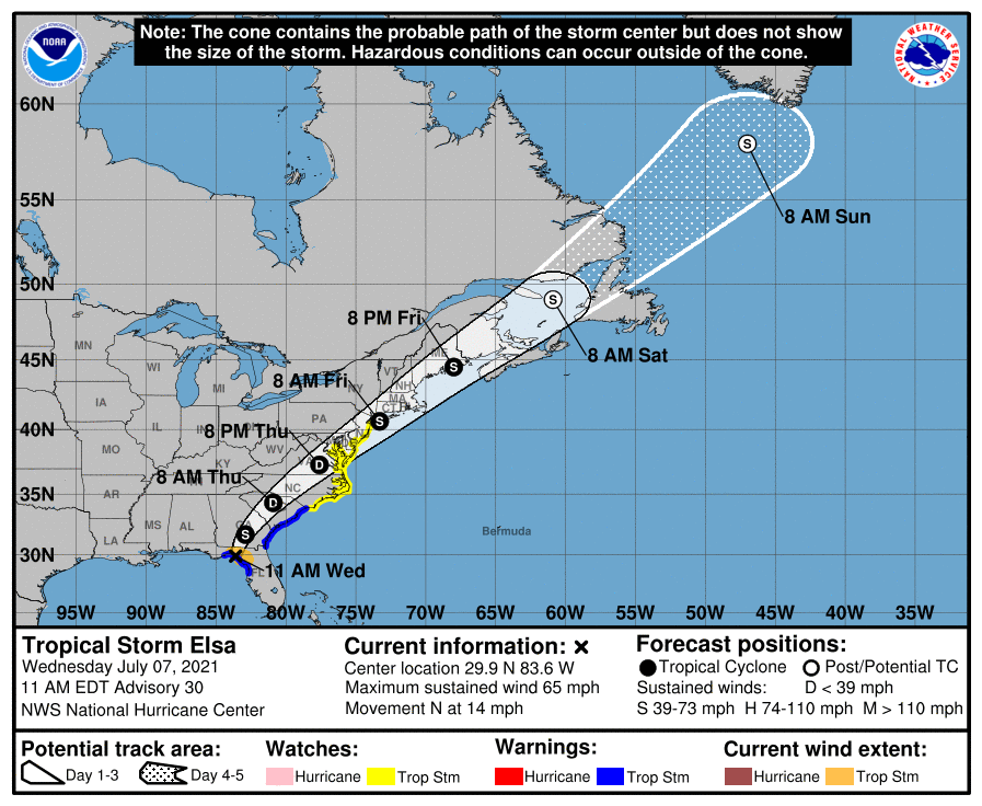
The National Weather Service has issued a Tropical Storm Watch for Stone Harbor and the southern New Jersey Shore region. The Watch means that tropical storm force winds are possible in our area over the next 48 hours. The Watch was issued late Wednesday morning, July 7th.
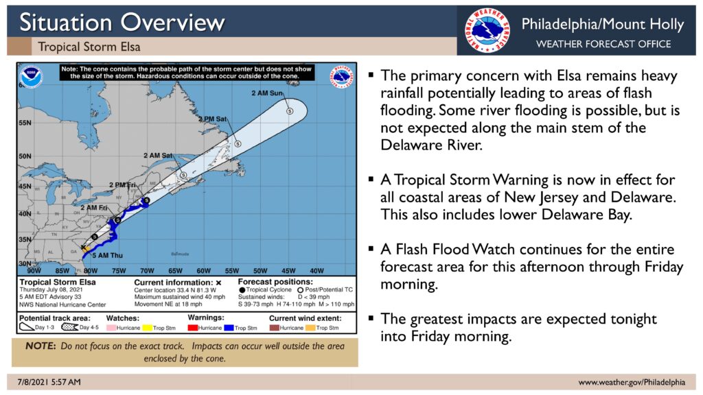
Tropical Storm Elsa is expected to be downgraded to a tropical depression when it moves over land. The current forecast path has the storm moving past our region late Thursday night into Friday morning. As of the current forecast, Elsa is expected to regain strength to a tropical storm late this week.
The latest advisory is calling for 20-30mph winds with gusts to 40mph. Rain is possible Thursday night into Friday. Further impacts from this storm event will be forthcoming. Please continue to follow all instructions provided by the Stone Harbor Beach Patrol as rough surf and rip currents are possible, and if necessary, from the Stone Harbor Office of Emergency Management.
The National Weather Service will have further advisories later today. Continue to monitor this site and traditional media outlets for updated information.
Tropical Storm Elsa Local Statement Advisory Number 30
National Weather Service Mount Holly NJ AL052021
1200 PM EDT Wed Jul 7 2021
This product covers New Jersey, Delaware, southeastern Pennsylvania
and the Eastern Shore of Maryland
**Elsa is Expected to Impact Portions of southern Delaware and eastern
New Jersey late Thursday into Friday morning**
NEW INFORMATION
—————
* CHANGES TO WATCHES AND WARNINGS:
– A Tropical Storm Watch has been issued for Atlantic, Atlantic
Coastal Cape May, Cape May, Caroline, Coastal Atlantic, Coastal
Ocean, Delaware Beaches, Eastern Monmouth, Inland Sussex,
Ocean, Queen Annes, Southeastern Burlington, Talbot, and
Western Monmouth
* CURRENT WATCHES AND WARNINGS:
– A Tropical Storm Watch is in effect for Atlantic, Atlantic
Coastal Cape May, Cape May, Caroline, Coastal Atlantic, Coastal
Ocean, Delaware Beaches, Eastern Monmouth, Inland Sussex,
Ocean, Queen Annes, Southeastern Burlington, Talbot, and
Western Monmouth
* STORM INFORMATION:
– About 830 miles southwest of Atlantic City NJ or about 780
miles southwest of Dover DE
– 29.9N 83.6W
– Storm Intensity 65 mph
– Movement North or 360 degrees at 14 mph
SITUATION OVERVIEW
—————–
Tropical Storm Elsa will make landfall along the west coast of Florida
later this morning and then track northeast through Georgia into the
Carolinas later tonight into Thursday morning. Elsa is then forecast to
move across southern Delaware and eastern New Jersey late Thursday
night into Friday morning. Elsa is then forecast to continue to
accelerate and move northeast, away from New Jersey, late Friday
morning.
The main threats with this system are heavy rainfall resulting in
flash flooding as well as some river flooding, as well as tropical
storm force winds, especially near the coast. In addition, dangerous
marine conditions will occur, along with the potential for dangerous
rip currents.
One to three inches of rainfall are forecast Thursday afternoon into
Friday morning. Heavy rainfall will result in a threat of localized
flash flooding. Dangerous marine conditions are also expected to
develop along the Delaware Bay waters south of Slaughter Beach and
along the Atlantic Coastal Waters for all of Delaware and up towards
Sandy Hook, NJ. Tropical Storm force winds will be most likely across
the waters with seas building to 6 to 9 feet. Dangerous rip currents
will likely occur along the ocean beaches of Delaware and New Jersey.
