Thurs, Jan. 21st, 6:30pm: Coastal Flood Watch/High Wind Watch In Effect, Flooding Likely

Flooding Potential Thurs 5pm

The National Weather Service has issued a Coastal Flood Watch and a High Wind Watch for the Borough of Stone Harbor. The Flood Watch is in effect from late Friday night, January 22nd through Sunday at 12 Noon on January 24th. The High Wind Watch is in effect for the entire day on Saturday, January 23rd. Today, Stone Harbor participated in a conference with the Cape May County Office of Emergency Management which is under the leadership of its director, Martin Pagliughi.

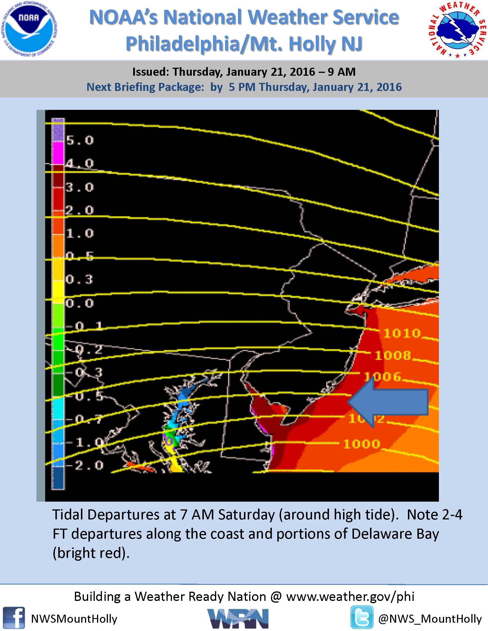
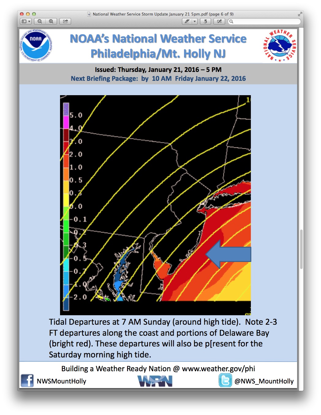
A major coastal storm will bring snow, rain, strong winds, and coastal flooding to the entire State of New Jersey this weekend. Stone Harbor expects the storm to begin as snow Friday evening, change over to a snow/rain mix and eventually all rain on Saturday, before potentially switching back to snow on Saturday night into Sunday morning. Avalon also expects very strong winds during this storm event, and widespread moderate and possibly major tidal flooding during three high tide cycles, two on Saturday and one on Sunday.

High tide will occur at the Townsend’s Inlet Bridge between Avalon and Sea Isle City on Saturday at 7:17am and again at 7:43pm, and again on Sunday at 8:00am and again at 8:27pm. The forecast predicts moderate coastal flooding throughout flood-prone areas in our community.

Residents who live on a street that typically floods during coastal storms should move their vehicles to higher ground.  Street flooding is expected during both high tides on Saturday, and the morning high tide on Sunday. Never attempt to drive on any street covered by water; this puts you, your vehicle, and emergency responders in harm’s way. Driving on a flooded street also creates an unnecessary wake that could cause property damage to homes and businesses. Water on a street is always deeper than you believe it is.

The High Wind Watch means that Stone Harbor will likely experience steady winds out of the northeast at 35-45mph, with gusts at 60mph or greater. This can result in downed power lines, downed trees, and other hazards in the roadway. Please take this opportunity to bring inside (or secure) objects prone to strong winds including patio furniture and trash cans. Contractors are asked to secure their job sites to prevent debris from being scattered through neighborhoods.

Power out­ages are pos­si­ble dur­ing this storm event due to the strong winds. If you expe­ri­ence a power out­age, do not assume some­one else has called in the out­age. Call the Atlantic City Elec­tric out­age num­ber at 1–800-833-7476. You may also visit Atlantic City Elec­tric web­site to the view the cur­rent out­age map for their ser­vice area. If you have any emer­gency, please dial 911.

Updates are available on this website throughout this storm and on Channel 97 for Comcast customers.

The Wetlands Institute located on Stone Harbor Boulevard has several video cameras where you can watch the effects of the weekend snowstorm live from your computer or phone. The Institute will be closed to the public on both Saturday and Sunday due to the storm event. The link for the webcams is: opens in a new windowWetlands Institute Live Cams

Here is the latest forecast issued by the National Weather Service on Thursday, January 21st, at 5:00pm:
Tonight: Mostly clear, with a low around 23. Northwest wind 10 to 13 mph.
Friday: Increasing clouds, with a high near 35. North wind 8 to 16 mph.
Friday Night: Snow before 1am, then rain and sleet between 1am and 4am, then rain after 4am. Low around 30. Windy, with a northeast wind 17 to 22 mph increasing to 31 to 36 mph after midnight. Winds could gust as high as 55 mph. Chance of precipitation is 100%. New snow and sleet accumulation of less than one inch possible.
Saturday: Rain. High near 41. Very windy, with a northeast wind 39 to 43 mph, with gusts as high as 60 mph. Chance of precipitation is 100%. New precipitation amounts between three quarters and one inch possible.
Saturday Night: Snow. Low around 31. Very windy, with a north wind 38 to 43 mph decreasing to 30 to 35 mph after midnight. Winds could gust as high as 55 mph. Chance of precipitation is 100%. New snow accumulation of 1 to 3 inches possible.
Sunday: A chance of snow, mainly before 11am. Partly sunny, with a high near 38. Windy. Chance of precipitation is 40%.

Thurs, Jan. 21st, 6:30pm: Coastal Flood Watch/High Wind Watch In Effect, Flooding Likely2016-01-21T23:26:07-05:00

Thurs, Jan. 21st, 9:20am: Latest Weather Briefing From National Weather Service

National Weather Service Briefing Thurs January 21st PHOTOS_Page_5

The Cape May County Office of Emergency Management has provided the Borough of Stone Harbor with the latest weather briefing package via the National Weather Service.  Attached is the package that details coastal flooding and strong winds for our community and coastal areas.  National Weather Service Briefing Thurs January 21st 900am

Thurs, Jan. 21st, 9:20am: Latest Weather Briefing From National Weather Service2016-01-21T14:21:25-05:00

Thurs, Jan. 21st, 8:42am: Coastal Flood Watch Continues, Flooding/Strong Winds Associated With Weekend Storm

The National Weather Service has continued the Coastal Flood Watch for the Borough of Stone Harbor and surrounding communities.  The Watch is in effect from Saturday, January 23rd at 4:00am until Sunday, January 24th at 12 Noon.  This Watch is associated with a major winter storm that will have significant impacts on the eastern seaboard of the United States, including coastal areas of New Jersey.  The Watch includes the potential for widespread moderate coastal flooding and the potential for localized areas of major coastal flooding.  There will be very strong winds associated with this storm with sustained winds at 45mph with gusts that can possibly exceed 55mph.  There are even stronger wind gusts possible during this storm event which could result in downed trees and loss of power and other utilities.

The Stone Harbor Office of Emergency Management will participate in a meeting with the Cape May County Office of Emergency Management this afternoon.  We expect further updates and advisories throughout the day, into this evening, and during the storm event.  The inclement weather will begin Friday evening and last through Sunday morning.

It is very important to be aware of the upcoming high tides, especially on Saturday and Sunday as we expect coastal flooding in Stone Harbor.  High tide on Saturday will occur at 7:17am, and again at 7:43pm.  High tide occurs on Sunday at 8:00am, and again at 8:27pm.  Please begin to take necessary precautions.  Objects like patio furniture and trash cans that are subject to high winds should be secured or brought inside.  If you live on a street that typically receives flooding during coastal storms, make plans to move your vehicle to another location.  During the storm event, never attempt to drive on any flooded street or through any flooded intersection.  This puts you, your vehicle, and emergency personnel in harm’s way.  Driving on a flooded street can also create a small wake that can cause property damage to businesses and residential properties.  The Townsend’s Inlet Bridge remains closed through this storm event for repairs to the bridge and the roadway.

Power outages are possible during this storm event due to the strong winds.  If you experience a power outage, do not assume someone else has called in the outage.  Call the Atlantic City Electric outage number at 1-800-833-7476.  You may also visit opens in a new window Atlantic City Electric website to the view the current outage map for their service area.  If you have any emergency, please dial 911.

We expect further updates to the weather forecast from the National Weather Service throughout the day, and during this storm event.  The current forecast is posted below:

Today
Sunny, with a high near 36. Northwest wind 11 to 16 mph.
Tonight
Mostly clear, with a low around 25. North wind 8 to 15 mph.
Friday
Increasing clouds, with a high near 33. North wind 8 to 13 mph.
Friday Night
Snow between 8pm and 2am, then rain and sleet after 2am. Low around 31. Windy, with a northeast wind 15 to 20 mph increasing to 29 to 34 mph after midnight. Winds could gust as high as 50 mph. Chance of precipitation is 100%. New snow and sleet accumulation of around an inch possible.
Saturday
Rain. High near 41. Very windy, with a northeast wind 38 to 43 mph, with gusts as high as 55 mph. Chance of precipitation is 100%. New precipitation amounts between three quarters and one inch possible.
Saturday Night
Rain before 8pm, then snow. Low around 31. Very windy. Chance of precipitation is 100%. New precipitation amounts between a quarter and half of an inch possible.
Sunday
Snow likely, mainly before 8am. Mostly cloudy, with a high near 37. Windy. Chance of precipitation is 70%.
Thurs, Jan. 21st, 8:42am: Coastal Flood Watch Continues, Flooding/Strong Winds Associated With Weekend Storm2016-01-21T13:43:01-05:00

Wed, Jan. 20th: Atlantic City Electric Offers Contact Information/Tips for Approaching Storm

MAYS LANDING, N.J. — Atlantic City Electric is closely monitoring the weather forecast that calls for snow, rain and strong winds which could potentially affect the company’s service territory Friday evening and through the weekend. The National Weather Service has issued a hazardous weather outlook for the region.

High winds and heavy, wet snow can weigh down tree limbs and bring them into contact with power lines causing power outages. Wet snow can also adversely affect saturated soil and allow trees already weakened by previous storms to fall onto power lines and equipment, causing power outages. Outages can also occur due to drivers skidding into utility poles along icy and snow-covered roads.

In addition to internal crews available 24 hours a day throughout the weekend, Atlantic City Electric has overhead line contractors and tree crews available to assist in any restoration effort.

Should outages occur, Atlantic City Electric will work around the clock to restore service, however, customers should be prepared for the possibility of service interruptions which could last several days depending on the damage to the electric system. For the safety of the overhead line personnel, if sustained winds reach 35 mph, work that requires raising a bucket/arm boom will be interrupted until it is safe for the crews to continue.

Atlantic City Electric coordinates with state, county and local emergency management officials during severe storm events. Our call Centers are staffed and prepared for this event.

Safety is our No. 1 priority. We urge our customers to stay clear of working crews and any wires hanging loose from poles or lying on the ground. Customers should always assume that downed wires are energized and avoid them. Customers are asked to immediately report a downed wire by calling 1-800-833-7476.

Preparedness tips for Atlantic City Electric customers:

  • Assemble an emergency storm kit. Include a battery-powered radio or television, flashlight, a first-aid kit, battery-powered or windup clock, extra batteries, special needs items, an insulated cooler and a list of important and emergency phone numbers.
  • Keep at least a three-day supply of nonperishable foods and bottled water and have a hand-operated can opener available.
  • Have adequate prescription medicines or infant supplies on hand.
  • Make sure you have a telephone with a cord or cell phone to use as a backup. Cordless telephones require electricity to operate and won’t work if there is an outage.
  • Identify a safe alternate location in case of an extended outage.
  • Tune to local news broadcasts for the latest weather and emergency information.
  • Follow the advice of local emergency management officials.


General Safety Tips:

  • Protect electronic equipment. Unplug sensitive electronics or plug computers and other sensitive equipment into surge suppressors and consider an uninterruptible power supply for temporary battery backup power.
  • If a portable generator is needed, follow the manufacturer’s instructions and use only when necessary. Never run a generator indoors or inside an attached garage. Be sure to place the generator outside where deadly exhaust fumes will not enter into the home.
  • Do not connect a generator directly to the home’s wiring. If a generator is plugged into the electrical circuits of a home, power can back-feed into Atlantic City Electric’s lines, which can injure or kill utility workers fixing downed power lines. It also can cause downed lines to re-energize.
  • Turn off power to flood-prone basement appliances if it is safe to do so. However, if using an electrically operated sump pump, the customer should not turn off the power.

We also ask customers to let us know if they lose their power. They can report outages by calling 1-800-833-7476, visiting www.atlanticcityelectric.com or through our mobile app, available for download at www.atlanticcityelectric.com/mobileapp. It’s important that customers report their outages and request a call back to verify their power has been restored.

Wed, Jan. 20th: Atlantic City Electric Offers Contact Information/Tips for Approaching Storm2016-01-21T00:20:20-05:00

Wed, Jan. 20th, 5:40pm: Coastal Flood Watch Posted, Winter Weather On Its Way

Winter Storm Flood Coast Wednesday pm

The National Weather Service has issued both a Coastal Flood Watch for the Borough of Stone Harbor and other coastal communities in advance of a winter storm that will impact our region especially on Friday and Saturday. There is the potential for snow, rain, strong winds, and at least moderate coastal flooding from this storm event. This has been a difficult forecast for the National Weather Service and we expect further updates with more specific information over the next 48 hours as the storm approaches the Mid-Atlantic region.

There is the potential for some light snow this evening over our community during the overnight hours into early Thursday morning. This is not associated with the larger winter storm that will impact our area on Friday and Saturday, January 22nd-23rd. Snow possibly mixing with rain is expected over our region late Friday afternoon with the precipitation becoming all rain during the overnight hours Friday into Saturday. Winds will be gusty during the overnight hours and approach 50mph. Saturday’s forecast brings plenty of rain to our community along with very windy conditions, with gusts approaching 60mph. The storm is expected to end as a mix of rain and snow before Midnight Saturday. Some light snow and rain is possible on Sunday morning before the storm moves away from our region.

Areas towards Philadelphia will be experiencing a significant snowfall event. The Wednesday evening forecast does not call for significant snowfall for our immediate area; our biggest concerns remain coastal flooding, strong winds, rough surf/beach erosion, and the potential for power outages. Please remember: This forecast has the potential to change over the next 48 hours; we invite you to follow www.stoneharboremergency.com for updated information during this storm event.

The Coastal Flood Watch for our region calls for widespread moderate coastal flooding throughout the Jersey Shore, with the potential for major coastal flooding in some areas. The National Weather Service believes this flooding event will likely cover three high tides, two on Saturday and the morning high tide event on Sunday. Wave heights on the ocean could build to 20 feet on Saturday on the ocean front. Streets that typically flood during coastal flood events are expected to experience high water during these high tides.

High tide at the Townsend’s Inlet Bridge between Avalon and Sea Isle City will occur Saturday at 7:17am, and again at 743pm. High tide on Sunday occurs at 8:00am, and again at 8:27pm. Please note the bridge is closed for the next few weeks as final repairs are being made on the bridge and on the roadway approaching the bridge.

If you live on a street that typically floods during coastal flooding events, please consider moving your vehicles to higher ground especially during the Saturday high tide events. Please plan to secure outdoor objects that are prone to high winds, including deck furniture and trash cans. Never attempt to drive through any high water on a street or intersection. If you have any emergency, dial 911. The Stone Harbor Department of Emergency Management is in constant communication with the Cape May County Office of Emergency Management and our weather partners to bring you the latest information.

Power outages are possible during this winter storm. You can view the Atlantic City Electric power outage map and you can report a power outage as well on opens in a new windowwww.atlanticcityelectric.com.

Here is the advisory provided to emergency management partners throughout the Philadelphia region by the National Weather Service:  National Weather Service Storm Discussion Wednesday evening January 20th

Wed, Jan. 20th, 5:40pm: Coastal Flood Watch Posted, Winter Weather On Its Way2016-01-20T22:41:37-05:00

Wed, January 20th: Increased Threat of Coastal Flooding During Weekend Storm

The National Weather Service continues to track a major winter storm that is expected to impact Stone Harbor and the eastern seaboard of the United States this Friday and Saturday, January 22nd-23rd. The Service is now confident that there will be a greater flooding risk to barrier island communities along the New Jersey shoreline as a result of this coastal storm.

A storm is moving in our direction and is expected to bring some snow, rain, strong winds, and moderate to potentially major coastal flooding in our region. As of Wednesday morning at 6:00am there were no official advisories, watches, or warnings, but they are expected in the next 24 hours. The heaviest snow currently is forecasted to be away from the coastline, although some snow is expected in our community. A full moon is expected to complicate the flooding along the New Jersey shore. A track closer to the shore would bring more rain to our region, and a track to the south would lessen the overall impacts. Please continue to monitor this website and traditional media outlets for the updated information over the next few days.

The strongest winds are currently expected to be during the morning hours on Saturday.

Here is the latest briefing from the National Weather Service. Please remember, this forecast can change over the next 48 hours:  National Weather Service Update Weekend Coastal Storm

Wed, January 20th: Increased Threat of Coastal Flooding During Weekend Storm2016-01-20T11:37:27-05:00

Tuesday, January 19th: Winter Storm Coming, Potential for Coastal Flooding for Coastal Communities

Winter Storm Graphic January 19 2016_Page_1

The National Weather Service has issued its first formal advisory for a winter storm that will impact the East Coast during the weekend.  The storm is expected to bring moderate coastal flooding to our region, along with the possibility of some snow and rain, strong gusty winds and beach erosion.  Snowfall totals are not predicted at this time but the early estimate is most of the heavy snow will stay away from the beaches in the southern New Jersey shoreline, including Stone Harbor.  However, flooding will be a concern during this event which will last at least Friday and Saturday.  Please keep checking our emergency management website for updates on this storm event.

There will be a full moon during this storm event as well.  For reference purposes, high tide at the Townsend’s Inlet Bridge between Avalon and Sea Isle City is as follows (please note: The bridge is currently closed for repairs):   Friday:  6:31am, 6:57pm      Saturday:  7:17am, 7:43pm

Here is the storm alert issued on Tuesday, January 19th, for the approaching winter storm:  National Weather Service Briefing Tuesday, January 19th Weekend Coastal Storm

Tuesday, January 19th: Winter Storm Coming, Potential for Coastal Flooding for Coastal Communities2016-01-19T15:43:56-05:00

Sunday, January 17th: Winter Weather Advisory Posted for Stone Harbor

The National Weather Service has posted a Winter Weather Advisory for Stone Harbor for Sunday, January 17th, 2016. Between one to three inches of snow is possible during the day on Sunday. Exercise caution while driving. Here is the text of the Advisory issued by the National Weather Service:

… Winter Weather Advisory in effect until 7 PM EST this
evening…

The National Weather Service in Mount Holly has issued a Winter
Weather Advisory for snow… which is in effect until 7 PM EST
this evening.

* Locations… southern Eastern Shore of Maryland, central and
southern Delaware, and southern New Jersey.

* Hazard types… snow.

* Snow accumulations… accumulations of 1 to 3 inches expected.

* Temperatures… dropping to near freezing.

* Visibilities… dropping down to around 1 mile with lower
visibilities possible.

* Impacts… roadways will become wet as snow falls with
accumulations largely occurring on non-paved surfaces. Wet
roadways will become slippery and may freeze tonight as
temperatures fall below the freezing mark.

Precautionary/preparedness actions…

A Winter Weather Advisory for snow means that periods of snow
will cause primarily travel difficulties. Be prepared for snow
covered roads and limited visibilities… and use caution while
driving.

Sunday, January 17th: Winter Weather Advisory Posted for Stone Harbor2016-01-17T19:02:54-05:00
Go to Top