Thurs, Sept. 1st, 5:44pm: Tropical Storm Watch Posted for Stone Harbor

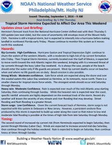
The National Weather Service has posted a Tropical Storm Watch for Stone Harbor and all of Cape May County. This Tropical Storm Watch is now in effect for a portion of Labor Day weekend with the strongest effects of this storm over our area on Saturday and Sunday. Hurricane Hermine is expected to bring strong winds, some heavy rain, coastal flooding, rough surf, beach erosion, and strong rip currents along the shore for the holiday weekend, especially on Saturday and Sunday. Please continue to monitor this storm for updates as they become available, especially over the next 24 hours.
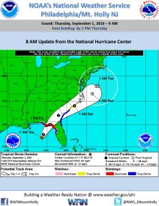
Hermine was upgraded to a hurricane and at this hour continues to be a major threat to northern Florida. The storm will move up the eastern seaboard and its current path will put the storm fairly close to the New Jersey coastline. The National Weather Service has a high confidence for rip currents and tidal flooding, and moderate confidence for heavy rain and strong winds.
Storms like these pose threats to barrier islands including the Borough of Stone Harbor. We may experience flooding from periods of heavy rain or coastal flooding due to high tides. Never attempt to drive on any flooded street or through any flooded intersection as this puts you and your vehicle at risk; driving on a flooded street also causes an unnecessary wake that can damage property other than your own. Never drive over any downed utility wire. Rain could be heavy at times especially during the daytime hours on Sunday
Heed all warnings provided by the Stone Harbor Beach Patrol. During this storm event, do not venture into the ocean. Rip currents and pounding surf are expected to be common during this storm event. Friday should be a sunny day; do not enter the ocean unless you are in a presence of an on-duty lifeguard.
If you own property in the Borough, prepare for the possibility of strong gusty winds of 30-35mph or higher. Secure all outdoor objects including trash cans, umbrellas, and patio furniture. Winds will be strongest from around midday on Saturday through the remainder of the holiday weekend.
Minor tidal flooding is possible with the Saturday evening high tide and could worsen during the Sunday high tide events. If you live in an area of Stone Harbor that typically floods, please consider moving your vehicle out of that area to higher ground.
High tide in Townsend’s Inlet between Avalon and Sea Isle City will occur on Saturday, September 3rd at 10:36am, and again at 10:48pm. High tide on Sunday will occur at 11:14am, and again at 11:25pm.
Here is the official briefing on the storm from the National Weather Service, courtesy of the Stone Harbor Office of Emergency Management:
Hermine_Briefing_02_Sep 1 2016 500 PM
Here is the text of a briefing provided by the National Weather Service:
Hurricane Local Statement
TROPICAL STORM HERMINE LOCAL STATEMENT SPECIAL ADVISORY NUMBER 17
DEZ001>004-MDZ008-012-015-019-020-NJZ001-007>010-012>027-PAZ054-055-060>062-070-071-101>106-020500-
TROPICAL STORM HERMINE LOCAL STATEMENT SPECIAL ADVISORY NUMBER 17
NATIONAL WEATHER SERVICE MOUNT HOLLY NJ AL092016
449 PM EDT THU SEP 1 2016
THIS PRODUCT COVERS NEW JERSEY…DELAWARE…SOUTHEASTERN PENNSYLVANIA AND NORTHEAST MARYLAND.
**HERMINE TO AFFECT THE REGION THIS WEEKEND**
NEW INFORMATION
—————
* CHANGES TO WATCHES AND WARNINGS:
– A TROPICAL STORM WATCH HAS BEEN ISSUED FOR INLAND
SUSSEX…DELAWARE BEACHES…WESTERN MONMOUTH…EASTERN
MONMOUTH…OCEAN…ATLANTIC…CAPE MAY…ATLANTIC COASTAL CAPE
MAY…COASTAL ATLANTIC…COASTAL OCEAN AND SOUTHEASTERN
BURLINGTON
* CURRENT WATCHES AND WARNINGS:
– A TROPICAL STORM WATCH IS IN EFFECT FOR INLAND
SUSSEX…DELAWARE BEACHES…WESTERN MONMOUTH…EASTERN
MONMOUTH…OCEAN…ATLANTIC…CAPE MAY…ATLANTIC COASTAL CAPE
MAY…COASTAL ATLANTIC…COASTAL OCEAN AND SOUTHEASTERN
BURLINGTON
* STORM INFORMATION:
– ABOUT 1020 MILES SOUTHWEST OF ATLANTIC CITY NJ OR ABOUT 970
MILES SOUTHWEST OF DOVER DE
– 27.8N 85.6W
– STORM INTENSITY 70 MPH
– MOVEMENT NORTH-NORTHEAST OR 30 DEGREES AT 14 MPH
SITUATION OVERVIEW
——————
HERMINE WILL BE AFFECTING COASTAL AREAS OF DELAWARE AND NEW JERSEY
THROUGH THE HOLIDAY WEEKEND. HURRICANE HERMINE IS FORECAST TO MAKE
LANDFALL TONIGHT IN NORTHERN FLORIDA. THE STORM IS THEN EXPECTED
TO MOVE NORTHEASTWARD, MOVING INTO THE ATLANTIC BY SATURDAY AND
STAYING OFF THE THE COAST THROUGH THE WEEKEND.
POTENTIAL IMPACTS
—————–
* FLOODING RAIN: PREPARE FOR LOCALLY HAZARDOUS RAINFALL FLOODING
HAVING POSSIBLE LIMITED IMPACTS ACROSS COASTAL LOCATIONS AND THE
COASTAL PLAINS. POTENTIAL IMPACTS INCLUDE: – LOCALIZED RAINFALL
FLOODING MAY PROMPT A FEW EVACUATIONS. – RIVERS AND TRIBUTARIES
MAY QUICKLY RISE WITH SWIFTER CURRENTS. SMALL STREAMS, CREEKS,
CANALS, AND DITCHES MAY BECOME SWOLLEN AND OVERFLOW IN SPOTS. –
FLOOD WATERS CAN ENTER A FEW STRUCTURES, ESPECIALLY IN
VULNERABLE SPOTS. RAPID PONDING OF WATER MAY OCCUR AT
UNDERPASSES, LOW-LYING SPOTS, AND POOR DRAINAGE AREAS. SEVERAL
STORM DRAINS AND RETENTION PONDS BECOME NEAR-FULL AND BEGIN TO
OVERFLOW. SOME BRIEF ROAD AND BRIDGE CLOSURES ARE POSSIBLE.
ELSEWHERE ACROSS NEW JERSEY…DELAWARE…SOUTHEASTERN PENNSYLVANIA
AND NORTHEAST MARYLAND., LITTLE TO NO IMPACT IS ANTICIPATED.
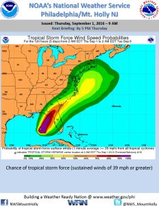
* WIND:
PREPARE FOR HAZARDOUS WIND HAVING POSSIBLE LIMITED IMPACTS ACROSS NEW
JERSEY…DELAWARE…SOUTHEASTERN PENNSYLVANIA AND NORTHEAST
MARYLAND.. POTENTIAL IMPACTS INCLUDE:
– DAMAGE TO PORCHES, AWNINGS, CARPORTS, SHEDS, AND UNANCHORED
MOBILE HOMES IS POSSIBLE. UNSECURED LIGHTWEIGHT OBJECTS COULD
BE BLOWN AROUND.
– MANY LARGE TREE LIMBS MAY BE BROKEN OFF. A FEW TREES COULD BE
SNAPPED OR UPROOTED. SOME FENCES AND ROADWAY SIGNS MAY BE BLOWN
OVER.
– A FEW ROADS COULD BE IMPASSABLE FROM DEBRIS. HAZARDOUS DRIVING
CONDITIONS ARE POSSIBLE ON BRIDGES AND OTHER ELEVATED ROADWAYS.
– SCATTERED POWER AND COMMUNICATIONS OUTAGES ARE POSSIBLE.
* SURGE: LITTLE TO NO IMPACTS ARE ANTICIPATED AT THIS TIME ACROSS
NEW JERSEY…DELAWARE…SOUTHEASTERN PENNSYLVANIA AND NORTHEAST
MARYLAND. HOWEVER…TIDAL FLOODING IS POSSIBLE.
PRECAUTIONARY/PREPAREDNESS ACTIONS
———————————-
* EVACUATIONS:IF YOU ARE EXCEPTIONALLY VULNERABLE TO WIND OR
WATER HAZARDS FROM TROPICAL SYSTEMS, CONSIDER VOLUNTARY
EVACUATION, ESPECIALLY IF BEING OFFICIALLY RECOMMENDED. RELOCATE
TO A PREDETERMINED SHELTER OR SAFE DESTINATION.
* OTHER PREPAREDNESS INFORMATION: NOW IS THE TIME TO CHECK YOUR
EMERGENCY PLAN AND TAKE NECESSARY ACTIONS TO SECURE YOUR HOME OR
BUSINESS. DELIBERATE EFFORTS SHOULD BE UNDERWAY TO PROTECT LIFE
AND PROPERTY. ENSURE THAT YOUR EMERGENCY SUPPLIES KIT IS STOCKED
AND READY.
VISITORS TO THE AREA SHOULD BECOME FAMILIAR WITH NEARBY
SURROUNDINGS. IF YOU ARE A VISITOR, KNOW THE NAME OF THE COUNTY
IN WHICH YOU ARE LOCATED AND WHERE IT IS RELATIVE TO CURRENT
WATCHES AND WARNINGS. IF STAYING AT A HOTEL, ASK THE MANAGEMENT
STAFF ABOUT THEIR ON SITE DISASTER PLAN. LISTEN FOR EVACUATION
ORDERS, ESPECIALLY PERTAINING TO AREA VISITORS.
CLOSELY MONITOR NOAA WEATHER RADIO OR OTHER LOCAL NEWS OUTLETS
FOR OFFICIAL STORM INFORMATION. LISTEN FOR POSSIBLE CHANGES TO
THE FORECAST.