Fri, Sept. 30th, 7:09am: Flash Flood Watch, Coastal Flood Advisory for Stone Harbor

Flash Flood Watch

The National Weather Service has issued a Coastal Flood Advisory and a Flash Flood Watch for Stone Harbor for Friday, September 30th. The Advisory is in effect until 12 Noon while the Watch is in effect through the afternoon hours.

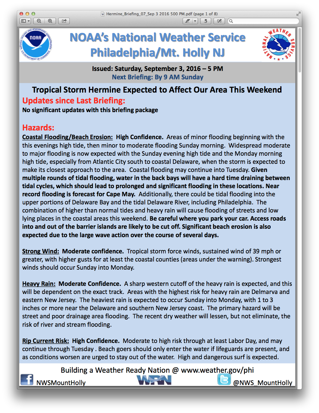
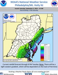
A persistent low pressure system continued to bring strong winds and periods of rain to our community during the overnight hours. Some occasional rain is expected to continue through the morning and possibly into the afternoon hours. Windy conditions will persist. There is the potential for periods of heavy rain over the next several hours. There is also the possibility for minor coastal flooding at time of high tide this morning. High tide will occur at the Townsend’s Inlet Bridge Friday morning at 8:53am and again this evening at 9:06pm.

Never attempt to drive on any flooded street as this puts you and your vehicle at risk. It is likely the road leading to the Townsend’s Inlet Bridge will be closed this morning due to waves coming onto the roadway.

Here is the text of this morning’s weather alert from the National Weather Service:

Flash Flood Watch, Coastal Flood Advisory, Coastal Hazard Statement
Issued: 3:49 AM EDT Sep. 30, 2016 – National Weather Service

… Flash Flood Watch remains in effect through this afternoon…

The Flash Flood Watch continues for

* portions of Delaware… northeast Maryland… southern New
Jersey and southeast Pennsylvania… including the following
areas… in Delaware… Delaware beaches… inland Sussex… Kent
and New Castle. In northeast Maryland… Caroline… Cecil…
Kent MD… Queen Annes and Talbot. In southern New Jersey…
Atlantic… Atlantic coastal Cape May… Camden… Cape May…
coastal Atlantic… coastal ocean… Cumberland… Gloucester…
northwestern Burlington… ocean… Salem and southeastern
Burlington. In southeast Pennsylvania… Delaware and
Philadelphia.

* Through this afternoon

* heavy rainfall will continue to affect the area through today.
Widespread 3 to 6 inches inches has fallen across portions of
the Delmarva and southern New Jersey over the last two days,
with higher amounts of 10-12 inches across far southern
Delaware. Additional periods of moderate to heavy rainfall today
will lead to more flooding and exacerbate existing flooding.

Precautionary/preparedness actions…

A Flash Flood Watch means that conditions may develop that lead
to flash flooding. Flash flooding is a very dangerous situation.

You should monitor later forecasts and be prepared to take action
should flash flood warnings be issued.

A coastal Flood Advisory means that minor tidal flooding is
expected. Minor tidal flooding often results in some Road
closures. Usually… the most vulnerable roadways will flood.

Do not leave your vehicle at a location that is prone to tidal
flooding. Do not drive your vehicle through flood waters. The
water may be deeper than you think it is. You will be putting
yourself in danger and your vehicle may be damaged… leading to
costly repairs.

For a list of the impact of different tide heights in your
County please go to www.Weather.Gov/phi/tides

There is a high risk of rip currents. A high risk of rip currents
implies that wind and/or wave conditions will support the
development of very strong rip currents. These rip currents will
be life threatening to anyone who enters the surf.

Rip currents are powerful channels of water flowing quickly away
from shore… which occur most often at low spots or breaks in The
Sandbar and in the vicinity of structures such as groins…
jetties and piers. Heed the advice of lifeguards… beach patrol
flags and signs.

If you become caught in a rip current… Yell for help. Remain
calm… do not exhaust yourself and stay afloat while waiting for
help. If you have to swim out of a rip current… swim parallel to
shore and back toward the beach when possible. Do not attempt to
swim directly against a rip current as you will tire quickly.

For a list of the impact of different tide heights in your County
please visit www.Weather.Gov/phi/tides

Fri, Sept. 30th, 7:09am: Flash Flood Watch, Coastal Flood Advisory for Stone Harbor2016-09-30T07:08:51-04:00

Thurs, Sept. 29th, 11:33am: Coastal Flood Warning Posted by National Weather Service

Flooding

The National Weather Service has posted a Coastal Flood Warning for the Borough of Stone Harbor for Thursday, September 29th at 6:00pm until Friday, September 30th at 1:00am.  Moderate coastal flooding is expected at time of high tide which will occur in Townsend’s Inlet at 8:28pm.  A persistent northeasterly flow has kept water from the Thursday morning high tide in the back bays.  This evening’s high tide is expected to produce an additional half foot to foot of tidal inundation flooding.  Please be advised that some local streets that typically receive water during coastal flooding events may have water this evening.  Do not attempt to drive on any flooded street or through any flooded intersection as this puts you and your vehicle at risk while also creating an unnecessary wake that can damage property and other vehicles.

The low pressure system that is causing the northeasterly winds and rain, heavy at times, is expected to linger near the East Coast for at least 24 hours.  There may be strong gusty winds, periods of heavy rainfall, or a thunderstorm at any time.  It is possible additional flood advisories may come from the National Weather Service.  High tide at the Townsend’s Inlet Bridge will occur on Friday at 8:53am and 9:06pm, and on Saturday at 9:29am and 9:42pm.

Here is the text of the Coastal Flood Warning provided by the National Weather Service:

Coastal Flood Warning, Coastal Flood Advisory, Coastal Hazard Statement
Issued: 10:27 AM EDT Sep. 29, 2016 – National Weather Service
  ... Coastal Flood Advisory now in effect until 3 PM EDT this  afternoon...   ... High rip current risk now in effect through late tonight...   ... Coastal Flood Warning in effect from 6 PM this evening to 1 am  EDT Friday...     The National Weather Service in Mount Holly has issued a coastal  Flood Warning... which is in effect from 6 PM this evening to 1 am  EDT Friday.    * Location... the central and southern New Jersey shore and    Delaware beaches.    * Coastal flooding... minor coastal flooding was occuring this    morning along the central and southern New Jersey coasts and the    Delaware coast. Tidal inundation flooding will occur again    tonight and probably be half a foot to a foot deeper than what    occurred this morning. This has prompted the upgrade of this    evenings advisory to a warning for moderate coastal flooding    with this evenings high tide cycle. Easterly winds will whip    waves of 5 to 9 feet onto the shore as well.    * Risk of rip currents... there is a high risk of dangerous rip    currents through tonight.    * Timing... the oceanfront coastal flooding is expected with the     high tides which between 7 and 9 am and 7 and 9 PM. High tide     on the Bay Side may occur up to 3 hours later. The high risk     of rip currents will continue through this evening.    * Impacts... roadway flooding is expected near both high tides.    * Surge... tides will be around 2 to 2.5 feet above astronomical    tides. Heavy rain at the time of high tides could exacerbate    coastal flooding... leading to total water levels even higher.    * Waves... 5 to 9 feet.    * Outlook... at least minor tidal inundation flooding is    anticipated with the Friday morning high tide cycle... and    possibly again Friday evening.    Precautionary/preparedness actions...     There is a high risk of rip currents. A high risk of rip currents  implies that wind and/or wave conditions will support the  development of very strong rip currents. These rip currents will  be life threatening to anyone who enters the surf.    Rip currents are powerful channels of water flowing quickly away  from shore... which occur most often at low spots or breaks in The  Sandbar and in the vicinity of structures such as groins...   jetties and piers. Heed the advice of lifeguards... beach patrol  flags and signs.    If you become caught in a rip current... Yell for help. Remain  calm... do not exhaust yourself and stay afloat while waiting for  help. If you have to swim out of a rip current... swim parallel to  shore and back toward the beach when possible. Do not attempt to  swim directly against a rip current as you will tire quickly.    A coastal Flood Advisory means that minor tidal flooding is  expected. Minor tidal flooding often results in some Road  closures. Usually... the most vulnerable roadways will flood.    Do not leave your vehicle at a location that is prone to tidal  flooding. Do not drive your vehicle through flood waters. The  water may be deeper than you think it is. You will be putting  yourself in danger and your vehicle may be damaged... leading to  costly repairs.
Thurs, Sept. 29th, 11:33am: Coastal Flood Warning Posted by National Weather Service2016-09-29T11:32:31-04:00

Mon, Sept. 5th: Tropical Storm Warning Cancelled, Flood Advisory in Effect

The National Weather Service has discontinued the Tropical Storm Warning for the entire coastline of New Jersey, including the Borough of Stone Harbor; a Coastal Flood Advisory is now in effect. The effects of the storm continue to be beach erosion, rough surf, strong rip currents, and minor coastal flooding at times of high tide.

Continue to observe all instructions provided by the Stone Harbor Beach Patrol as rip currents remain present along our beachfront.

The briefing provided by the National Weather Service on Monday, September 5th, at 6:42am provides for the potential of minor coastal flooding at time of high tide Monday morning and Monday evening. High tide at the Townsend’s Inlet Bridge on Monday will occur at 11:19am and again at 11:29pm.

Visitors to the Borough should be aware that driving on some main streets may become difficult during time of high tide Monday morning and Monday evening. At times, the Avalon Police Department may close the road leading to the Townsend’s Inlet Bridge for safety due to wave overwash on the roadway; this typically occurs near high tide.

Here is the text of the Coastal Flood Advisory posted by the National Weather Service:

… Coastal Flood Advisory in effect until 5 am EDT Tuesday…

… Coastal Flood Warning is cancelled…


The National Weather Service in Mount Holly has issued a coastal

Flood Advisory… which is in effect until 5 am EDT Tuesday. The

coastal Flood Warning has been cancelled.


* Location… coastal areas of New Jersey and Delaware.


* Coastal flooding… minor flooding is anticipated around the

times of high tide on this afternoon and again tonight.


* Timing… high tide on the New Jersey and Delaware oceanfront is

between 10:30 am and 11:30 am this morning… and between 10:30

PM and 11:30 PM this evening. High tide in the back bays occurs

later than the high tide on the oceanfront.


* Surge… 1 to 2 ft above the astronomical tide.


* Waves… 9 to 13 ft breaking waves in the surf zone.


* Rip currents… large swells and gusty northerly winds will

produce a high risk of dangerous rip currents.


* Impacts… localized roadway flooding is expected. Some roads may

be closed due to high water. Large and breaking waves will be

dangerous to anyone who enters the surf. There will also be

dangerous rip currents and beach erosion.


* Outlook… minor coastal flooding could occur again at times of

high tide on Tuesday if Post-Tropical Storm Hermine drifts back

westward toward the coast. Heavy surf and a high risk for rip

currents will likely persist into Tuesday or possibly Wednesday.


Precautionary/preparedness actions…


A coastal Flood Advisory means that minor tidal flooding is

expected. Minor tidal flooding often results in some Road

closures. Usually… the most vulnerable roadways will flood.


Do not leave your vehicle at a location that is prone to tidal

flooding. Do not drive your vehicle through flood waters. The

water may be deeper than you think it is. You will be putting

yourself in danger and your vehicle may be damaged… leading to

costly repairs.


A high rip current risk at the beaches will pose a serious threat

to life for any swimmers that decide to venture out into the

ocean.

Mon, Sept. 5th: Tropical Storm Warning Cancelled, Flood Advisory in Effect2016-09-05T07:06:17-04:00

Sun, Sept. 4, 5:34pm: Tropical Storm Warning Continues, Flooding a Threat on Monday

Hermine Sunday 5pm

The National Weather Service has continued the Tropical Storm Warning for the entire coastline of New Jersey, including the Borough of Stone Harbor. The Tropical Storm Warning remains in effect as Hermine continues to meander in the North Atlantic away from the New Jersey coastline. The effects of the storm continue to be gusty winds, beach erosion, rough surf, strong rip currents, and coastal flooding at times of high tide.

Throughout the day on Sunday, strong rip currents were present on the beachfront. Continue to observe all instructions provided by the Stone Harbor Beach Patrol

Winds Sunday night and Monday are expected to be out of the north at 25mph, with gusts to 35mph

The briefing provided by the National Weather Service on Sunday, September 4th, at 5:00pm provides for the potential of minor coastal flooding at time of high tide Sunday evening, and moderate coastal flooding at time of high tide Monday morning and Monday evening. High tide at the Townsend’s Inlet Bridge will occur Sunday at 11:25pm. High tide on Monday will occur at 11:19am and again at 11:29pm. High tide on Tuesday will occur at 11:59am. Minor to moderate coastal flooding is possible during Tuesday’s high tide.

Monday night tide

Visitors to the Borough should be aware that driving on some main streets may become difficult during times of high tide Monday morning and Monday evening. It is wise to plan your commute home a few hours before or after these high tide events. If you live in an area of Stone Harbor that typically floods during coastal storm events, consider moving your vehicle off the street. Never park your vehicle on any bridge in our community as larger emergency vehicles, including fire trucks, are blocked by vehicles parked on bridges. Never attempt to drive on any flooded street as this puts you at risk, and salt water will damage your vehicle. Driving on a flooded street also creates an unnecessary wake that can damage vehicles/property owned by others. At times, the Avalon Police Department may close the road leading to the Townsend’s Inlet Bridge for safety due to wave overwash on the roadway; this typically occurs near high tide.

If you have any emergency, dial 911. If you are home and see flooding in your street, it is best to shelter in your home until flood waters recede.

The Borough continues to be in contact with our partners at the Cape May County Office of Emergency Management and the New Jersey State Police. Continue to follow advisories regarding this storm on www.stoneharboremergency.com.

The Stone Harbor Office of Emergency Management wants to thank all of our residents, property owners, and visitors for paying close attention to the forecast and the advisories throughout this storm event.

Sun, Sept. 4, 5:34pm: Tropical Storm Warning Continues, Flooding a Threat on Monday2016-09-04T17:34:12-04:00

Sun, Sept. 4th, 9:43am: Tropical Storm Warning Continues, Coastal Flooding Remains Likely

Hermine Sunday 8am

The National Weather Service has continued the Tropical Storm Warning for the entire coastline of New Jersey, including the Borough of Stone Harbor. The Tropical Storm Warning remains in effect as Hermine continues to meander in the North Atlantic away from the New Jersey coastline. The storm is expected to increase in strength and become a Category One hurricane. The effects of the storm will still be felt in Stone Harbor as gusty winds, beach erosion, rough surf, strong rip currents, and coastal flooding at times of high tide remains present.

Observe all warnings provided by the Stone Harbor Beach Patrol.

Winds Sunday afternoon and Sunday evening will be out of the northeast at 25-35mph with gusts to 40mph. Rain showers are possible later in the day.

Hermine Sunday 9am NWS

The briefing provided by the National Weather Service on Sunday, September 4th, at 9:00am shows generally minor coastal flooding during time of high tide Sunday morning. Widespread moderate coastal flooding is forecast during time of high tide on Sunday evening. Moderate to potentially major tidal flooding is forecast for the Monday morning high tide. The storm may jog slightly closer to the coastline later today which could aggravate any flooding situation.

High tide at the Townsend’s Inlet Bridge will occur Sunday at 11:14am, and again at 11:25pm. High tide on Monday will occur at 11:53am. Visitors to the Borough should be aware that driving on some main streets may become difficult or impossible during times of high tide Sunday evening and Monday morning. It is wise to plan your commute home a few hours before or after these high tide events. If you live in an area of Stone Harbor that typically floods during coastal storm events, consider moving your vehicle off the street. Never park your vehicle on any bridge in our community as larger emergency vehicles, including fire trucks, are blocked by vehicles parked on bridges. Never attempt to drive on any flooded street as this puts you at risk, and salt water will damage your vehicle. Driving on a flooded street also creates an unnecessary wake that can damage vehicles/property owned by others.Continue to secure any objects that are prone to strong winds including trash cans and patio umbrellas. If you have any emergency, dial 911. If you are home and see flooding in your street, it is best to shelter in your home until flood waters recede.

Hermine Monday Tide

The Borough continues to be in contact with our partners at the Cape May County Office of Emergency Management and the New Jersey State Police. The Borough will participate in a meeting with Cape May County OEM at 11:00am today. Continue to follow advisories regarding this storm event on www.stoneharboremergency.com.

Sun, Sept. 4th, 9:43am: Tropical Storm Warning Continues, Coastal Flooding Remains Likely2016-09-04T09:42:50-04:00

Sat, Sept. 3rd, 5:50pm: Tropical Storm Warning Continues, Flooding Still Major Concern

Hermine Saturday 5pm NWS

The National Weather Service has continued the Tropical Storm Warning for the Borough of Stone Harbor during its latest briefing on Saturday, September 3rd, at 5:00pm. The Service has continued to forecast the potential for strong gusty winds, occasional rain, beach erosion, rough surf, strong rip currents, and moderate/potential major coastal flooding.   This Tropical Storm Warning continues for the Labor Day weekend holiday.

The latest computer models put the storm just offshore of the State of New Jersey with heavy rains and strong winds in the Atlantic Ocean. The forecast continues to show the storm moving away from the East Coast of the United States before taking a slight turn west towards the coastline Sunday night through Tuesday. The current forecast then calls for the storm to continue moving along the coastline to New England by Wednesday into Thursday. Tropical Storm Warnings remain for the entire coast of New Jersey. The weather risks to the Borough include wind gusts Saturday night into Sunday morning approaching 55mph, with additional rainfall expected Sunday through Labor Day Monday.

Hermine Saturday 5pm

There remains a significant threat of coastal flooding to the Borough during times of high tide. The tides of greatest concern remain the high tide events on Sunday evening and again on Monday morning. Visitors to Stone Harbor who plan to relocate to the mainland should consider doing so in between any high tide event when the flood risk is less.

High tide in Stone Harbor occurs at 10:48pm on Saturday; high tide on Sunday occurs at 11:14am and again at 11:25pm, and high tide on Monday will be at 11;53am.   Moderate to possibly major coastal flooding is expected at times of high tide on Sunday evening and Monday morning.

Hermine Saturday Monday Tides 5pm

In advance of any flood advisory, watch, or warning, consider moving your vehicle to higher ground. Never park your vehicle on a bridge or traffic island as these are needed for emergency vehicles, including fire trucks. Never attempt to drive your vehicle on any flooded street or through a flooded intersection as this puts you in danger and also creates an unnecessary wake that can damage private property and other vehicles.  It is best that you shelter at your property during times of high tide; rising tidal flooding typically subsides within a couple of hours of a high tide along the back bay.  If you have an emergency during the storm, please dial 911.

Bathers are not permitted to enter the ocean in Stone Harbor until further notice.  Boaters are asked to check on their boats, secure them, and if possible, remove them from slips. Secure all property prone to wind including trash cans, umbrellas, patio furniture, and the like.  You can expect intermittent closures of the Townsend’s Inlet Bridge between Avalon and Sea Isle City near times of high tide due to wave over wash on the road leading to the bridge.

Never attempt to move any downed utility wire. If you have a power outage, please report the outage to Atlantic City Electric at 1-800-833-7476. Be sure to have your street address available to report the outage.

Secure any loose outdoor objects including trash cans/lids, umbrellas, patio furniture, and flags.

Residents, property owners, and visitors are encouraged to constantly check www.stoneharboremergency.com for the latest updates, advisories, directions, and information regarding this storm.  Updates are also available on Avalon’s AM radio station, 1630AM.

Sat, Sept. 3rd, 5:50pm: Tropical Storm Warning Continues, Flooding Still Major Concern2016-09-03T17:48:32-04:00

Sat, Sept. 3rd, 10:51am: Latest National Weather Service Briefing Package on “Hermine”

Sat, Sept. 3rd, 10:51am: Latest National Weather Service Briefing Package on “Hermine”2016-09-03T14:52:58-04:00

Sat, Sept. 3rd, 2:14pm: Latest Forecast Map Released by National Weather Service

Hermine Saturday 200pm

Hurricane Local Statement

POST-TROPICAL CYCLONE HERMINE LOCAL STATEMENT ADVISORY NUMBER 25  DEZ001>004-MDZ008-012-015-019-020-NJZ001-007>010-012>027-PAZ054-055-060>062-070-071-101>106-040015-    THIS PRODUCT COVERS NEW JERSEY...DELAWARE...SOUTHEASTERN PENNSYLVANIA AND NORTHEAST MARYLAND.    **HERMINE EXPECTED TO PRODUCE SIGNIFICANT COASTAL FLOODING AND   STRONG WINDS NEAR THE DELAWARE AND NEW JERSEY COASTS THIS LABOR   DAY WEEKEND**    NEW INFORMATION  ---------------    * CHANGES TO WATCHES AND WARNINGS:      - A TROPICAL STORM WARNING HAS BEEN ISSUED FOR MIDDLESEX    * CURRENT WATCHES AND WARNINGS:      - A TROPICAL STORM WARNING IS IN EFFECT FOR MIDDLESEX      - A TROPICAL STORM WARNING REMAINS IN EFFECT FOR NEW        CASTLE...KENT...INLAND SUSSEX...DELAWARE BEACHES...WESTERN        MONMOUTH...EASTERN        MONMOUTH...SALEM...OCEAN...CUMBERLAND...ATLANTIC...CAPE        MAY...ATLANTIC COASTAL CAPE MAY...COASTAL ATLANTIC...COASTAL        OCEAN AND SOUTHEASTERN BURLINGTON    * STORM INFORMATION:      - ABOUT 230 MILES SOUTH OF ATLANTIC CITY NJ OR ABOUT 210 MILES        SOUTH OF DOVER DE      - 36.1N 75.2W      - STORM INTENSITY 65 MPH      - MOVEMENT EAST-NORTHEAST OR 60 DEGREES AT 15 MPH    SITUATION OVERVIEW  ------------------    TROPICAL STORM HERMINE IS CURRENTLY JUST EAST OF THE OUTER BANKS OF  NORTH CAROLINA. HERMINE WILL MOVE NORTHEASTWARD AND OFF THE MID-  ATLANTIC COAST THROUGH TONIGHT. THE STORM IS THEN EXPECTED TO MEANDER  OFF THE DELMARVA AND NEW JERSEY COASTS SUNDAY AND MONDAY BEFORE  GRADUALLY MOVE NORTHEASTWARD AND AWAY FROM THE AREA DURING THE MIDDLE  OF NEXT WEEK.    A TROPICAL STORM WARNING IS NOW IN EFFECT FOR MIDDLESEX COUNTY IN NEW  JERSEY. OTHERWISE, A TROPICAL STORM WARNING REMAINS IN EFFECT FOR ALL  OF DELAWARE AND COASTAL NEW JERSEY FROM CAPE MAY TO SANDY HOOK AND  ALONG DELAWARE BAY. THIS WARNING ALSO INCLUDES THE COASTAL WATERS AND  ALL OF DELAWARE BAY. SUSTAINED TROPICAL STORM FORCE WINDS ARE EXPECTED  OVER LAND AREAS NEAR THE ATLANTIC COAST AND THE SHORE OF DELAWARE BAY.  THERE IS A POTENTIAL FOR TROPICAL STORM FORCE WIND GUSTS FARTHER  INLAND ACROSS SOUTHERN AND CENTRAL NEW JERSEY AND POSSIBLY EXTENDING  BACK WEST INTO THE I-95 CORRIDOR.    MINOR TO MODERATE COASTAL FLOODING IS LIKELY AROUND THE TIMES OF HIGH  TIDE STARTING THIS EVENING. MODERATE COASTAL FLOODING IS LIKELY LATE  SUNDAY THROUGH MONDAY. POCKETS OF MAJOR COASTAL FLOODING ARE POSSIBLE  WITH THE HIGH TIDE CYCLE ON SUNDAY NIGHT AND MONDAY LATE MORNING,  PARTICULARLY ALONG THE DELAWARE AND SOUTHERN NEW JERSEY COAST  INCLUDING BACK BAYS, AS WELL AS THE SOUTHERN SHORE OF THE DELAWARE  BAY.    THERE IS A POTENTIAL FOR MORE THAN 2 INCHES OF RAINFALL, MAINLY EAST  OF THE THE I-95 CORRIDOR. SOME AREAS NEAR THE COAST IN DELAWARE AND  SOUTHERN NEW JERSEY MAY RECEIVE 3 TO 4 INCHES WITH LOCALLY HIGHER  AMOUNTS, WHICH COULD LEAD TO FLOODING. THE HEAVIEST RAIN IS  EXPECTED THIS AFTERNOON IN SOUTHERN DELAWARE AND LATE SUNDAY  THROUGH EARLY MONDAY ELSEWHERE ALONG THE COAST.    HAZARDOUS SEAS AND DANGEROUSLY ROUGH SURF CAN BE EXPECTED THIS HOLIDAY  WEEKEND AND POSSIBLY INTO THE MIDDLE OF NEXT WEEK. A HIGH RIP CURRENT  RISK CAN BE EXPECTED AT THE BEACHES DURING THIS TIME. SIGNIFICANT  BEACH EROSION IS EXPECTED WITH HEAVY SURF BREACHING DUNES.    POTENTIAL IMPACTS  -----------------    * SURGE:  PROTECT AGAINST LIFE-THREATENING SURGE HAVING POSSIBLE SIGNIFICANT  IMPACTS ACROSS COASTAL AREAS OF NEW JERSEY AND DELAWARE AND ALONG  THE SHORE OF DELAWARE BAY. POTENTIAL IMPACTS IN THIS AREA INCLUDE:      - AREAS OF INUNDATION ARE POSSIBLE WITH STORM SURGE FLOODING        ENHANCED BY WAVES. DAMAGE IS LIKELY TO SEVERAL BUILDINGS,        MAINLY NEAR THE COAST.      - SECTIONS OF NEAR-SHORE ESCAPE ROUTES AND SECONDARY ROADS COULD        BECOME WEAKENED OR WASHED OUT, ESPECIALLY IN USUALLY VULNERABLE        LOW SPOTS.      - MAJOR BEACH EROSION IS EXPECTED WITH HEAVY SURF BREACHING        DUNES. STRONG AND NUMEROUS RIP CURRENTS ARE EXPECTED.      - MODERATE DAMAGE TO MARINAS, DOCKS, BOARDWALKS, AND PIERS IS        ANTICIPATED. SEVERAL SMALL CRAFT MAY BE BROKEN AWAY FROM        MOORINGS, ESPECIALLY IN UNPROTECTED AREAS.    ALSO, PROTECT AGAINST LOCALLY HAZARDOUS SURGE HAVING POSSIBLE LIMITED  IMPACTS ALONG THE DELAWARE RIVER.    ELSEWHERE ACROSS NEW JERSEY...DELAWARE...SOUTHEASTERN PENNSYLVANIA  AND NORTHEAST MARYLAND., LITTLE TO NO IMPACT IS ANTICIPATED.    * WIND:  PROTECT AGAINST DANGEROUS WIND HAVING POSSIBLE SIGNIFICANT IMPACTS  ACROSS COASTAL AREAS OF NEW JERSEY AND DELWARE. POTENTIAL IMPACTS IN  THIS AREA INCLUDE:      - SOME DAMAGE TO ROOFING AND SIDING IS LIKELY, ALONG WITH DAMAGE        TO PORCHES, AWNINGS, CARPORTS, AND SHEDS. A FEW BUILDINGS WILL        EXPERIENCE WINDOW, DOOR, AND GARAGE DOOR FAILURES. MOBILE HOMES        MAY BE DAMAGED, ESPECIALLY IF UNANCHORED. UNSECURED LIGHTWEIGHT        OBJECTS COULD BECOME AIRBORNE.      - SEVERAL LARGE TREES MAY BE SNAPPED OR UPROOTED. SEVERAL FENCES        AND ROADWAY SIGNS COULD BE BLOWN OVER.      - SOME ROADS MAY BE IMPASSABLE FROM LARGE DEBRIS. A FEW BRIDGES,        CAUSEWAYS, AND ACCESS ROUTES MAY BE IMPASSABLE.      - THERE COULD BE SCATTERED POWER AND COMMUNICATIONS OUTAGES, BUT        MORE PREVALENT IN AREAS WITH ABOVE GROUND LINES.    ALSO, PROTECT AGAINST HAZARDOUS WIND HAVING POSSIBLE LIMITED IMPACTS  ACROSS INLAND PARTS OF NEW JERSEY, DELAWARE AND POSSIBLY AS FAR WEST AS  EASTERN MARYLAND AND SOUTHEAST PENNSYLVANIA.    * FLOODING RAIN:  PROTECT AGAINST LOCALLY HAZARDOUS RAINFALL FLOODING HAVING POSSIBLE  LIMITED IMPACTS ACROSS SOUTHERN DELAWARE AND SOUTHEASTERN NEW JERSEY.  POTENTIAL IMPACTS INCLUDE:      - LOCALIZED RAINFALL FLOODING MAY PROMPT A FEW EVACUATIONS.      - RIVERS AND TRIBUTARIES MAY QUICKLY RISE WITH SWIFTER CURRENTS.        SMALL STREAMS, CREEKS, CANALS, AND DITCHES MAY BECOME SWOLLEN        AND OVERFLOW IN SPOTS.      - FLOOD WATERS CAN ENTER A FEW STRUCTURES, ESPECIALLY IN        VULNERABLE SPOTS. RAPID PONDING OF WATER MAY OCCUR AT        UNDERPASSES, LOW-LYING SPOTS, AND POOR DRAINAGE AREAS. SEVERAL        STORM DRAINS AND RETENTION PONDS BECOME NEAR-FULL AND BEGIN TO        OVERFLOW. SOME BRIEF ROAD AND BRIDGE CLOSURES ARE POSSIBLE.    ELSEWHERE ACROSS NEW JERSEY...DELAWARE...SOUTHEASTERN PENNSYLVANIA  AND NORTHEAST MARYLAND LITTLE TO NO IMPACT IS ANTICIPATED.    PRECAUTIONARY/PREPAREDNESS ACTIONS  ----------------------------------    * OTHER PREPAREDNESS INFORMATION:  NOW IS THE TIME TO BRING TO COMPLETION ALL PREPARATIONS TO PROTECT  LIFE AND PROPERTY IN ACCORDANCE WITH YOUR EMERGENCY PLAN.    OUTSIDE PREPARATIONS SHOULD BE WRAPPED UP AS SOON AS POSSIBLE BEFORE  WEATHER CONDITIONS COMPLETELY DETERIORATE. ANY REMAINING EVACUATIONS  AND RELOCATIONS SHOULD BE EXPEDITED BEFORE THE ONSET OF TROPICAL  STORM FORCE WIND.    IF YOU ARE RELOCATING TO SAFE SHELTER, LEAVE AS EARLY AS POSSIBLE. IF  HEADING TO A COMMUNITY SHELTER, BECOME FAMILIAR WITH THE SHELTER  RULES BEFORE ARRIVAL, ESPECIALLY IF YOU HAVE SPECIAL NEEDS OR OWN A  PET. TAKE ESSENTIAL ITEMS WITH YOU FROM YOUR EMERGENCY SUPPLIES KIT.  CHECK THE LATEST WEATHER FORECAST BEFORE DEPARTING.    FAILURE TO ADEQUATELY SHELTER MAY RESULT IN SERIOUS INJURY OR LOSS OF  LIFE. ALWAYS HEED THE ADVICE OF LOCAL OFFICIALS AND COMPLY WITH ANY  ORDERS THAT ARE ISSUED. REMEMBER, DURING THE STORM 9 1 1 EMERGENCY  SERVICES MAY NOT BE ABLE TO IMMEDIATELY RESPOND IF CONDITIONS ARE  UNSAFE. THIS SHOULD BE A BIG FACTOR IN YOUR DECISION MAKING.    CHECK-IN WITH YOUR EMERGENCY POINTS OF CONTACT AMONG FAMILY, FRIENDS,  AND WORKMATES. INFORM THEM OF YOUR STATUS AND WELL-BEING. LET THEM  KNOW HOW YOU INTEND TO RIDE OUT THE STORM AND WHEN YOU PLAN TO  CHECK-IN AGAIN.    IF YOU ARE A VISITOR AND STILL IN THE AREA, LISTEN FOR THE NAME OF  THE CITY OR TOWN IN WHICH YOU ARE STAYING WITHIN LOCAL NEWS UPDATES.  BE SURE YOU KNOW THE NAME OF THE COUNTY IN WHICH IT RESIDES. PAY  ATTENTION FOR INSTRUCTIONS FROM LOCAL AUTHORITIES.    CLOSELY MONITOR NOAA WEATHER RADIO OR OTHER LOCAL NEWS OUTLETS FOR  OFFICIAL STORM INFORMATION. BE READY TO ADAPT TO POSSIBLE CHANGES TO  THE FORECAST.  
Sat, Sept. 3rd, 2:14pm: Latest Forecast Map Released by National Weather Service2016-09-03T14:16:04-04:00

Sat, Sept. 3rd, 10:10am: Stone Harbor OEM Asks Visitors to Consider Leaving Between High Tides on Saturday

The Stone Harbor Office of Emergency Management is asking visitors to consider leaving the Borough of Stone Harbor during the afternoon and early evening hours on Saturday, September 3rd. The National Weather Service is calling for the possibility of a “life threatening storm surge” during this event, which is expected to linger off the coast for at least a few days. High tide in Stone Harbor occurs at 10:36am, and again at 10:48pm on Saturday; high tide on Sunday occurs at 11:14am and again at 11:25pm. Moderate to potentially major coastal flooding is expected at times of high tide on Sunday and again on Monday. Weather and flooding conditions may worsen on Sunday and Monday. If the storm remains off of our coast for an extended period of time, it may worsen subsequent high tide events over the next few days.

During significant tidal events in the Borough, driving on some portions of major roadways may be very difficult or impossible. Never attempt to drive on any flooded street for any reason at any time. You endanger yourself, compromise your vehicle with salt water, and create a wake that can damage others’ personal property when you drive through flood waters.

Bathers are not permitted to enter the ocean in Stone Harbor until further notice. Boaters are asked to check on their boats, secure them, and if possible, remove them from slips. Secure all property prone to wind including trash cans, umbrellas, patio furniture, and the like. The Townsend’s Inlet Bridge between Avalon and Sea Isle City was closed at 10:00am due to flooding.

The Stone Harbor Office of Emergency Management will be involved in a meeting with the Cape May County Office of Emergency Management later this morning to obtain further guidance, directions, and anticipated impact from this tropical storm system.

Residents, property owners, and visitors are encouraged to constantly visit www.stoneharboremergency.com for the latest updates, advisories, directions, and information regarding Tropical Storm Hermine.

Sat, Sept. 3rd, 10:10am: Stone Harbor OEM Asks Visitors to Consider Leaving Between High Tides on Saturday2016-09-03T14:10:59-04:00

Sat, Sept. 3, 8:24am: Tropical Storm Warning Remains for Stone Harbor

Hermine Saturday 8am

The National Weather Service has posted a Tropical Storm Warning for the Borough of Stone Harbor through Labor Day weekend. The Service provided its latest advisory to emergency management partners on Saturday, September 3rd, at 5:00am. As of 7:00am, rain was as close as Lewes, Delaware and winds are picking up on the 7 Mile Beach. The effects of Tropical Storm Hermine will be felt in our region starting on Saturday and lasting through Monday. The effects may include strong wind, rain, moderate coastal flooding, rough surf, beach erosion, and strong rip currents along the New Jersey coastline. Rain is expected to develop Saturday morning, and increase in intensity Saturday afternoon through Sunday. Stronger winds are possible Sunday into Sunday evening.

Computer models agree that the storm will move along the southeast coast and likely venture towards the east near the coastline of New Jersey. There is a potential for the storm to stall in the Atlantic Ocean and strengthen to a Category One hurricane which could prolong effects along our beaches, especially regarding rough surf and dangerous rip currents.

The Borough may experience minor to moderate coastal flooding at time of high tide especially Saturday evening and during the two high tide events on Sunday. High tide at the Townsend’s Inlet Bridge on Saturday, September 3rd will occur at 10:36am and again at 10:48pm; high tide will occur on Sunday, September 4th at 11:14am and again at 11:25pm. High tide will occur on Monday at 11:53am, and again Tuesday at 12:03am.

In advance of any flood advisory, watch, or warning, consider moving your vehicle to higher ground. Never park your vehicle on a bridge or traffic island. Street flooding may also occur during periods of heavy rainfall. Never attempt to drive your vehicle on any flooded street or through a flooded intersection as this puts you in danger and also creates an unnecessary wake that can damage private property and other vehicles. It is best that you shelter at your property during times of high tide; rising tidal flooding typically subsides within a couple of hours of a high tide along the back bay. If you have an emergency during the storm, please dial 911.

Please obey all instructions provided by the Stone Harbor Beach Patrol. Do not enter the ocean unless you are in the presence of an on-duty lifeguard. Do not enter the ocean before or after guards are on duty. Be aware that rip currents may take swimmers away from the water’s edge very quickly.
Never attempt to move any downed utility wire. If you have a power outage, please report the outage to Atlantic City Electric at 1-800-833-7476. Be sure to have your street address available to report the outage.

Secure any loose outdoor objects including trash cans/lids, umbrellas, patio furniture, and flags. Contractors have been told to secure their active job sites in advance of strong winds.

Stone Harbor will continue to provide alerts on our weather conditions at www.stoneharboremergency.com, Channel 97 for Comcast cable customers and when necessary, our Code Red emergency telephone call system.  The Stone Harbor Farmers Market for Sunday has been cancelled.

Here is the latest advisory from the National Weather Service regarding Tropical Storm Hermine:

… Tropical Storm Warning remains in effect…

* locations affected
– Cape May
– Wildwood

* wind
– latest local forecast: equivalent tropical storm force wind
– peak wind forecast: 35-45 mph with gusts to 60 mph
– window for tropical storm force winds: Sunday morning until
Tuesday afternoon

– current threat to life and property: moderate
– the wind threat has remained nearly steady from the
previous assessment.
– Emergency plans should include a reasonable threat for
strong tropical storm force wind of 58 to 73 mph.
– To be safe, earnestly prepare for the potential of
significant wind impacts. Remaining efforts to secure
properties should now be brought to completion.
– Dangerous wind is possible. Failure to adequately shelter
may result in serious injury, or in some cases loss of
life. Move to safe shelter before the wind becomes
hazardous.

– Potential impacts: significant
– some damage to roofing and siding is likely, along with
damage to porches, awnings, carports, and sheds. A few
buildings will experience window, door, and garage door
failures. Mobile homes may be damaged, especially if
unanchored. Unsecured lightweight objects could become
airborne.
– Several large trees may be snapped or uprooted. Several
fences and roadway signs could be blown over.
– Some roads may be impassable from large debris. A few
bridges, causeways, and access routes may be impassable.
– There could be scattered power and communications outages,
but more prevalent in areas with above ground lines.

* Storm surge
– latest local forecast: life-threatening storm surge possible
– peak storm surge inundation: the potential for 2-4 feet
above ground somewhere within surge prone areas
– window of concern: begins this evening

– current threat to life and property: moderate
– the storm surge threat has remained nearly steady from the
previous assessment.
– Emergency considerations should posture for a reasonable
threat for dangerous storm surge flooding of greater than 3
feet above ground.
– To be safe, evacuees should be located within prescribed
shelters and well away from storm surge flooding capable of
significant impacts.
– Life threatening inundation is possible. Those who failed
to heed evacuation orders risk serious injury or loss of
life.

– Potential impacts: significant
– areas of inundation are possible with storm surge flooding
enhanced by waves. Damage is likely to several buildings,
mainly near the coast.
– Sections of near-shore escape routes and secondary roads could
become weakened or washed out, especially in usually vulnerable
low spots.
– Major beach erosion is expected with heavy surf breaching
dunes. Strong and numerous rip currents are expected.
– Moderate damage to marinas, docks, boardwalks, and piers is
anticipated. Several small craft may be broken away from
moorings, especially in unprotected areas.

* Flooding rain
– latest local forecast:
– peak rainfall amounts: 2-4 inches, with locally
higher amounts

– current threat to life and property: elevated
– the flooding rain threat has remained nearly steady from
the previous assessment.
– Emergency plans should include a reasonable threat for
minor flooding where peak rainfall totals are near amounts
conducive for localized flash flooding and rapid inundation.
– To be safe, prepare for the potential of limited flooding
rain impacts.
– Localized flooding is possible. If flood related watches
and warnings are issued, heed recommended actions.

– Potential impacts: limited
– localized rainfall flooding may prompt a few evacuations.
– Rivers and tributaries may quickly rise with swifter
currents. Small streams, creeks, canals, and ditches may
become swollen and overflow in spots.
– Flood waters can enter a few structures, especially in
vulnerable spots. Rapid ponding of water may occur at
underpasses, low-lying spots, and poor drainage areas.
Several storm drains and retention ponds become near-full
and begin to overflow. Some brief Road and bridge closures
are possible.

Sat, Sept. 3, 8:24am: Tropical Storm Warning Remains for Stone Harbor2016-09-03T12:25:11-04:00
Go to Top