Wed, Sept. 30th, 7:08pm: Coastal Flood Watch, High Wind Watch Posted for Stone Harbor

The National Weather Service has issued the first weather watches associated with the low pressure system that will bring wind, rain, and the potential for coastal flooding in advance of the effects of Hurricane Joaquin. A Coastal Flood Watch is in effect from Thursday morning through Saturday afternoon, while a High Wind Watch is in effect from Friday morning through Saturday afternoon.Flooding

A low pressure system that is near the Jersey Shore is expected to bring occasional rain, gusty winds, and coastal flooding to our region through Saturday in advance of Hurricane Joaquin. The potential exists for moderate to major coastal flooding through Saturday. Coastal flooding typically occurs a few hours around the hours of high tide. During periods of high tide for the next three days, you are advised to be aware of the potential for street and road flooding. Never attempt to drive through any flooded intersection or any flooded street as it puts yourself and emergency responders in danger.

High tide at the Townsend’s Inlet Bridge between Avalon and Sea Isle City will occur on Thursday at 11:05am and again at 11:34pm; high tide on Friday at the bridge will occur at 12 Noon; high tide Saturday at the bridge will occur at 12:32am and again at 12:58pm. Please continue to monitor this website for updates for the potential of minor to moderate coastal flooding.

The High Wind Watch will result in northeasterly winds along our coastal communities at 25-35mph with gusts potentially as high as 60mph on Friday and Saturday. Please secure any outdoor objects that may be subject to high winds including lawn and patio furniture, trash cans, and the like. Contractors should make necessary arrangements to secure their active work sites that would be subject to high winds. The winds combined with high tides are expected to cause rough surf and beach erosion. Please exercise extreme caution on the beach for the next few to several days.

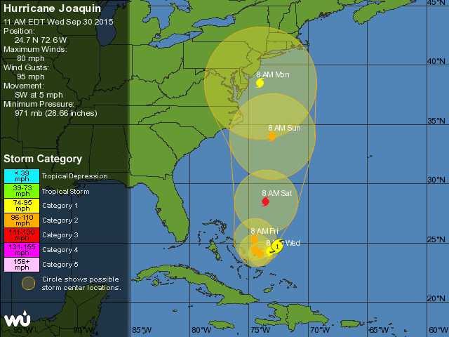
The projected path for Hurricane Joaquin continues to be adjusted by forecasters. The current forecast for the hurricane calls for a strengthening of the storm before it tracks northerly along the eastern seaboard. It is still unclear if the storm will make landfall, but many computer models predict a Category 1 hurricane or a strong tropical storm making landfall north of the Carolinas and south of northern New England. Regardless, the East Coast is projected to feel the impacts of this storm directly, or indirectly.

Please continue to monitor forecasts from area media outlets. Heed all advisories and warnings issued by your emergency management team, and by the National Weather Service. If you have any emergency, please dial 911. There is the potential for significant weather issues in our region over the next five days. We continue to monitor this storm, and continue to work with our local, county, and state emergency management partners and forecasters to provide you with the most accurate, timely information.

Here are the texts of the Coastal Flood Watch and the High Wind Watch as provided by the National Weather Service:

…COASTAL FLOOD WATCH IN EFFECT FROM THURSDAY MORNING THROUGH
SATURDAY AFTERNOON…
…HIGH RIP CURRENT RISK IS CANCELLED…

THE NATIONAL WEATHER SERVICE IN MOUNT HOLLY HAS ISSUED A COASTAL
FLOOD WATCH…WHICH IS IN EFFECT FROM THURSDAY MORNING THROUGH
SATURDAY AFTERNOON. THE HIGH RIP CURRENT RISK HAS BEEN CANCELLED.

* RIP CURRENTS…THE HIGH RISK FOR DANGEROUS RIP CURRENTS HAS BEEN
CANCELLED. HOWEVER, CONDITIONS ALONG THE COAST REMAIN DANGEROUS.
EXERCISE CAUTION IF IN OR NEAR THE OCEAN THROUGH THIS WEEKEND.

* COASTAL FLOODING…WIDESPREAD MODERATE TIDAL FLOODING IS
EXPECTED IN MULTIPLE SUCCESSIVE HIGH TIDE CYCLES BEGINNING
MIDDAY THURSDAY AND POSSIBLY LASTING INTO THE WEEKEND FOLLOWING
A RESUMPTION OF STRONG NORTHEAST WINDS, A BUILDING SURGE, AND 8
TO 12 FOOT BREAKING WAVES. MAJOR COASTAL FLOODING IS POSSIBLE
DURING THE HIGH TIDE CYCLES ON FRIDAY AND SATURDAY.

* TIMING…FLOODING MAY OCCUR FOR A FEW HOURS AROUND THE TIME OF
HIGH TIDE. HIGH TIDE OCCURS ALONG THE OCEANFRONT BETWEEN 1030 AM
AND 1200 PM THURSDAY. HIGH TIDE ON THE BACK BAYS OCCURS LATER
THAN THE HIGH TIDE ON THE OCEANFRONT.

* IMPACTS…NUMEROUS ROADWAYS MAY FLOOD AND MINOR TO MODERATE
PROPERTY DAMAGE IS POSSIBLE. THE TIDES AND WAVE ACTION COULD
RESULT IN MODERATE BEACH EROSION.

PRECAUTIONARY/PREPAREDNESS ACTIONS…

A COASTAL FLOOD WATCH MEANS THAT CONDITIONS FAVORABLE FOR THE
DEVELOPMENT OF MODERATE OR MAJOR TIDAL FLOODING.

BE PREPARED TO BEGIN TAKING APPROPRIATE ACTION TO PROTECT LIFE
AND PROPERTY. FOLLOW THE RECOMMENDATIONS OF LOCAL EMERGENCY
MANAGEMENT OFFICIALS. BE SURE TO CHECK THE LATEST FORECAST FROM
TIME TO TIME IN CASE A WARNING IS ISSUED OR ANY NEW INFORMATION
BECOMES AVAILABLE.

FOR A LIST OF THE IMPACT OF DIFFERENT TIDE HEIGHTS IN YOUR COUNTY
PLEASE VISIT WWW.ERH.NOAA.GOV/PHI/TIDES.HTM (ALL IN LOWER CASE)
LOCATION TIME OF PREDICTED WATER LEVEL
HIGH TIDE

ATLANTIC CITY, NJ 1031 AM THU 6.5 TO 7.0 FEET MLLW
(OCEANFRONT)

CAPE MAY, NJ 1105 AM THU 7.5 TO 8.0 FEET MLLW
(OCEANFRONT)

LEWES, DE 1146 AM THU 7.0 TO 7.5 FEET MLLW
(DELAWARE BAY)

REHOBOTH BEACH, DE 1051 AM THU 7.0 TO 7.5 FEET MLLW
(OCEANFRONT)

HIGH TIDE ON THE BACK BAYS…ALONG THE DELAWARE BAY…AND ALONG
THE RARITAN BAY OCCURS LATER THAN THE HIGH TIDE ON THE OCEANFRONT
High Wind Watch
URGENT – WEATHER MESSAGE
NATIONAL WEATHER SERVICE MOUNT HOLLY NJ
444 PM EDT WED SEP 30 2015
DEZ004-NJZ014-024>026-010900-
/O.NEW.KPHI.HW.A.0002.151002T1000Z-151003T2200Z/
DELAWARE BEACHES-EASTERN MONMOUTH-ATLANTIC COASTAL CAPE MAY-
COASTAL ATLANTIC-COASTAL OCEAN-
INCLUDING THE CITIES OF…REHOBOTH BEACH…SANDY HOOK…
OCEAN CITY…ATLANTIC CITY…LONG BEACH ISLAND
444 PM EDT WED SEP 30 2015

…HIGH WIND WATCH IN EFFECT FROM FRIDAY MORNING THROUGH SATURDAY
AFTERNOON…

THE NATIONAL WEATHER SERVICE IN MOUNT HOLLY HAS ISSUED A HIGH
WIND WATCH…WHICH IS IN EFFECT FROM FRIDAY MORNING THROUGH
SATURDAY AFTERNOON.

* WINDS…NORTHEAST 25 TO 35 MPH WITH SCATTERED GUSTS OF 55 TO 60
MPH POSSIBLE FRIDAY OR SATURDAY.

* TIMING…UNCERTAIN ON WHEN THE STRONGEST GUSTS OCCUR.

* IMPACTS…THIS WOULD GREATLY IMPACT HIGH PROFILE VEHICLE TRAVEL
ON BRIDGES AND OVERPASSES AND POSSIBLY FORCE CANCELLATION OF
SERVICES ALONG THE COASTS. TRAVEL IN PERIODS OF RAIN AND
DRIZZLE WOULD BE DIFFICULT.

PRECAUTIONARY/PREPAREDNESS ACTIONS…

A HIGH WIND WATCH MEANS THERE IS THE POTENTIAL FOR A HAZARDOUS
HIGH WIND EVENT. SUSTAINED WINDS OF AT LEAST 40 MPH…OR GUSTS OF
58 MPH OR STRONGER MAY OCCUR. CONTINUE TO MONITOR THE LATEST
FORECASTS.

Wed, Sept. 30th, 7:08pm: Coastal Flood Watch, High Wind Watch Posted for Stone Harbor2015-09-30T23:09:16-04:00

Wed, Sept. 30th, 5:25pm: Stormy Conditions Before Hurricane Joaquin

The National Weather Service continues to track a difficult forecast for Stone Harbor and the entire East Coast of the United States over the next several days. Hurricane Joaquin continues to gain strength and is a threat to the eastern seaboard; in advance of Joaquin, there is unsettled weather to contend with at the Jersey Shore.

Our short term forecast includes the threat of rain, gusty winds, and the potential for coastal flooding associated with a low pressure system. Rain is expected to move back into our forecast on Thursday with periods of rain, heavy at times, with north-northeasterly winds at 20-30mph. This rain is expected to continue through Friday night with potential for a few inches of rain and possibly minor to moderate coastal flooding at time of high tide.

High tide at the Townsend’s Inlet Bridge between Avalon and Sea Isle City will occur on Thursday at 11:05am and again at 11:34pm; high tide on Friday at the bridge will occur at 12 Noon; high tide Saturday at the bridge will occur at 12:32am and again at 12:58pm. Please continue to monitor this website for updates for the potential of minor to moderate coastal flooding. Never attempt to drive on a flooded street or through a flooded intersection. Contractors should be aware to secure active construction sites shall very windy conditions develop. If you have an emergency, please dial 911.

As of Wednesday at 5:00pm, no coastal flood advisories, watches, or warnings have been issued by the National Weather Service.

The forecast is complicated by the path of Hurricane Joaquin. As of Wednesday, September 30th, at 5:00pm the hurricane is forecast to increase in strength to a Category 3 storm off the coast of the United States, and then make a turn towards the shoreline. The storm is forecast to be downgraded to a Category 1 hurricane or even a tropical storm by the time it makes landfall. The projected path of the storm has changed several times over the past 24 hours and continued changes to the path of the storm are expected from forecasters. Many current models put this storm close to or over the outer banks of North Carolina Sunday afternoon

It is important for you to be aware of the short term forecast involving our rain/wind/potential for flooding through the early part of the weekend, and also to be aware of the path of this hurricane which poses a threat to the eastern seaboard. The Stone Harbor Office of Emergency Management continues to work with the Cape May County Office of Emergency Management and our emergency partners to prepare for the potential for bad weather over the next five days or so.

Continue to monitor traditional media outlets for the latest information, and www.avalonemergency.org. If you have any emergency, dial 911. Never attempt to drive on any flooded street or intersection. Please observe all instructions provided to you by emergency management officials.

Wed, Sept. 30th, 5:25pm: Stormy Conditions Before Hurricane Joaquin2015-09-30T21:25:51-04:00

Wed, September 30th, 11:20am: Stormy Conditions, Hurricane Forms in Atlantic

The Stone Harbor Office of Emergency Management is monitoring unsettled weather in our forecast over the next few days, including the formation of Hurricane Joaquin.  The National Weather Service has issued a discussion for rain and wind, and the potential for minor to moderate coastal flooding in Stone Harbor and other coastal communities over the next few days associated with a low pressure system.  The discussion and graphic provided by the National Weather Service is as follows:

National Weather Service Forecast Discussion September 30

Stone Harbor may expected to receive rain, heavy at times, along with northeasterly winds between 25-35mph with higher gusts during this coastal low.  Minor to moderate flooding is possible at time of high tide, especially on Friday.  High tide at the Townsend’s Inlet Bridge between Avalon and Sea Isle City will occur on Thursday at 11:05am and again at 11:34pm; high tide on Friday at the bridge will occur at 12 Noon; high tide Saturday at the bridge will occur at 12:32am and again at 12:58pm.  Please continue to monitor this website for updates for the potential of minor to moderate coastal flooding.  Never attempt to drive on a flooded street or through a flooded intersection.  Contractors should be aware to secure active construction sites shall very windy conditions develop.  If you have an emergency, please dial 911.

In addition, the National Weather Service is also keeping a close eye on the development of Hurricane Joaquin.  The Wednesday, 11:00am advisory puts the storm on a track that will bring it along the eastern seaboard, including New Jersey.  The storm is expected to intensify and then lose strength before it approaches New Jersey during the latter part of the weekend and on Monday.  The current path of the storm as predicted by the National Weather Service is shown below.  Please understand that computer models have different views of the path of the storm, and the path is certainly subject to change:

Hurricane Joaquin Wednesday September 30 11am

The Stone Harbor Office of Emergency Management is working with the Cape May County Office of Emergency Management and our other emergency partners to monitor the track of this storm and the potential impact on our region.  Please continue to follow traditional media outlets for information regarding this storm, and always reference www.stoneharboremergency.com for updates.

Wed, September 30th, 11:20am: Stormy Conditions, Hurricane Forms in Atlantic2015-09-30T15:23:48-04:00

Tues, Sept. 29th: Tropical Storm Forms, Rain/Wind Later This Week

The National Weather Service is alerting coastal communities, including Stone Harbor, about the upcoming storm event towards the end of this week. Tropical Storm Joaquin has formed in the Atlantic Ocean and will move up the eastern seaboard of the United States over the next several days. The storm is expected to bring rain and wind to our region towards the end of this week.

The Stone Harbor Office of Emergency Management continues to monitor this storm as it continues to develop and move in a northerly direction. Please continue to monitor traditional media outlets for updated information. We will provide updates on this website and on Channel 97 for Comcast television customers.

Currently, there are no advisories, watches, or warnings issued by the National Weather Service. Please click on the PDF link for a summary of the storm provided by the National Weather Service:

National Weather Service Briefing Tropical Storm Joaquin September 29 2015

Tues, Sept. 29th: Tropical Storm Forms, Rain/Wind Later This Week2015-09-29T17:38:02-04:00

Mon, September 28th: Heavy Rain, Winds Possible By Week’s End

The National Weather Service has issued an advisory to emergency management coordinators along the New Jersey coastline about the potential for a coastal storm during the latter part of this week.  A tropical system is expected to be off the coast of New Jersey by Friday morning, and the potential exists for rain, heavy at times, and gusty winds along the coastal region.  Please continue to monitor this storm via traditional media outlets during the week and check this website for additional information as it becomes available.

National Weather Service Weather Briefing Monday September 28 2015


Mon, September 28th: Heavy Rain, Winds Possible By Week’s End2015-09-28T19:58:17-04:00
Go to Top